
Frost Advisory For Some Tonight; Pleasant Tuesday In South Central Pennsylvania
Highs will stay in the 60s through Thursday, then temperatures will warm at the end of the week.
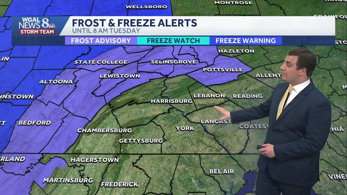
OUR WEBSITE WGAL.COM. AND THE WGAL NEWS EIGHT STORM TEAM FORECAST WITH METEOROLOGIST MIKE SUSKO. GOOD AFTERNOON EVERYONE. MIFFLIN COUNTY WILL BE UNDER A FROST ADVISORY TONIGHT HERE FROM THE NATIONAL WEATHER SERVICE. JUST CAME OUT ABOUT TEN MINUTES AGO HERE. EVERYONE ELSE THOUGH, DOES NOT HAVE TO WORRY ABOUT FROST. AND THE REASON WHY IS TEMPERATURES ARE JUST GOING TO BE TOO WARM. WILL BE IN THE LOW TO MID 40S FOR THE REST OF THE SUSQUEHANNA VALLEY IS JUST THE HIGHER ELEVATIONS THAT COULD GET A LITTLE BIT COOLER OVERNIGHT TONIGHT, IN PART BECAUSE WE’RE ALSO GOING TO SEE THE CLOUDS MOVING OUT FASTER FOR YOU. SO THE CLOUDS ALREADY STARTING TO THIN OUT ACROSS AREAS OF THE WEST SHORE THERE WEST OF THE SUSQUEHANNA RIVER AND ON THE EAST, WE’RE STILL GETTING SOME OF THOSE CLOUDS TO HANG AROUND. THAT’S ALL BECAUSE OF THIS RAIN THAT YOU SEE TO THE SOUTH AND EAST. IT IS PULLING AWAY, BUT IT’S GOING TO TAKE SOME TIME TO GET RID OF THE CLOUDS. THROUGHOUT THE DAY WE WILL SEE A HIGH AROUND 64 DEGREES FOR MOST OF THE AREA. EVEN THOUGH THE TEMPERATURES RIGHT NOW ARE IN THE 50S, WE DO EXPECT THEM TO WARM UP A LITTLE BIT AS WE GO INTO THE AFTERNOON TONIGHT, DROPPING BACK TO 42 TO 46 DEGREES FOR MOST OF THE AREA. AGAIN, UNLESS YOU’RE IN MIFFLIN COUNTY, YOU MAY DROP DOWN TO AS LOW AS 36 DEGREES, WHICH IS WHY YOU HAVE THE FROST ADVISORY TOMORROW. MOSTLY SUNNY. IT’S A PLEASANT DAY. WE’RE LOOKING AT TEMPERATURES IN THE UPPER 60S AND EVEN NEAR 70 DEGREES. WINDS WILL BE OUT OF THE NORTHWEST, BECOMING SOUTHEAST IN THE AFTERNOON LIGHT AROUND 5 TO 10MPH. YOUR TEN DAY FORECAST SHOWING OUR NEXT BEST CHANCE FOR RAIN IS ON WEDNESDAY. THAT’S WHY YOU SEE THE IMPACT DAY THERE. JUST WANT TO HIGHLIGHT THAT THE RAIN COULD BE ON WEDNESDAY IN THE AFTERNOON. IT’S NOT GOING TO BE A BIG RAIN EVENT THOUGH. WE’LL SHOW YOU THAT HERE IN A SECOND. BUT 62 DEGREES ON THURSDAY, 70 ON FRIDAY. AND THEN WE GET TO 76 BY SATURDAY, WITH LOW 80S RETURNING BY SUNDAY. SO WE WANT THAT SUMMERLIKE WARMTH. IT’S ALMOST ON THE WAY. BUT HARRISBURG RIGHT NOW, WE’VE GOT THE CLOUDS IN PLACE ACROSS THE AREA HERE AND TEMPERATURES ACROSS THE REGION ARE BELOW AVERAGE. KEEP IN MIND, WE SHOULD BE IN THE LOW 70S THIS TIME OF YEAR. WE’RE GOING TO BE IN THE 50S HERE FOR RIGHT NOW 54 IN HARRISBURG. SAME THING IN HERSHEY, 53 IN LANCASTER. IT’S 53 IN YORK AS WELL, 55 IN CASHTOWN THIS TIME. THIS ALL OUT FOR YOU. SO THOSE CLOUDS MOVE ON OUT. THAT’S WHEN THE SUN WILL COME BACK OUT. AND ALSO WARM THINGS UP IN THE AFTERNOON AND EVENING. TONIGHT WE CLEAR OUT WITH HIGH PRESSURE COMING INTO THE PICTURE THAT BIG BLUE H IS GOING TO BRING US LOTS OF SUNSHINE TOMORROW. ON YOUR WEDNESDAY WE SEE THE CLOUDS, ESPECIALLY IN THE MORNING HOURS HERE, BUT MOST OF THE RAIN WILL HOLD OFF UNTIL THE AFTERNOON. RIGHT AROUND THAT TWO, THREE, 4:00 HOUR BEFORE THE FRONT PUSHES THROUGH DURING THE EVENING AND COULD BRING US SOME SHOWERS AND THUNDERSTORMS AS WE GO THROUGH THE EVENING HOURS. BUT HOW MUCH RAIN ARE WE TALKING? GENERALLY AROUND A QUARTER TO A HALF AN INCH OF RAIN IS POSSIBLE IN SOME SPOTS HERE. IF YOU CAN GET UNDER SOME OF THOSE THUNDERSTORMS, YOU MAY GET A LITTLE BIT MORE THAN THAT, BUT IT’S NOT GOING TO BE A BIG RAIN MAKER FOR OUR AREA HERE AT ALL AS WE GO INTO WEDNESDAY. SO AGAIN, JUST KIND OF WANT TO HIGHLIGHT THAT WE WILL GET SOME RAIN WEDNESDAY, BUT IT’S NOT GOING TO BE A BIG DEAL AS WE GO INTO THE WEEK, TOWARDS THE WEEKEND, WE GO BACK UP TO NEAR 70 DEGREES BY FRIDAY AND THEN 76 ON YOUR SATURDAY, 80 DEGREES BY THE TIME WE G
Frost Advisory For Some Tonight; Pleasant Tuesday In South Central Pennsylvania
Highs will stay in the 60s through Thursday, then temperatures will warm at the end of the week.

Updated: 1:08 PM EDT May 11, 2026
Good afternoon, The clouds stick around throughout the afternoon, with some breaks in the clouds. Highs will reach the low to mid-60s, with light winds. As an upper-level disturbance passes this evening, a spotty shower is possible.Tonight, lows will fall to the low 40s under mostly clear skies.High pressure building in from the Midwest will provide plentiful sunshine and warmer temperatures on Tuesday. Look for highs in the upper 60s.A warm front will lift north on Wednesday morning, leading to a few showers. Ahead of a cold front, scattered showers are likely in the afternoon. The front will arrive on Wednesday evening, with a few rumbles of thunder. Highs will reach the mid-60s, and rain totals will be around a tenth of an inch.Thursday will be cooler, with a few leftover showers and highs in the low 60s.By the end of the workweek, temperatures will rebound to 70 degrees under partly sunny skies.Temperatures trend warmer this weekend. Expect mid-70s Saturday, and highs near 80 Sunday. Isolated showers are possible on Sunday.Next week, temperatures will remain above average in the low 80s through Tuesday. The highest chance of showers comes Tuesday into early Wednesday.Have a great day!
Good afternoon,
The clouds stick around throughout the afternoon, with some breaks in the clouds. Highs will reach the low to mid-60s, with light winds. As an upper-level disturbance passes this evening, a spotty shower is possible.
Tonight, lows will fall to the low 40s under mostly clear skies.
High pressure building in from the Midwest will provide plentiful sunshine and warmer temperatures on Tuesday. Look for highs in the upper 60s.
A warm front will lift north on Wednesday morning, leading to a few showers. Ahead of a cold front, scattered showers are likely in the afternoon. The front will arrive on Wednesday evening, with a few rumbles of thunder. Highs will reach the mid-60s, and rain totals will be around a tenth of an inch.
Thursday will be cooler, with a few leftover showers and highs in the low 60s.
By the end of the workweek, temperatures will rebound to 70 degrees under partly sunny skies.
Temperatures trend warmer this weekend. Expect mid-70s Saturday, and highs near 80 Sunday. Isolated showers are possible on Sunday.
Next week, temperatures will remain above average in the low 80s through Tuesday. The highest chance of showers comes Tuesday into early Wednesday.
Have a great day!