
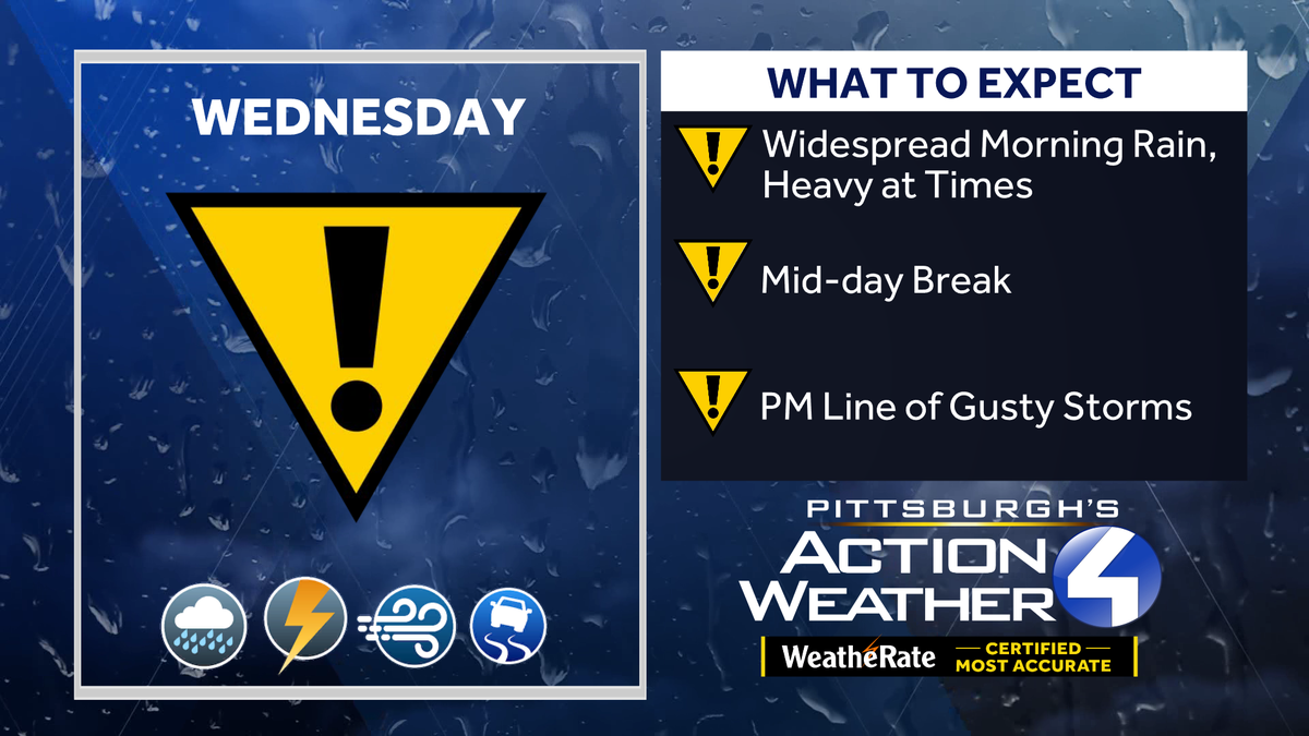
Isolated storms with gusty winds for Western Pennsylvania, Pittsburgh area Wednesday
Rain returns late tonight. A line of isolated storms is possible Wednesday afternoon.
THE ERROR, AND THEY’LL BE THERE TO HELP IF NEEDED. THE NEXT TWO DAYS, FEATURING EVERYTHING THE SPRING CAN OFFER HERE IN WESTERN PENNSYLVANIA, STARTS WITH THOSE FROSTY CONDITIONS THIS MORNING, FOLLOWED BY SUNSHINE, A NICE LITTLE WARM UP WEDNESDAY, OUR IMPACT DAY RAIN IN THE MORNING WILL BE FOLLOWED UP BY AN ISOLATED CHANCE FOR SOME STRONGER THUNDERSTORMS INTO THE AFTERNOON. RIGHT NOW, FROST AND FREEZE ALERTS DO CONTINUE THROUGH 8:00 THIS MORNING. STILL, TEMPERATURES CONTINUE TO TREND DOWNWARD, SO STILL COULD SEE SOME FROST FORMING HERE OVER THE NEXT SEVERAL HOURS. FREEZE WARNING CLOSER TO 422. MEANWHILE, ALLEGHENY COUNTY, THOSE AREAS TO THE SOUTH INCLUDED IN THE FROST ADVISORY. YOU CAN SEE TEMPERATURES ARE MUCH CHILLIER THE FARTHER NORTH YOU GO, JUST CLICKING DOWN TO 35 AND CONTAINING COLD SPOT RIGHT NOW AT CLARION AT 33, MEANWHILE, IS 45 IN PITTSBURGH. AS WE ARE GETTING THE BENEFIT OF SOME CLOUDS, AT LEAST EARLY ON THIS MORNING. BUT A LOT OF THAT CLOUD COVER WILL BE MIXING OUT JUST AS THE SUN WAKES UP THIS MORNING. PLENTY OF SUNSHINE ON TAP FOR YOUR TUESDAY. AFTER THIS FROSTY START. WE’LL SEE A VERY COMFORTABLE AFTERNOON WITH A HIGH OF 71. WE GET TO OUR IMPACT DAY TOMORROW IN YOUR 4-DAY PLUS 4 MORE FORECAST. ONCE WE DITCH THE RAIN AND STORMS, TEMPERATURES TEMPORARILY COOL OFF ON THURSDAY, BUT THEN CHECK OUT THE SECOND HALF OF THE WEEK STRAIGHT THROUGH THE START OF NEXT WEEK, AS WE WILL SEE MORE OF A SUMMER SURGE COMING OUR WAY. FINALLY, LET’S TALK ABOUT THIS IMPACT DAY. INCREASING CLOUDS DURING THE FIRST PART OF THE NIGHT AS EARLY AS MIDNIGHT. SOME AREAS CLOSER TO I-80 COULD START TO SEE SOME OF THAT RAIN HERE 6 A.M. TOMORROW. THAT WIDESPREAD SWATH OF RAIN STARTING TO BUILD IN MIXED IN SOME POCKETS OF DOWNPOURS THAT CERTAINLY COULD SLOW YOU DOWN AS EVERYBODY IS WAKING UP, GETTING OUT THE DOOR. THIS INITIAL PHASE OF OUR IMPACT DAY SHOULD BE CLEARING OUT. THIS IS THE MORNING COMMUTE IS WINDING DOWN. YOU CAN SEE THAT LINE OF SHOWER ACTIVITY ALREADY STARTING TO PULL CLOSER TO WAYNESBORO, UNIONTOWN, JUST OUTSIDE GREENSBURG, EVEN HEADING UP INTO THE HIGHER TERRAIN OF INDIANA COUNTY. A BIT OF A LULL THROUGH THE EARLY AFTERNOON. STILL A BIT OF A QUESTION MARK. IF WE HAPPEN TO SQUEEZE IN SOME SUNSHINE. IF WE DO, THAT COULD GIVE THE ATMOSPHERE A LITTLE EXTRA POP AS A SECONDARY LINE. FORMS MIXED IN NOT ONLY SOME HEAVY RAIN, BUT POSSIBLY A LOW END RISK FOR SOME ISOLATED STRONG TO SEVERE THUNDERSTORMS. I THINK A GREATER CHANCE FARTHER TO THE SOUTH AND EAST, WHERE WE HAVE A LITTLE BIT MORE TIME FOR THE ATMOSPHERE TO RECOVER. BUT OVERALL, EVERYBODY IN WESTERN PENNSYLVANIA INCLUDED IN TOMORROW’S ISOLATED SEVERE RISK. OVERALL, ONLY DAMAGING WINDS WILL BE A CONCERN. BUT STILL SOME HEAVY RAIN COULD LEAD TO SOME LOCALIZED FLOODING ISSUES. AS WE GO THROUGH THE SECOND HALF OF THE DAY. AGAIN, TEMPORARY SET BACK IN THE TEMPERATURES ON THURSDAY, ONLY 58. THEN OUR WARMING TREND TAKES OVER IN YOUR 4-DAY PLUS 4 MORE FORECAST 80S FOR THE WEEKEND, WE’LL KEEP AN EYE OUT FOR A STRAY SHOWER OR AFTERNOON RUMBLE OF THUNDER. THINGS SHOULD BE DRY IN THE MORNING FOR T
Isolated storms with gusty winds for Western Pennsylvania, Pittsburgh area Wednesday
Rain returns late tonight. A line of isolated storms is possible Wednesday afternoon.

Updated: 7:11 AM EDT May 12, 2026
Following a day of warmth and sunshine, Wednesday will bring back gusty storms into Western Pennsylvania’s forecast for an Impact Day. Impact Day Wednesday: Rain and isolated stormsWidespread rain will arrive late tonight and continue through tomorrow’s morning commute. Pockets of heavy rain are possible. We are tracking a break in the action between late morning and the early afternoon hours.Phase two of Wednesday’s Impact Day will feature of line of storms that could feature isolated severe weather. Damaging winds are the only concern. The best storm chances for southern counties through late afternoon.Summer swing by the weekendIsolated showers will linger Thursday with a cooler feel to the air. A warming trend begins on Friday. Temperatures will trend more summer-like starting this weekend. We could see isolated showers or storms. But most of Saturday and Sunday will be dry.TODAY: Frosty start, mild finish with sunshine. High: 71°.TONIGHT: Increasing clouds with rain after midnight. Low: 55°.WEDNESDAY – Impact Day: Morning rain, isolated afternoon storms. Windy. High: 68°, low: 46°.THURSDAY: Cooler with isolated showers. High: 58°, low: 42°.FRIDAY: More seasonal with sun and clouds. High: 67°, low: 52°.
Following a day of warmth and sunshine, Wednesday will bring back gusty storms into Western Pennsylvania’s forecast for an Impact Day.
Impact Day Wednesday: Rain and isolated storms
Widespread rain will arrive late tonight and continue through tomorrow’s morning commute. Pockets of heavy rain are possible. We are tracking a break in the action between late morning and the early afternoon hours.
Hearst OwnedHearst
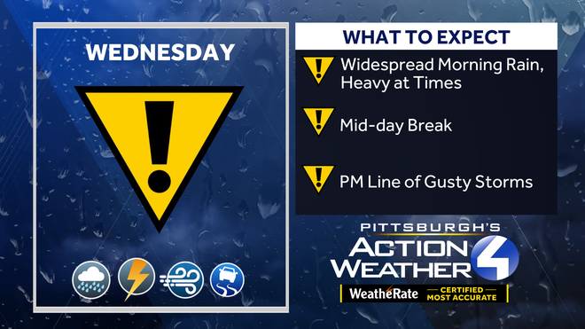
Wednesday’s Impact Day will feature two rounds of activity: morning rain, then a line of isolated storms after a mid-day lull.
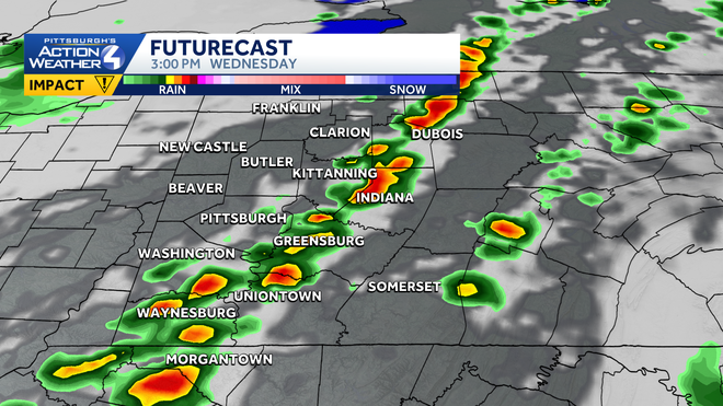
Phase two of Wednesday’s Impact Day will feature of line of storms that could feature isolated severe weather. Damaging winds are the only concern. The best storm chances for southern counties through late afternoon.
Hearst OwnedHearst
A line of isolated thunderstorms tracks across western PA Wednesday afternoon. The severe threat is low.
Summer swing by the weekend
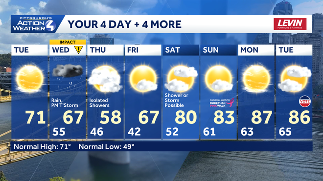
Isolated showers will linger Thursday with a cooler feel to the air. A warming trend begins on Friday. Temperatures will trend more summer-like starting this weekend. We could see isolated showers or storms. But most of Saturday and Sunday will be dry.
Hearst OwnedHearst
Temperatures start heating up this weekend.
TODAY: Frosty start, mild finish with sunshine. High: 71°.
TONIGHT: Increasing clouds with rain after midnight. Low: 55°.
WEDNESDAY – Impact Day: Morning rain, isolated afternoon storms. Windy. High: 68°, low: 46°.
THURSDAY: Cooler with isolated showers. High: 58°, low: 42°.
FRIDAY: More seasonal with sun and clouds. High: 67°, low: 52°.