

SHORT TERM FORECAST
TONIGHT: Increasing clouds. Low: 49
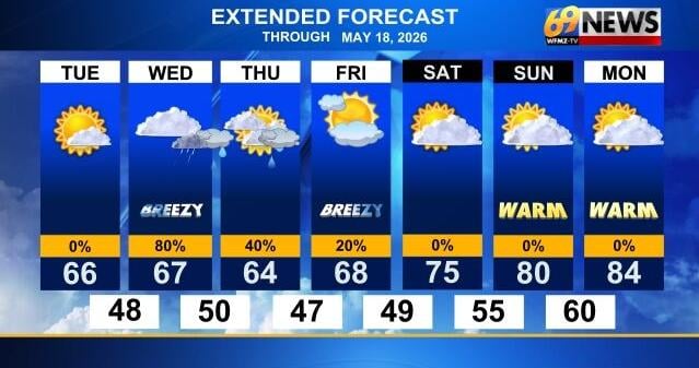
WEDNESDAY: Mostly cloudy and breezy with showers, especially later in the day. High: 70
WEDNESDAY NIGHT: Showers likely with an evening t-storm possible. Low: 51
FORECAST SUMMARY
While it was a chilly start to our Tuesday, with near or below freezing temperatures in the Poconos and upper 30s to near 40 degrees for everyone else, abundant sunshine made for a pleasant day weather-wise. Afternoon highs reached the mid 60s, still a bit cool for this of year, but something we’ll make up for by the upcoming weekend. A major warm up begins on Saturday and peaks early next week, with widespread 80-something-degree highs expected Sunday through Tuesday, and 90° highs aren’t out the question within that stretch either. Before the warmth arrives, we do have a little wet weather to get through first on Wednesday. It certainly won’t be a washout, but some afternoon and overnight showers (and perhaps a t-storm) should deliver around a ¼ to a ½ inch of rain to much of the area, the only chance of widespread rain in the forecast. A few scattered showers may linger Thursday, mainly over New Jersey, then we’ll await a surge of warmth, the warmest weather we will have seen since the middle of April.
DETAILED FORECAST
TONIGHT
It won’t be nearly as chilly tonight as it was last night, due in part to a milder southerly breeze, and in part to increasing clouds. It will be a good 10+ degrees warmer than last night for most of us, with lows in the upper 40s to around 50 degrees as skies trend mostly cloudy.
WEDNESDAY
Wednesday will bring the highest rain chances of the week, but won’t be a soaker or a washout. In fact, most of the wet weather should hold off until very late in the day on Wednesday, and even more so Wednesday evening into the overnight. Expect a mostly cloudy and breezy day, with slightly milder highs near 70 degrees. A shower or two is possible in the morning through mid-afternoon, though much of the time looks dry. The best chance for a few rounds of showers and an embedded thunderstorm will arrive from late afternoon through the evening hours, with the time frame from sunset to midnight probably the wettest. Showers should taper off towards morning on Thursday, with around a quarter of an inch of rain on average, and up to a half inch if you see a downpour or thunderstorm.
THURSDAY AND FRIDAY
As our low pressure shifts east to New England, perhaps slowing a bit, the wettest weather will be in the rearview mirror and to our east. However, that low will stall and slow close enough to give us some lingering clouds and at least the chance for a few showers on Thursday, but mostly focused in New Jersey, with mainly drier weather back west in PA. While clouds linger, there should be some sun at times, so let’s go partly sunny both Thursday and Friday, with just that small shower chance east of the Lehigh Valley. It will remain cooler than average (average high for this week is 73°), with highs in the mid 60s on Thursday, and upper 60s on Friday, but mostly dry both days.
THIS WEEKEND
It’s always nice when the weekend is the nicest part of the forecast, and that may be the case for the upcoming weekend. It’s certainly the warmest part of the forecast, with highs climbing into the upper 70s to near 80 degrees on Saturday, and inching up ever warmer into the low 80s on Sunday. Right now, it also looks dry, so you can fully enjoy a surge of warmth that perfectly coincides with the weekend.
MONDAY AND TUESDAY
This is when the core of the warmth arrives, with summer-like highs around 85-90 degrees expected both Monday and Tuesday. Expect warm to even hot summery sunshine both days, as we await a cold front to drop south and potentially cool us off by the middle of the week, but not until Wednesday at the earliest. Right now, a Tuesday night cold front seems most likely, with the best chance of any showers and storms immediately out ahead of that front later Tuesday or Tuesday night.
TRACK THE WEATHER:
LINKS: HOUR BY HOUR | RADAR | TRAFFIC