
IMPACT: Thunderstorms, brief heavy rain to hit south-central Pennsylvania
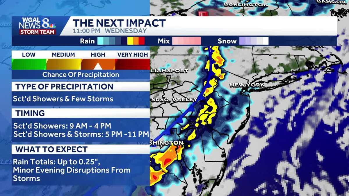
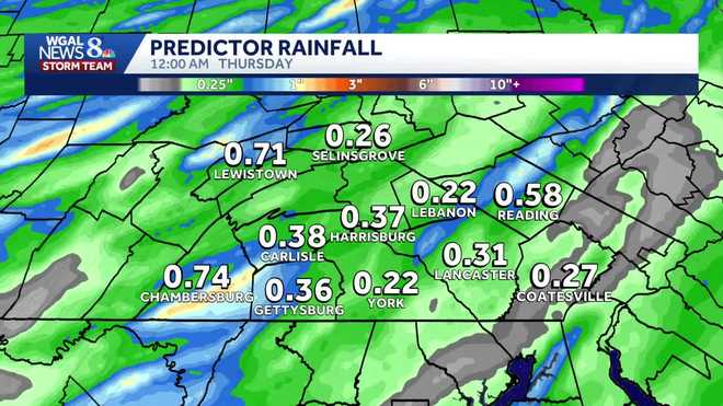
TEAM FORECAST WITH CHIEF METEOROLOGIST CHRISTINE FERREIRA. GOOD MORNING. IT IS 521. THE STORM PREDICTION CENTER HAS PUT PARTS OF THE SUSQUEHANNA VALLEY IN A VERY LOW RISK FOR ANY SEVERE WEATHER THIS AFTERNOON AND THIS EVENING, IT’S MAINLY WEST OF THE SUSQUEHANNA RIVER. TOWARD EVENING AFTER 5 P.M. THAT WE COULD SEE THE WINDOW OF OPPORTUNITY FOR SOME STORMS THAT MAY PRODUCE ISOLATED, DAMAGING WIND GUSTS, BUT THAT’S ABOUT IT FOR OUR THREATS TODAY. SO 5 P.M. TO 11 P.M., MOVING WEST TO EAST, A LINE OF SHOWERS AND THUNDERSTORMS WILL DEVELOP. ISOLATED DAMAGING WIND GUSTS, BRIEF HEAVY RAIN AND SOME LIGHTNING. WITH THIS. SO ON THIS IMPACT DAY, LET’S TAKE A LOOK AT OUR PREDICTOR THIS MORNING. WE’RE STARTING OUT MAINLY DRY. THERE WERE A FEW SHOWERS OVERNIGHT. THEY’RE LIFTING OFF TO THE NORTHEAST. I WON’T RULE OUT A FEW BREAKS OF SUN IN THE SOUTHEASTERN COUNTIES, BUT GENERALLY MOSTLY CLOUDY AS WE HEAD INTO THE AFTERNOON. LOOK AT THIS. AROUND LUNCHTIME. THERE’S A COUPLE OF SHOWERS HERE AND THERE. JUST A QUICK LITTLE SPLASH AND DASH SHOWER. NOTHING SEVERE TO BE CONCERNED WITH. HOWEVER, AS WE HEAD TOWARD EVENING, THIS IS WHERE THE REAL IMPACT OF THE DAY WHEN WE COULD POTENTIALLY SEE SOME HEAVIER RAIN, SOME GOOD DOWNPOURS THERE. A NICE SOAKING FOR THE DROUGHT, BUT IT COULD DISRUPT YOUR EVENING PLANS, ESPECIALLY IF YOU SEE SOME OF THIS HEAVY RAIN ROLLING THROUGH AND SOME RUMBLES OF THUNDER. SO SELINSGROVE, HARRISBURG, BACK TOWARD CHAMBERSBURG AND GETTYSBURG, YOU’LL SEE THAT AROUND ABOUT 7 P.M. IT WILL MOVE EAST AS SOON AS THE SUN GOES DOWN. SO IF YOU’RE IN LEBANON, LANCASTER, BACK TOWARD YORK, YOU’LL LIKELY SEE IT MORE TOWARDS SUNSET THIS EVENING. AND THEN THE STORMS WEAKEN AS THEY HEAD OFF TO THE EAST. BY ABOUT 11 P.M. WE’RE DONE WITH THE RAIN. SO HERE’S OUR NEWS. EIGHT STORM TEAM FORECAST TODAY. STARTING OUT MOSTLY CLOUDY WITH INCREASING CLOUDS THIS MORNING. COUPLE OF SHOWERS OUT THERE. A SPOTTY SHOWER THIS AFTERNOON. WE GET TO 68. IT’S THE EVENING WHERE THE IMPACTS BEGIN FOR SCATTERED THUNDERSTORMS THAT COULD PRODUCE BRIEF HEAVY RAIN AND ISOLATED DAMAGING WIND GUSTS WEST OF THE RIVER. TONIGHT, MOSTLY CLOUDY. ANY SHOWERS ARE OVER WITH. WE’LL DROP TO ABOUT 50 DEGREES WITH A LIGHT BREEZE OVERNIGHT, SO NOT TOO CONCERNED ABOUT ANY FOG FORMING UP TOMORROW. MOSTLY CLOUDY, LOW PRESSURE CRANKS UP, LIFTS UP OVER THE NORTHEAST AND THAT’S GOING TO PULL DOWN A COOL NORTHERLY WIND. SO IT WILL BE BREEZY TOMORROW. 10 TO 20MPH. HIGHS BARELY GET TO 60. SOME SPOTS MAY STAY IN THE 50S TOMORROW. RIGHT NOW WE HAVE A MIX OF 40S 50S ON THE TEMPERATURE MAP. IT IS A MILD MORNING COMPARED TO YESTERDAY. YESTERDAY WE WERE READING OFF 30. SO QUITE A CHANGE HERE WITH THIS WARM FRONT MOVING IN. WEATHER IN HEALTH REPORT TODAY. HIGH TREE POLLEN LEVELS STILL REMAIN. OUR AIR QUALITY IS LOOKING GOOD. UV INDEX MODERATE WITH A BURN TIME OF 40 TO 45 MINUTES. SO LOOK AT THIS. HERE’S THE WARM FRONT LIFTING NORTH THIS MORNING WITH JUST A FEW SHOWERS. REAL SPOTTY STUFF RIGHT NOW BACK TOWARD OHIO. THAT’S THE COLD FRONT. THAT’S GOING TO BE THE CULPRIT FOR OUR EVENING STORMS. SO IN BETWEEN TIME NOT MUCH GOING ON. THERE COULD BE A FEW SHOWERS HERE OR THERE. YOU SEE A COUPLE WEAK SHOWERS THIS AFTERNOON, BUT THE IMPACTS REALLY DO BEGIN THIS EVENING AS WE GET THOSE HEAVIER SHOWERS, THUNDERSTORMS THAT MOVE IN BETWEEN 5 P.M. AND 11 P.M. WEST TO EAST. TONIGHT WE DRY THINGS OUT, BUT THE CLOUDS, THEY HANG TOUGH. TOMORROW COULD SEE A FEW SPOTTY SHOWERS. IT’S GOING TO BE BREEZY. IT’S GOING TO BE COOL. THAT’S YOUR LAST 60 DEGREE DAY, THOUGH, BECAUSE BY THE TIME WE HIT FRIDAY, THAT AREA OF LOW PRESSURE LIFTS OUT. WE GET MORE BREAKS OF SUN ON FRIDAY AND MILDER AIR RETURNS. SO WE SHOULD BE UP NEAR 70 DEGREES. PREDICTOR ESTIMATED RAINFALL TOTALS FOR YOU FROM THIS SYSTEM THAT COMES IN THIS EVENING. MOST SPOTS ARE GOING TO PICK UP AROUND A QUARTER OF AN INCH TO A HALF INCH OF RAIN. SO A GOOD, NICE SOAKING FOR US, HELPING OUT OUR DROUGHT SITUATION. HERE’S THE TEN DAY FORECAST. WE ARE LOOKING AT TEMPERATURES NEAR 80. BELIEVE IT OR NOT, ON SATURDAY WE BUMP THAT UP FOR YOU. SUNDAY 84 DEGREES. SATURDAY OR SUNDAY MAY FEATURE A STRAY SHOWER, SO WE’LL KEEP YOU UPDATED NEXT WEEK. SUMMERLIKE WARMTH REGINA. WE ARE CRANKING IT WAY UP. I WOULDN’T BE SHOCKED TO SEE SOME SPOTS NEAR 90 DEGREES, ESPECIALLY MONDA
IMPACT: Thunderstorms, brief heavy rain to hit south-central Pennsylvania

Updated: 5:36 AM EDT May 13, 2026
A cold front will bring multiple rounds of rain to south-central Pennsylvania on Wednesday, with the greatest impact expected during the evening hours. Impact WednesdayMORNING/AFTERNOON: A few light showers will move from west to east late Wednesday morning through early afternoon, roughly between 9 a.m. and 4 p.m. Highs will reach the mid-60s. EVENING: A cold front will move through on Wednesday evening, bringing a round of showers, brief heavy rain and rumbles of thunder. This second round is expected between 5 p.m. and 11 p.m.Isolated thunderstorms may produce damaging wind gusts, mainly west of the Susquehanna River. Marginal Risk Parts of Pennsylvania, west of the Susquehanna River, are under a marginal risk for severe thunderstorms on Wednesday. The risk is tied to a cold front moving east through the Ohio Valley and central Appalachians.A few storms could become strong enough to produce isolated damaging wind gusts.Widespread severe weather is not expected.Instability is expected to remain weak, which should limit the overall severe threat.However, there will be enough wind shear in place to support a low-end risk for stronger storms. Rain totals Most areas are expected to receive around 0.10 to 0.50 inches of rain. Some areas could see isolated higher totals. What to WatchLight showers during the day are not expected to cause major issues.The evening round has the better chance for heavier rain and a few stronger storms.Areas west of the Susquehanna River face the greatest risk for isolated damaging wind gusts. Below: Predictor of rain chances across south-central Pa.SOUTH-CENTRAL PA WEATHER RESOURCES: INTERACTIVE RADAR | ACTIVE WEATHER ALERTS | CURRENT CONDITIONS | HOURLY FORECAST | 10-DAY FORECAST | WEEKEND FORECAST | MAP ROOM | DOWNLOAD THE APP | WEATHER EMAILS
A cold front will bring multiple rounds of rain to south-central Pennsylvania on Wednesday, with the greatest impact expected during the evening hours.
Impact Wednesday
MORNING/AFTERNOON:
A few light showers will move from west to east late Wednesday morning through early afternoon, roughly between 9 a.m. and 4 p.m. Highs will reach the mid-60s.
EVENING:
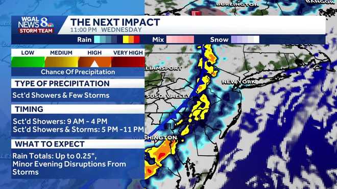
A cold front will move through on Wednesday evening, bringing a round of showers, brief heavy rain and rumbles of thunder. This second round is expected between 5 p.m. and 11 p.m.Isolated thunderstorms may produce damaging wind gusts, mainly west of the Susquehanna River.
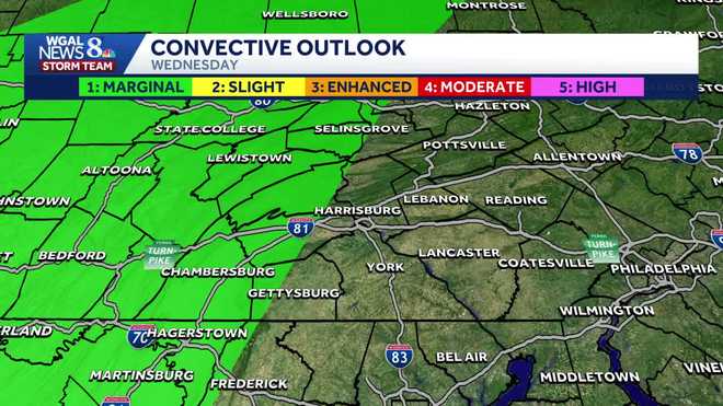
Marginal Risk Parts of Pennsylvania, west of the Susquehanna River, are under a marginal risk for severe thunderstorms on Wednesday. The risk is tied to a cold front moving east through the Ohio Valley and central Appalachians.A few storms could become strong enough to produce isolated damaging wind gusts.Widespread severe weather is not expected.Instability is expected to remain weak, which should limit the overall severe threat.However, there will be enough wind shear in place to support a low-end risk for stronger storms.
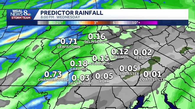
Rain totals Most areas are expected to receive around 0.10 to 0.50 inches of rain. Some areas could see isolated higher totals.
What to WatchLight showers during the day are not expected to cause major issues.The evening round has the better chance for heavier rain and a few stronger storms.Areas west of the Susquehanna River face the greatest risk for isolated damaging wind gusts.
Below: Predictor of rain chances across south-central Pa.
SOUTH-CENTRAL PA WEATHER RESOURCES: INTERACTIVE RADAR | ACTIVE WEATHER ALERTS | CURRENT CONDITIONS | HOURLY FORECAST | 10-DAY FORECAST | WEEKEND FORECAST | MAP ROOM | DOWNLOAD THE APP | WEATHER EMAILS