
Few showers today; scattered evening thunderstorms in south-central Pennsylvania
Evening storms may produce isolated gusty winds and brief, heavy rain. Showers will end overnight, then isolated shower chances on tap for tomorrow afternoon. A big warmup is in store for the upcoming weekend!
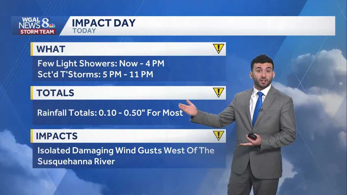
SUNCATCHER. NOW, THE WGAL NEWS EIGHT STORM TEAM FORECAST WITH METEOROLOGIST RYAN ARGENTI STORM TEAM LIVE RADAR NETWORK AT THIS TIME SHOWING SOME SHOWERS THAT ARE BEGINNING TO ROLL THROUGH THE SUSQUEHANNA VALLEY. SEE SOME POCKETS OF SOME MODERATE SHOWERS MOVING IN ON FRANKLIN COUNTY. STARTING TO CLOSE IN ON CUMBERLAND COUNTIES, AS WELL AS GETTING INTO OUR MORE NORTHERN COMMUNITIES. SO WE’RE GOING TO CONTINUE TO SEE THE CHANCES OF A FEW SHOWERS LATER THIS AFTERNOON AND EVENING. BUT THIS EVENING WE ARE EXPECTING SOME STORMS WE HAVE. TODAY IS AN IMPACT DAY. SO LET’S TIME IT OUT FOR YOU. SO CLOSER TO THE TIME STAMP. BY THE WAY, LOOK AT THIS RIGHT AROUND FIVE, 6:00 IN THE EVENING. THAT’S WHEN WE’LL START TO SEE THIS LINE OF SOME STORMS BEGIN TO MOVE THROUGH AND SOME HEAVIER POCKETS OF SOME MODERATE OR HEAVIER POCKETS OF SOME SHOWERS WILL MOVE INTO THE AREA. SO YOU CAN SEE CLOSER TOWARDS YORK AND DAUPHIN COUNTIES, CUMBERLAND COUNTIES CLOSING IN ON LEBANON COUNTY RIGHT AROUND 7:00 THIS EVENING. THEN CLOSER TO ABOUT 10:00 TONIGHT, WE’LL SEE THOSE STORMS BEGIN TO WILL START TO WEAKEN, BUT WE’LL STILL BE SEEING SOME SHOWERS CLOSER TO ABOUT 10 OR 11:00 TONIGHT. AND THEN ONCE WE GET INTO THE OVERNIGHT PERIOD, THOSE SHOWERS WILL HAVE MOVED OUT. WE’LL STILL SEE PARTLY TO MOSTLY CLOUDY CONDITIONS THOUGH AS WE HEAD INTO AS WE HEAD INTO TONIGHT. SO FROM NOW UNTIL 4:00 IN THE AFTERNOON, WE’LL SEE A FEW MORE. WE’LL SEE A FEW LIGHT SHOWERS LIKE WE’RE SEEING. THEN WE’LL SEE THOSE THUNDERSTORMS START TO MOVE IN CLOSER TO ABOUT FIVE. WE’RE FROM 5:00 TILL 11:00 AT NIGHT. WE’LL SEE ABOUT A 10TH TO ABOUT A HALF INCH OF SOME RAIN FOR MOST AREAS. BUT WE COULD SEE SOME ISOLATED DAMAGING WIND GUSTS FOR COMMUNITIES THAT ARE WEST OF THE SUSQUEHANNA RIVER. SO FORECAST FOR THE REST OF THE DAY TODAY. EXPECT A FEW OF THOSE SHOWERS AND THUNDERSTORMS REMAINING MOSTLY CLOUDY. WE HAVE THAT IMPACT ICON THERE FOR THE CHANCE OF WAR, FOR THE LOW CHANCE OF ANYTHING SEVERE HAPPENING TODAY. BUT FOR TONIGHT, MOSTLY CLOUDY. WE’LL SEE THOSE SHOWERS ENDING. WE’LL SEE A LIGHT BREEZE OUT OF THE NORTHWEST BETWEEN 5 AND 15MPH, 48 TO 52 DEGREES. THEN WE’LL RISE TO THE 60S FOR TOMORROW, BUT WE’LL SEE A CHANCE OF A FEW ISOLATED SHOWERS FOR THE AFTERNOON. NOW, WEATHER FOR THE DAY TODAY. TREE POLLEN LEVELS REMAINING HIGH. LOW MOLD LEVELS. GOOD AIR QUALITY. MODERATE UV INDEX. GOT ABOUT A 45 MINUTE BURN TIME. BUT WE’RE INTO THE 60S NOW FOR HARRISBURG, 69 IN YORK, 68 IN LANCASTER, 72 IN LEBANON AND GETTYSBURG AT THIS TIME. AND WE HAVE A LITTLE BIT OF A BREEZE OR A LIGHT BREEZE COMING IN FROM THE SOUTH, BUT THAT’S JUST ALLOWING FOR SOME OF THAT WARMER AIR TO START TO COME IN TO THE SUSQUEHANNA VALLEY. SO HERE ARE A FEW OF THOSE SHOWERS MOVING THROUGH, BUT I DO HAVE MY EYE ON THIS COLD FRONT. THE COLD FRONT JUST DRAPED OVER LAKE ERIE RIGHT NOW. THAT’S WHAT’S HELPING TO SET OFF SOME OF THESE STORMS TOWARDS ERIE AT THIS AT THIS HOUR. BUT ONCE THAT COLD FRONT MOVES THROUGH, WE’LL SEE THOSE SHOWERS. WE’LL SEE SHOWER CHANCE LATER FOR THURSDAY AND AN ISOLATED SHOWER CHANCE FOR LATER IN THE AFTERNOON. YOU CAN SEE TOWARDS 330, 4:00 IN THE AFTERNOON. TOMORROW A COUPLE ISOLATED SHOWERS, BUT THEN WE’RE LOOKING AT PARTLY SUNNY CONDITIONS ONCE WE GET INTO EARLY FRIDAY AND ALSO GETTING INTO OUR FRIDAY EVENING. SO YOU CAN SEE JUST REALLY PARTLY SUNNY CONDITIONS. BUT FROM THIS SYSTEM THAT’S GOING TO PUSH THROUGH THIS COLD FRONT, WE’RE REALLY SEEING, LIKE I MENTIONED, ABOUT A 10TH OF A 10TH OF A 10TH OF AN INCH OF SOME RAIN, EVEN A HALF INCH OF SOME, SOME RAIN, MAYBE ISOLATED SPOTS GET UPWARDS OF HALF INCH, MAYBE THREE QUARTERS OF AN INCH. BUT THAT’S LOOKING ISOLATED AT THIS TIME. SO IN FACT, A SET FOR TODAY FOR THOSE SCATTERED AFTERNOON STORMS, BREEZY AND COOLER FOR THURSDAY. BUT LOOK AT THIS GETTING TO THE 70S FOR FRIDAY, GETTING TO THE 80S FOR SATURDAY AND SUNDAY.
Few showers today; scattered evening thunderstorms in south-central Pennsylvania
Evening storms may produce isolated gusty winds and brief, heavy rain. Showers will end overnight, then isolated shower chances on tap for tomorrow afternoon. A big warmup is in store for the upcoming weekend!

Updated: 12:32 PM EDT May 13, 2026
IMPACT WEDNESDAY:Ahead of a cold front, clouds will increase, and a few light showers will move west to east this morning and afternoon. Highs will reach the upper 60s.The cold front will arrive this evening, with another round of showers and thunderstorms. Expect brief, heavy rain and rumbles of thunder between 5 p.m. and 11 p.m. Isolated thunderstorms may produce damaging wind gusts, mainly west of the Susquehanna River. Rain totals will be around a tenth of an inch to 0.50″ for most of the area.Tonight, showers will end, and the sky will remain mostly cloudy, with lows near 50 and a light breeze.END OF THE WEEK:As low pressure moves into the Northeast, Thursday will be mainly cloudy, with spotty showers and highs around 60 degrees. A 10-20 mph northwesterly breeze will make if feel cool.By Friday, temperatures will rebound to 70 degrees under partly sunny skies.Temperatures trend warmer this weekend. Expect highs near 80 Saturday, and 84 Sunday. Both days look mainly dry with a mix of clouds and sunshine.NEXT WEEK:Summerlike warmth continues as temperatures reach the upper 80s Monday and Tuesday. It will even be a bit sticky, as dew points climb to the low 60s. There is a low chance for showers late Tuesday.Higher rain chances come with a cold front Wednesday. Temperatures will fall back to seasonable averages, in the low-to-mid 70s, at the end of the week. Isolated showers are possible Thursday and Friday.Have a great rest of your day!~ Ryan
IMPACT WEDNESDAY:
Ahead of a cold front, clouds will increase, and a few light showers will move west to east this morning and afternoon. Highs will reach the upper 60s.
The cold front will arrive this evening, with another round of showers and thunderstorms. Expect brief, heavy rain and rumbles of thunder between 5 p.m. and 11 p.m. Isolated thunderstorms may produce damaging wind gusts, mainly west of the Susquehanna River. Rain totals will be around a tenth of an inch to 0.50″ for most of the area.
Tonight, showers will end, and the sky will remain mostly cloudy, with lows near 50 and a light breeze.
END OF THE WEEK:
As low pressure moves into the Northeast, Thursday will be mainly cloudy, with spotty showers and highs around 60 degrees. A 10-20 mph northwesterly breeze will make if feel cool.
By Friday, temperatures will rebound to 70 degrees under partly sunny skies.
Temperatures trend warmer this weekend. Expect highs near 80 Saturday, and 84 Sunday. Both days look mainly dry with a mix of clouds and sunshine.
NEXT WEEK:
Summerlike warmth continues as temperatures reach the upper 80s Monday and Tuesday. It will even be a bit sticky, as dew points climb to the low 60s. There is a low chance for showers late Tuesday.
Higher rain chances come with a cold front Wednesday. Temperatures will fall back to seasonable averages, in the low-to-mid 70s, at the end of the week. Isolated showers are possible Thursday and Friday.
Have a great rest of your day!
~ Ryan