
Breezy and cooler, then warming up for the weekend and into next week in south-central Pennsylvania
Warmer conditions are expected for the weekend with temps getting to the 80s. Then feeling summerlike next week with temps rising to the 90s!
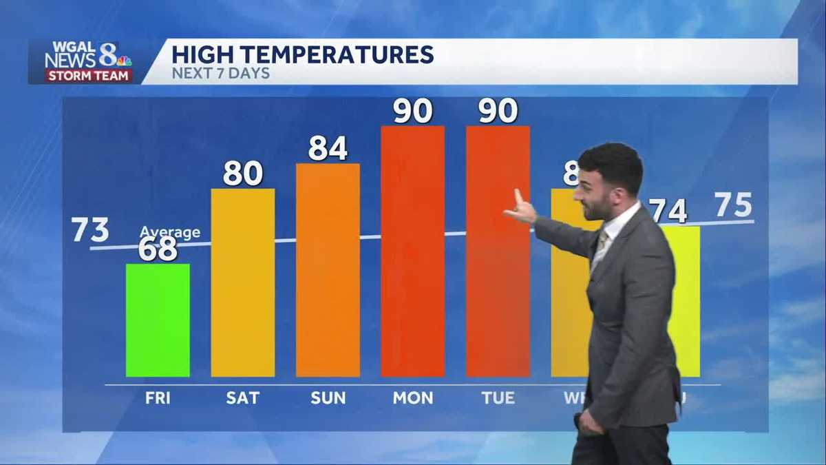
REMEMBER, PRIMARY DAY IS THIS COMING TUESDAY THE 19TH. NOW, THE WGAL NEWS EIGHT STORM TEAM FORECAST WITH METEOROLOGIST RYAN ARGENTI. MOST AREAS SO FAR THIS AFTERNOON HEADING INTO THE EVENING. STILL DRY, BUT I DO SEE A BIT OF AN ISOLATED SHOWER STARTING TO CLOSE IN TOWARDS UPPER DAUPHIN COUNTY MAY MAKE ITS WAY INTO UPPER LEBANON COUNTY HERE IN THE NEXT. IN THE NEXT 20 TO 30 MINUTES. BUT MOST OF THE AREAS YOU CAN SEE STILL REMAINING DRY. WE’LL CONTINUE TO WATCH THE SWATH OF SHOWERS THAT MAY COME IN, BUT WE ARE WE ARE EXPECTING ISOLATED SHOWERS FOR THE EVENING, BUT LOOKING AHEAD INTO OUR FRIDAY, IT WILL STILL BE BREEZY AND MILD, PARTLY SUNNY CONDITIONS 68 DEGREES WARMER FOR THE WEEKEND COMING UP, BUT I WANT TO DIRECT YOUR ATTENTION RIGHT ALONG HERE. LOOK AT THIS MONDAY GETTING INTO TUESDAY, GETTING INTO THE 90S. HOT AND STICKY IS WHAT IT’S GOING TO FEEL LIKE AS WE HEAD INTO NEXT WEEK. SO FOR THIS EVENING, MOSTLY CLOUDY, 54 DEGREES AND BREEZY. TONIGHT. MOSTLY CLOUDY. IT WILL REMAIN MOSTLY CLOUDY AND BREEZY. WE’LL HAVE TEMPERATURES DROP DOWN TO THE UPPER 40S AND THEN STILL REMAINING. I WOULD SAY A MIX OF SOME CLOUDS AND SUNSHINE. SO PARTLY SUNNY CONDITIONS FOR TOMORROW WILL BE BREEZY AND MILD TEMPERATURES GETTING INTO THE UPPER 60S. NOW I WANT TO I WANT TO TALK ABOUT THE DROUGHT MONITOR. WE JUST HAD THIS RELEASED EARLIER TODAY. AND UNFORTUNATELY, SINCE LAST WEEK, THE DROUGHT SITUATION HAS WORSENED. ACTUALLY, AS A MATTER OF FACT, THE SEVERE DROUGHT THRESHOLD HERE WAS PUSHED A LITTLE FURTHER NORTH. NOW, I WILL MAKE A NOTE THIS DOES NOT INCLUDE THE SHOWERS THAT WE RECEIVED LAST NIGHT FROM THE LINE OF STORMS THAT WE HAD COME THROUGH. NOTICE THE THE SUBHEADLINE HERE. THIS IS COLLECTED THROUGH TUESDAY MORNING, SO THE DATA. THE NEXT SET OF DATA IS GOING TO BE COLLECTED FOR. NEXT WEEK IS GOING TO STOP AT TUESDAY MORNING, AND WE’LL GET THE NEW PRODUCT NEXT THURSDAY. SO WE’LL SEE WHAT THOSE WHAT THE EFFECTS WERE FROM THAT. BUT IN TERMS OF THE RAINFALL THAT WE RECEIVED LAST NIGHT, STILL GOT A DECENT SOAKING, YOU SEE ABOUT JUST OVER 8/10 OF AN INCH IN HALIFAX OVER THE LAST 24 HOURS. MERCERSBURG, JUST SHY OF THAT HALF INCH MARK, 0.43IN IN QUARRYVILLE. LEWISTOWN JUST 4/10 OF AN INCH AND ABOUT 2/10 OF AN INCH IN BIGLERVILLE AND BIGLERVILLE IN ADAMS COUNTY. NOW, POLLEN LEVELS FOR THE TREES AND GRASS REMAINING HIGH FOR TOMORROW. MOLD LEVELS. LOW AIR QUALITY IS GOOD AND MODERATE UV INDEX GOT ABOUT A 30 MINUTE BURN TIME. THE NEXT BEST CHANCE OF SHOWERS LOOK TO BE LATE SATURDAY INTO EARLY SUNDAY. WE COULD BE SEEING SOME FEW SHOWERS AFTER DARK AND A FEW SHOWERS FOR OUR SUNDAY. NOW TEMPERATURES ARE INTO THE UPPER 50S FOR MOST AREAS AND STILL GOING TO CONTINUE TO WATCH THESE ISOLATED SHOWERS AS WE HEAD INTO THE EVENING. BUT ONCE WE GET INTO OUR FRIDAY, WE’LL START TO SEE SOME HIGH PRESSURE BEGIN TO DEVELOP AND START TO INFLUENCE SOME OF OUR CONDITIONS. AS LOW PRESSURE CONTINUES TO DEPART AND HIGH PRESSURE BUILDS IN FROM THE SOUTH, IT’S ACTUALLY GOING TO HELP CLEAR OUR SKIES ONCE WE GET INTO OUR LATE FRIDAY EVENING AND THEN HEADING INTO OUR SATURDAY, WE’LL STILL SEE A LITTLE BIT OF SOME CLOUD COVER, BUT HIGH PRESSURE WILL BEGIN TO TAKE OVER ONCE AGAIN. NOT ONLY WILL IT HELP TO CLEAR OUR SKIES, BUT IT’S GOING TO BE BUMPING THOSE TEMPERATURES UP INTO THE 80S. YOU CAN SEE HERE SATURDAY, 80 DEGREES 80 FOUR, SUNDAY 90S FOR MONDAY AND TUESDAY OF NEXT WEEK. AND AS WE GET INTO NEXT WEEK FOR THE MIDDLE OF THE WEEK, WE ARE LOOKING AT THE CHANCE FOR SOME SHOWERS AND POSSIBLE STORMS. 80 DEGREES FOR YOUR WEDNESDAY,
Breezy and cooler, then warming up for the weekend and into next week in south-central Pennsylvania
Warmer conditions are expected for the weekend with temps getting to the 80s. Then feeling summerlike next week with temps rising to the 90s!

Updated: 4:29 PM EDT May 14, 2026
Mostly cloudy skies today and isolated showers, as low pressure moves into the Northeast. A 10-20 mph northwesterly breeze will make if feel unseasonably cool. Expect highs in the upper 50s.Tonight, lows will fall to the upper 40s under mostly cloudy skies. 10-20 mph winds will continue, as low pressure pulls away.Clouds hang around Friday morning, then we’ll see breaks of sun, boosting highs to the upper 60s. The breeze will diminish by evening.Temperatures trend warmer this weekend. Expect highs near 80 Saturday, and 84 Sunday. Spotty showers are possible late Saturday, and a few showers are possible Sunday.Summerlike warmth is in store early next week, as highs soar to 90 degrees Monday and Tuesday, but records are not in jeopardy. It will even be a bit sticky Tuesday, as dew points climb to the low 60s. A shower is possible late Tuesday.Higher rain chances come with a cold front Wednesday. Temperatures will remain above average, near 80 degrees.Temperatures will fall back to seasonal averages, in the low 70s, at the end of the week. Chances for showers linger Thursday through Saturday.
Mostly cloudy skies today and isolated showers, as low pressure moves into the Northeast. A 10-20 mph northwesterly breeze will make if feel unseasonably cool. Expect highs in the upper 50s.
Tonight, lows will fall to the upper 40s under mostly cloudy skies. 10-20 mph winds will continue, as low pressure pulls away.
Clouds hang around Friday morning, then we’ll see breaks of sun, boosting highs to the upper 60s. The breeze will diminish by evening.
Temperatures trend warmer this weekend. Expect highs near 80 Saturday, and 84 Sunday. Spotty showers are possible late Saturday, and a few showers are possible Sunday.
Summerlike warmth is in store early next week, as highs soar to 90 degrees Monday and Tuesday, but records are not in jeopardy. It will even be a bit sticky Tuesday, as dew points climb to the low 60s. A shower is possible late Tuesday.
Higher rain chances come with a cold front Wednesday. Temperatures will remain above average, near 80 degrees.
Temperatures will fall back to seasonal averages, in the low 70s, at the end of the week. Chances for showers linger Thursday through Saturday.