
A significant warm-up is headed for south-central Pennsylvania, with temperatures surging from the upper 60s on Friday to the low and mid-90s by early next week. Monday is expected to bring the region’s first 90-degree day of the year, with even hotter weather likely on Tuesday.That’s well above average, as the normal high for both days is 74 degrees. From spring chill to summer heatAfter a cool end to the workweek, temperatures will rise quickly through the weekend and into next week:Friday: 68 degreesSaturday: 80 degreesSunday: 84 degreesMonday: 90 degreesTuesday: 92 degreesWednesday: 86 degreesThe warmest day so far this year was 88 degrees on April 16. Records could be challengedWhile daytime record highs do not appear to be in serious jeopardy, some unusually warm overnight lows could be challenged. In Harrisburg, the forecast high is 90 on Monday, compared with the record of 94 set in 1962. Tuesday’s forecast high is 92, below the record of 95, also set in 1962. Morning lows may be more notable:Tuesday | Forecast low: 68, Record low: 67Wednesday | Forecast low: 70, Record low: 67Notable early-season heatThe average first 90-degree day in the region is June 1, so this stretch is arriving a bit ahead of schedule.Still, it is far from the earliest on record. The earliest first 90-degree day on record was April 17, while the latest did not occur until July 30, 1917. The WGAL News 8 Storm Team will continue to track the forecast and provide updates. Did you capture a moment that you would like to share with News 8? Send us your photos or videos at https://www.wgal.com/upload.
A significant warm-up is headed for south-central Pennsylvania, with temperatures surging from the upper 60s on Friday to the low and mid-90s by early next week.
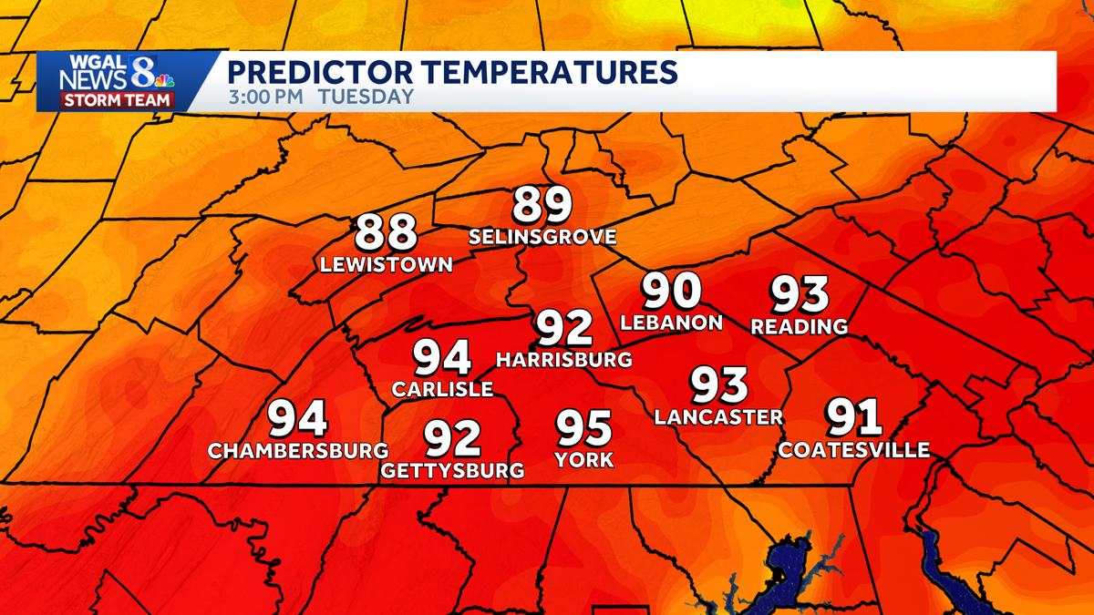
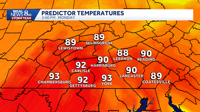
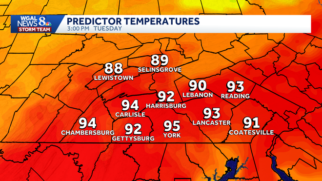
Monday is expected to bring the region’s first 90-degree day of the year, with even hotter weather likely on Tuesday.
That’s well above average, as the normal high for both days is 74 degrees.
This content is imported from Woobox.
You may be able to find the same content in another format, or you may be able to find more information, at their web site.
From spring chill to summer heat
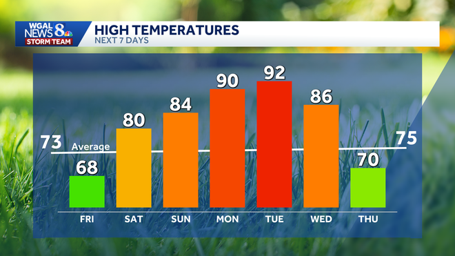
After a cool end to the workweek, temperatures will rise quickly through the weekend and into next week:
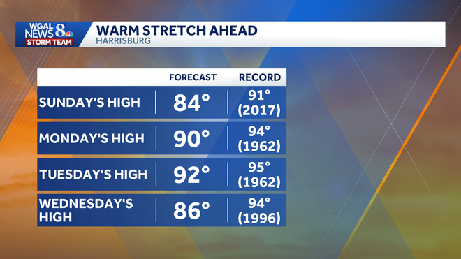
Friday: 68 degreesSaturday: 80 degreesSunday: 84 degreesMonday: 90 degreesTuesday: 92 degreesWednesday: 86 degrees
The warmest day so far this year was 88 degrees on April 16.
Records could be challenged
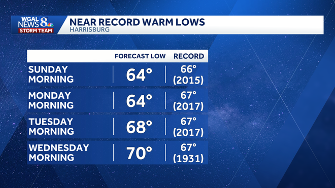
While daytime record highs do not appear to be in serious jeopardy, some unusually warm overnight lows could be challenged.
In Harrisburg, the forecast high is 90 on Monday, compared with the record of 94 set in 1962. Tuesday’s forecast high is 92, below the record of 95, also set in 1962.
Morning lows may be more notable:
Tuesday | Forecast low: 68, Record low: 67Wednesday | Forecast low: 70, Record low: 67
Notable early-season heat
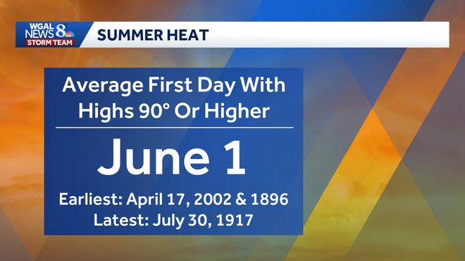
The average first 90-degree day in the region is June 1, so this stretch is arriving a bit ahead of schedule.
Still, it is far from the earliest on record. The earliest first 90-degree day on record was April 17, while the latest did not occur until July 30, 1917.
The WGAL News 8 Storm Team will continue to track the forecast and provide updates.
Did you capture a moment that you would like to share with News 8? Send us your photos or videos at https://www.wgal.com/upload.