
Pittsburgh: Warm weekend with showers Saturday
Highs return to the 80s this weekend.
YEAH, ESPECIALLY IF YOU’RE GOING TO BE SPENDING A LOT OF TIME IN THE NEXT FEW DAYS OUTSIDE. WE’RE GOING TO SEE A LOT OF SUNSHINE. WE’LL ADD IN A COUPLE OF RAIN CHANCES FOR US, MAINLY LATE ON SATURDAY. IT’S NOT A WASHOUT, BUT IF YOU ARE GOING TO BE OUTSIDE AROUND SUNSET, YOU’LL WANT TO MAKE SURE THAT YOU HAVE THE RAIN GEAR HANDY AND WE’LL CLEAR OUT THE CLOUDS ON SUNDAY. AND TEMPERATURES REALLY SKYROCKET ON MONDAY, OUR WARMEST DAY OF THE YEAR SO FAR LOOKS TO BE HERE FOR MONDAY AND THEN AGAIN ON TUESDAY. 81 IS WHERE WE MAKE IT TOMORROW WITH AGAIN THAT AFTERNOON SHOWER AND THUNDERSTORM CHANCE WE WILL DRY OUT ON SUNDAY. SUNSHINE RETURNS 8390 FOR MONDAY AND TUESDAY, SO IT’S GOING TO BE VERY WARM. WE WILL FEEL INCREASING HUMIDITY, BUT IT WON’T BE TERRIBLY MUGGY EITHER DAY. CLOUDS WILL INCREASE LATE ON TUESDAY AS A COLD FRONT GETS HERE WEDNESDAY. THAT WILL BRING RAIN SHOWERS. AND THAT KNOCKS US BACK TO MORE SEASONABLE LEVELS AS WE HEAD INTO THURSDAY AND FRIDAY, AS HIGH TEMPERATURES DROP BACK INTO THE LOWER 70S. THEN WE START WARMING AS WE HEAD INTO YOUR MEMORIAL DAY WEEKEND. BUT RIGHT NOW, THE START OF THE WEEKEND DOES LOOK DRY THIS WEEKEND. MOST OF THE WEEKEND IS DRY. THE CLOCK HERE AT 2:00 ON SATURDAY WE’LL SEE INCREASING CLOUDS. WE MAY SEE A STRAY SHOWER TRYING TO POP, BUT MOST OF THE RAIN CHANCES LIKELY HOLD OFF UNTIL WE GET CLOSER TO ABOUT SIX 7:00 OR SO. THAT’S WHAT WE COULD SEE. SOME SCATTERED SHOWERS AND A FEW ISOLATED RUMBLES OF THUNDER DEVELOP AT THIS POINT. NOT EXPECTING SEVERE WEATHER, BUT A THUNDERSTORM IS POSSIBLE. THIS RAIN WILL CONTINUE DRIFTING EASTWARD AS WE GET THROUGH THE EVENING HOURS. AS WE GET CLOSER TO MIDNIGHT, RAIN SHOULD TAPER OFF ACROSS WESTERN PENNSYLVANIA. CLOUDS WILL STAY WITH US THOUGH, AS WE START OUR SUNDAY, SO IT’S GOING TO BE MOSTLY CLOUDY OUT THE DOOR. AND THEN AS WE HEAD THROUGH THE MORNING HOURS, WE’LL START SEEING SUNSHINE RETURNING TO WESTERN PENNSYLVANIA. AS WE TURN PARTLY CLOUDY LATE IN THE DAY ON SUNDAY. AND THEN THAT WILL HOLD INTO YOUR MONDAY AS WELL. SO AGAIN, REALLY LATE SATURDAY IN A VERY EARLY SUNDAY IS THE BEST CHANCE TO SEE A SHOWER. BUT BECAUSE WE ARE GOING TO BE SO WARM MONDAY OR TUESDAY, WE MAY HAVE TO WATCH FOR JUST A STRAY SHOWER TRYING TO POP. THAT LOOKS UNLIKELY AT THIS POINT. SKIES HAVE SOME CLOUDS OUT THERE. MIX OF SUN AND CLOUDS ON ACTION. CAM 66 IS THE CURRENT TEMPERATURE. WINDS ARE CURRENTLY NORTH NORTHWEST AT FIVE MILES PER HOUR. IT’S GOING TO BE A PRETTY MILD NIGHT TONIGHT AS CLOUDS STAY WITH US AT LEAST EARLY WILL SLOWLY DROP OFF AS WE HEAD THROUGH THE DAY TOMORROW. AGAIN, WE’RE WARMING BACK TOWARDS THE LOWER 80S AS WE WATC
Pittsburgh: Warm weekend with showers Saturday
Highs return to the 80s this weekend.

Updated: 4:26 PM EDT May 15, 2026
We return to the 80s for the first time since April this weekend with 90 likely early next week.Summer Feel by the WeekendTemperatures will trend more summer-like starting this weekend. High temperatures for Saturday and Sunday should reach the lower 80s, which is where our average highs sit in June and July. We are watching for some late day showers and isolated storms on Saturday. Clouds will linger into early Sunday morning with clearing skies through the day.Highs Push 90, Seasonal by the end of the weekThe warmest day of the year so far is likely on Monday and again Tuesday as we make a run to 90 for the first time this year. Clouds will increase late on Tuesday as a cold front approaches, meaning the highest temperatures will be most likely for Pittsburgh and locations south and east.Rain chances return on Wednesday as a cold front arrives. Depending on timing, rain could get here as early as late on Tuesday. This cold front will also bring back more seasonal temperatures in the lower 70s to close out the week. As of now, we look to be dry for the start of the Memorial Day Weekend.TONIGHT: Partly to mostly cloudy. Low 49°.SATURDAY: Mostly cloudy with late day showers and storms possible. High: 81°, low: 62°.SUNDAY: Early morning showers then clouds decrease through the day. High: 83°, low: 64°.
PITTSBURGH —
We return to the 80s for the first time since April this weekend with 90 likely early next week.
Summer Feel by the Weekend
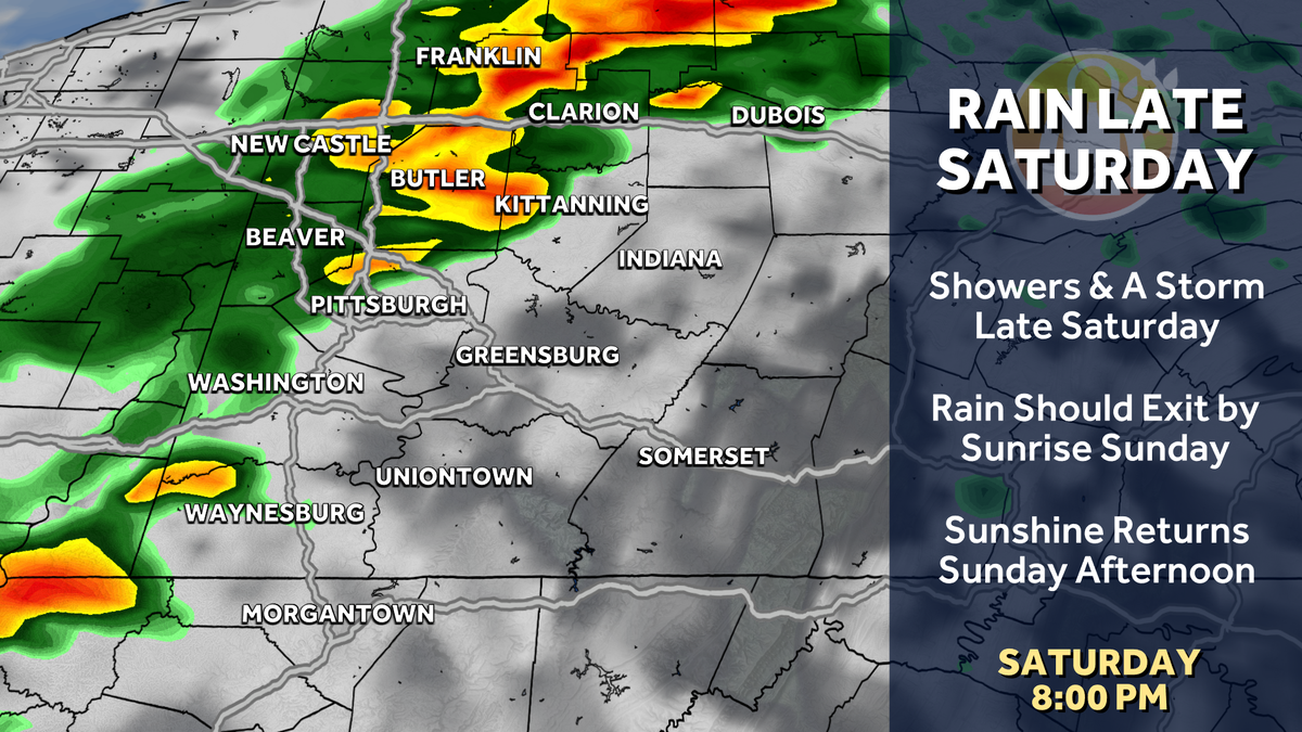
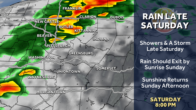
Temperatures will trend more summer-like starting this weekend. High temperatures for Saturday and Sunday should reach the lower 80s, which is where our average highs sit in June and July. We are watching for some late day showers and isolated storms on Saturday. Clouds will linger into early Sunday morning with clearing skies through the day.
Hearst Owned
Some showers and isolated storms are possible Saturday afternoon and evening.
Highs Push 90, Seasonal by the end of the week
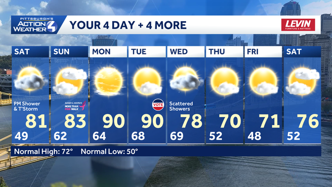
The warmest day of the year so far is likely on Monday and again Tuesday as we make a run to 90 for the first time this year. Clouds will increase late on Tuesday as a cold front approaches, meaning the highest temperatures will be most likely for Pittsburgh and locations south and east.
Rain chances return on Wednesday as a cold front arrives. Depending on timing, rain could get here as early as late on Tuesday. This cold front will also bring back more seasonal temperatures in the lower 70s to close out the week. As of now, we look to be dry for the start of the Memorial Day Weekend.
Hearst Owned
Feeling more like Summer for the weekend and start of next week.
TONIGHT: Partly to mostly cloudy. Low 49°.
SATURDAY: Mostly cloudy with late day showers and storms possible. High: 81°, low: 62°.
SUNDAY: Early morning showers then clouds decrease through the day. High: 83°, low: 64°.