
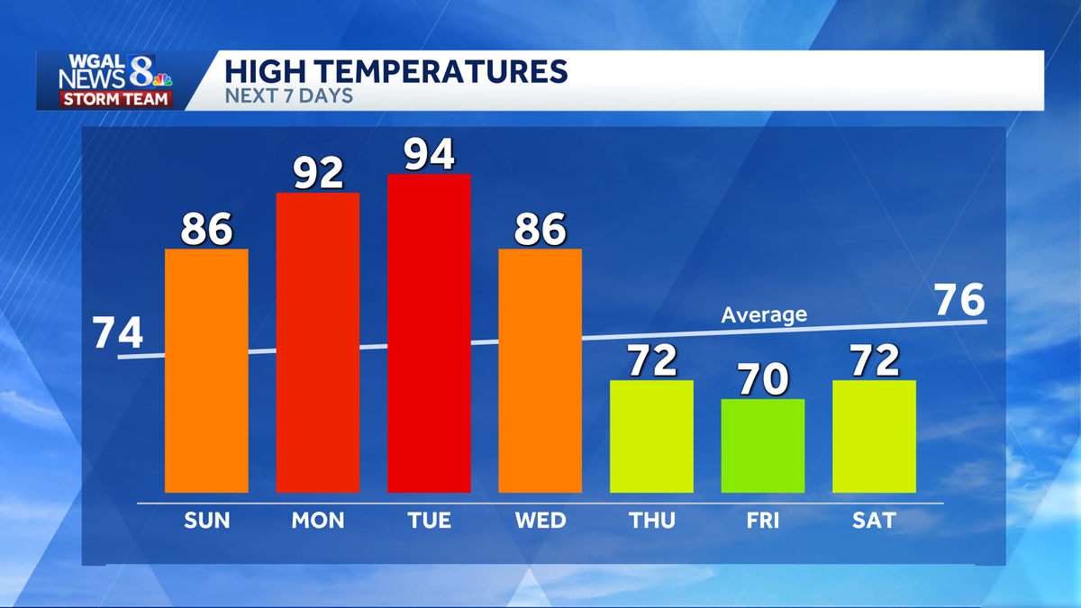
TEAM FORECAST WITH METEOROLOGIST MARYELLEN PANN. WELL, AFTER A WEEK OF TEMPERATURES BELOW AVERAGE, OUR AVERAGE HIGH THIS TIME OF YEAR IS AROUND 74 DEGREES. WE ARE GOING TO SEE A SIGNIFICANT SWING UPWARD AS WE HEAD INTO THE 80S THIS WEEKEND. MONDAY. TUESDAY. OUR FIRST 90 DEGREE DAYS OF THE YEAR COULD EVEN COME CLOSE TO RECORDS. AND OUR NEXT BEST CHANCE FOR WIDESPREAD SHOWERS AND STORMS WILL BE ON WEDNESDAY. SO YOUR STORM TEAM FORECAST FOR TODAY. MOSTLY SUNNY SKIES AROUND 9:00. TEMPERATURES AT 62 DEGREES. WE’RE HEADED FOR A HIGH OF 82. ONCE WE GET INTO THE EVENING HOURS, WE’LL SEE A LITTLE MORE CLOUD COVER MOVING IN, AND THERE COULD BE A FEW SHOWERS AROUND THE AREA OVERNIGHT TONIGHT, DECREASING CLOUDS, SHOWER THREAT AND TEMPERATURES THOUGH WILL BE WARM IN THE LOW 60S. AND TOMORROW WE’RE LOOKING AT PARTLY SUNNY SKIES AND ISOLATED SHOWER OR THUNDERSTORM IN THE AFTERNOON. THE EARLY EVENING WILL BE POSSIBLE. IT MAY BE A LITTLE STICKY. TOMORROW. TEMPERATURES WILL BE WARM IN THE MID 80S. HERE’S A LOOK AT YOUR TEN DAY FORECAST. WE SEE THOSE NUMBERS JUMPING INTO THE LOW 90S, FEELING MORE LIKE SUMMER WITH THE HEAT AND HUMIDITY. MONDAY AND TUESDAY. AND AGAIN, A POTENT SYSTEM COMES THROUGH ON WEDNESDAY. WE’VE HIGHLIGHTED HIGHLIGHTED THE DAY AS AN IMPACT DAY BECAUSE OF THE THREAT FOR WIDESPREAD SHOWERS AND STORMS. WE’RE STILL IN THE WARM IN THE MID TO UPPER 80S, BUT THEN WE COOL BACK DOWN BELOW, BELOW AVERAGE IN THE 60S AND 70S FOR THE REST OF THE WEEK. AND IT DOES LOOK LIKE THE MEMORIAL DAY HOLIDAY WEEKEND STARTS OUT DRY, BUT WE COULD SEE SOME SHOWERS SUNDAY AND MONDAY. SO LET’S TALK ABOUT THE RECORDS. THE HIGH TOMORROW IS SAFE. THE RECORD IS 91. WE’RE FORECASTING 86. BUT MONDAY THE RECORD IS 94. OUR FORECAST IS 92. THE RECORD ON TUESDAY IS 95. BOTH RECORDS SET IN 1962. AND WE HAVE A GOOD CHANCE OF HITTING THAT RECORD WITH A FORECAST OF 94. AND THE RECORD 95 WILL COME. DEFINITELY COME CLOSE WEDNESDAY. THE RECORD IS 94, SO I THINK THAT RECORD IS SAFE WITH THE FORECAST OF 86 ON AVERAGE. WE SEE OUR FIRST 90 DEGREE DAY AROUND JUNE 1ST. THE EARLIEST CAME ON APRIL 17TH IN 2002 AND 1896. THE LATEST WAS JULY 30TH, WAY BACK IN 1917. SO YESTERDAY WE HIT 70 DEGREES. YESTERDAY’S AVERAGE WAS 73, SO STILL A LITTLE BELOW AVERAGE. YOU CAN SEE THE LOW WAS 50. NO PRECIPITATION. SO WE’RE GOING TO SEE THOSE TEMPERATURES WELL ABOVE AVERAGE NOT ONLY TODAY BUT ESPECIALLY TOMORROW MONDAY AND TUESDAY. TEMPERATURES ARE IN THE UPPER 40S TO LOW 50S AT THIS HOUR. SO IT’S FEELING QUITE NICE. HIGH PRESSURE AND THE FLOW AROUND THAT HIGH WILL PUMP IN THAT WARM AIR. OUR NEXT SYSTEM IS STILL WELL OFF TO THE WEST. A LITTLE DISTURBANCE COMING THROUGH THIS EVENING COULD TRIGGER A FEW SHOWERS ACROSS THE AREA. I DON’T ANTICIPATE MUCH AT ALL WITH THIS SYSTEM THAT COMES THROUGH. YOU CAN SEE SOME SHOWERS. NOT EVERYBODY WILL SEE THEM, BUT JUST KEEP AN EYE TO THE SKY. THEN THEY’RE OUT OF HERE NOW. TOMORROW, WITH THE HEAT BUILDING AND A LITTLE MORE HUMIDITY IN THE AIR, IT’S NOT GOING TO BE OVERALL OPPRESSIVE OR ANYTHING LIKE THAT. YOU’LL JUST FEEL A LITTLE STICKINESS. BUT THERE MAY BE AN ISOLATED SHOWER OR THUNDERSTORM IN THE AFTERNOON OR EARLY EVENING, BUT PLENTY OF DRY HOURS FOR TOMORROW. ON MONDAY. THE HEAT AND HUMIDITY REALLY CRANKING UP. WE COULD ALSO SEE SOME ISOLATED STORMS IN THE AFTERNOON, NOT ONLY MONDAY, BUT AGAIN ON TUESDAY, SO YOU’LL JUST WANT TO KEEP AN EYE ON THE SKY AT THAT TIME OF YEAR. WE GET THE HEAT AND HUMIDITY BUILDING. WE COULD SEE SOME OF THOSE STORMS, BUT AGAIN, THE BEST CHANCE FOR WIDESPREAD SHOWERS AND STORMS WILL BE ON WEDNESDAY. TEMPERATURES STILL QUITE WARM AND ABOVE AVERAGE, BUT THAT FRONT WILL LEAD TO SOME COOLER TEMPERATURES AS WE HEAD INTO THE REST OF THE WEEK. THURSDAY AND FRIDAY, RIGHT AROUND 70 DEGREES. COULD HAVE A EARLY MORNING SHOWERS. THURSDAY. A FEW SHOWERS LATE ON FRIDAY, BUT BOTH DAY
Summerlike heat and near-record highs early next week in south-central Pennsylvania
Highs will soar to the 90s Monday and Tuesday, and it will feel even warmer, as humidity levels climb

Updated: 6:41 PM EDT May 16, 2026
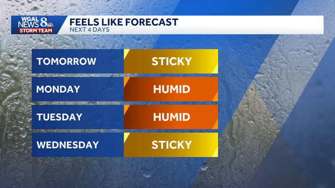
A significant warm-up is headed for south-central Pennsylvania, with temperatures surging from the 80s this weekend to the low-to-mid-90s early next week.Monday will bring the region’s first 90-degree day of the year, with even hotter weather expected on Tuesday. The average high for both days is 74 degrees. In addition, humidity levels will be on the increase, so it will feel like the mid-90s Monday, and mid-to-upper 90s Tuesday. There’s also a chance for isolated thunderstorms both days. From late spring temperatures to summer heatAfter a warm weekend, highs will soar into the 90s early next week.Monday: 92 degreesTuesday: 94 degreesWednesday: 86 degrees The warmest day so far this year was 88 degrees on April 16.Records will be challenged In Harrisburg, the forecast high is 92 on Monday, compared with the record of 94 set in 1962. Tuesday’s forecast high is 94, just below the record of 95, also set in 1962. Morning lows are also in jeopardy:Monday morning | Forecast low: 64, Record warm low: 67 set in 2017. Tuesday | Forecast low: 68, Record warm low: 67 set in 2017.Wednesday | Forecast low: 70, Record warm low: 67 set in 1931. Notable early-season heatThe average first 90-degree day in the region is June 1, so this stretch is arriving a bit ahead of schedule.Still, it is far from the earliest on record. The earliest first 90-degree day on record was April 17, while the latest did not occur until July 30, 1917. The WGAL News 8 Storm Team will continue to track the forecast and provide updates.Did you capture a moment that you would like to share with News 8? Send us your photos or videos at https://www.wgal.com/upload.
A significant warm-up is headed for south-central Pennsylvania, with temperatures surging from the 80s this weekend to the low-to-mid-90s early next week.
Monday will bring the region’s first 90-degree day of the year, with even hotter weather expected on Tuesday. The average high for both days is 74 degrees.
Hearst Owned
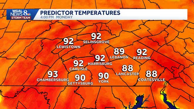
Monday’s highs
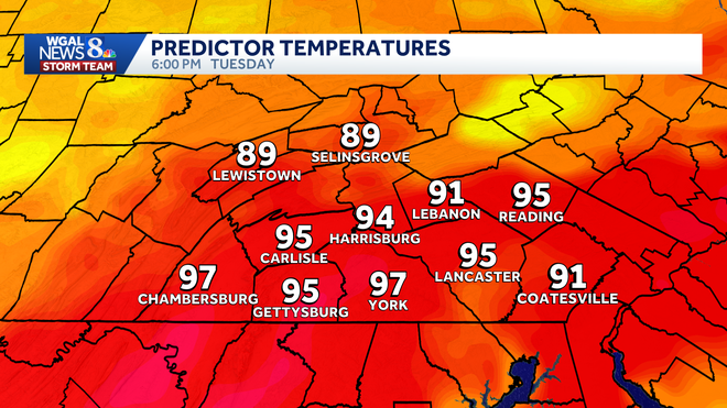
In addition, humidity levels will be on the increase, so it will feel like the mid-90s Monday, and mid-to-upper 90s Tuesday. There’s also a chance for isolated thunderstorms both days.
This content is imported from Woobox.
You may be able to find the same content in another format, or you may be able to find more information, at their web site.
From late spring temperatures to summer heat
After a warm weekend, highs will soar into the 90s early next week.
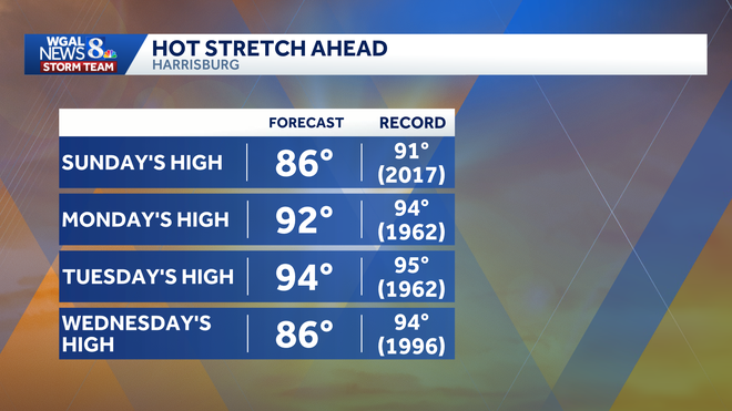
Monday: 92 degreesTuesday: 94 degreesWednesday: 86 degrees
The warmest day so far this year was 88 degrees on April 16.
Records will be challenged
In Harrisburg, the forecast high is 92 on Monday, compared with the record of 94 set in 1962. Tuesday’s forecast high is 94, just below the record of 95, also set in 1962.
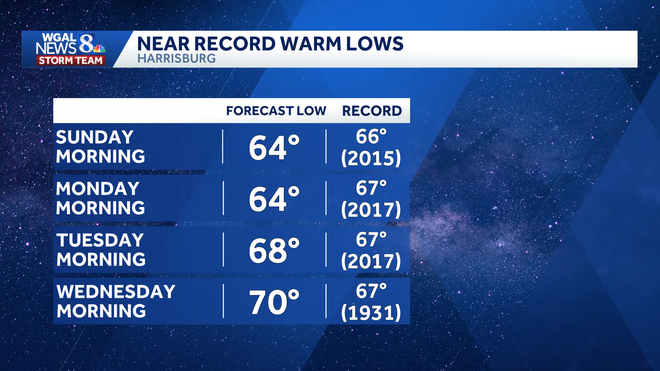
Morning lows are also in jeopardy:
Monday morning | Forecast low: 64, Record warm low: 67 set in 2017. Tuesday | Forecast low: 68, Record warm low: 67 set in 2017.Wednesday | Forecast low: 70, Record warm low: 67 set in 1931.
Notable early-season heat
The average first 90-degree day in the region is June 1, so this stretch is arriving a bit ahead of schedule.
Still, it is far from the earliest on record. The earliest first 90-degree day on record was April 17, while the latest did not occur until July 30, 1917.
The WGAL News 8 Storm Team will continue to track the forecast and provide updates.
Did you capture a moment that you would like to share with News 8? Send us your photos or videos at https://www.wgal.com/upload.