
CODE ORANGE: Air quality alert issued for parts of south-central Pennsylvania
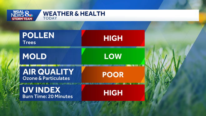
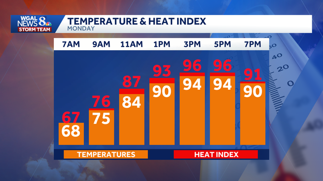
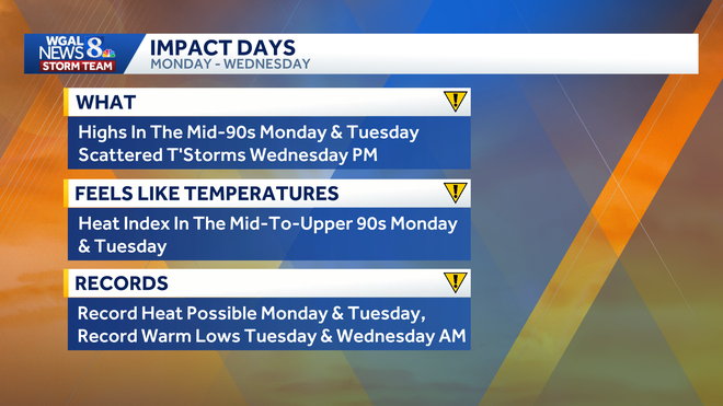
ALL DAY FORECAST WITH THE WGAL NEWS EIGHT STORM TEAM. GOOD MORNING. IT IS 645 IMPACTS FOR HEAT TODAY AND TOMORROW. WE ARE GOING TO SIZZLE HERE WITH HIGH TEMPERATURES WELL INTO THE 90S CHALLENGING RECORD HIGHS. SO HERE’S THE TEMPERATURE TODAY. IN THE ORANGE BOXES WE GET 94 WHICH IS THE RECORD. AND THEN THE HEAT INDEX ON TOP OF IT THERE IN THE RED IT’S GOING TO FEEL LIKE 96 DEGREES WHEN YOU FACTOR IN THAT HUMIDITY THIS AFTERNOON. IN ADDITION, WE HAVE A FEW THUNDERSTORMS POSSIBLE TOWARD EVENING, I’D SAY ISOLATED AT BEST. IF YOU DO SEE A THUNDERSTORM, THERE’S A CHANCE THAT IT COULD PRODUCE ISOLATED DAMAGING WIND GUSTS AND BRIEF HEAVY RAIN. THE HIGHEST CHANCE I’D FAVOR WEST OF THE RIVER AROUND DINNERTIME UNTIL ABOUT SUNSET. SO YOU CAN SEE THAT HERE ON THE PREDICTOR. NOT MUCH HAPPENING ALL DAY BESIDES THAT SWELTERING HEAT AND HIGH HUMIDITY. BUT HERE’S THOSE ISOLATED THUNDERSTORMS STARTING AT 5 P.M. BY 7:00, THEY ARE WEST OF THE RIVER, AND THEN THEY FIZZLE OUT AFTER THE SUN GOES DOWN EAST OF THE SUSQUEHANNA RIVER. NEWS EIGHT STORM TEAM FORECAST TODAY. THE BIG STORY. IT’S THE HEAT. SO WE’RE GOING WITH HOT AND HUMID CONDITIONS FOR THIS TIME OF THE YEAR. WITH THAT TEMPERATURE UP NEAR 94 DEGREES THIS EVENING. STRAY THUNDERSTORMS STILL WARM AND STICKY, ESPECIALLY AT 8:00, WILL BE WELL INTO THE UPPER 80S. TONIGHT WE DROP DOWN TO ABOUT 68 DEGREES, MOSTLY CLEAR, WARM AND HUMID. THERE COULD BE A TOUCH OF PATCHY FOG. AND TOMORROW WE DO IT AGAIN. SAME EXACT FORECAST. WE GET THE SIZZLING SUNSHINE NEAR RECORD HEAT. THE RECORD STANDS AT 95 AND A STRAY SHOWER OR THUNDERSTORM TOWARD EVENING. HERE’S YOUR CURRENTS AT 64 DEGREES IN HARRISBURG, 59. YORK 60 IN LANCASTER. AND BOY, THIS IS THE COOLEST TIME OF THE DAY. SO IF YOU WANT TO GET OUT FOR A WALK OR RUN WATER THE GARDEN, NOW IS THE TIME TO DO IT. IT’S GOING TO FEEL HUMID THIS AFTERNOON, ESPECIALLY FOR MAY. WE HAVE DEW POINTS IN THE LOW TO MID 60S. SAME DEAL FOR TOMORROW, BUT ON WEDNESDAY A COLD FRONT COMES THROUGH AND THAT REALLY CHANGES THE GAME. AT THE END OF THE WEEK IT WILL FEEL MUCH MORE COMFORTABLE BY THURSDAY FRIDAY INTO THE HOLIDAY WEEKEND. BUT IT’S ALSO GOING TO BE CONSIDERABLY COOLER. WEATHER HEALTH UPDATE TREE POLLEN LEVELS ARE HIGH TODAY. OUR AIR QUALITY IS MODERATE FOR OZONE AND PARTICULATES. LOOK AT THE UV INDEX. IT’S A HIGH ONE WITH A BURN TIME OF JUST 20 MINUTES. YOU CAN THANK HIGH PRESSURE FOR ALL THIS HEAT AND HUMIDITY. IT’S SITTING RIGHT OFFSHORE NOW, CRANKING UP THOSE STRONG SOUTHERLY WINDS. SO BOTH TODAY AND TOMORROW, THE PEAK OF THE HEAT THIS WEEK IN OUR TEN DAY FORECAST, THERE’S THE BIG BLUE H STAYING RIGHT TO OUR SOUTH, GIVING US THAT SOUTHERLY WIND AND THE ISOLATED CHANCE OF A SHOWER OR THUNDERSTORM TOWARD EVENING FOR TOMORROW. SAME FORECAST REPEATS. SUN IN THE MORNING. A FEW SHOWERS BUBBLE UP IN THE AFTERNOON AND THEN THINGS QUIET DOWN LATE IN THE EVENING. HERE WE GO INTO WEDNESDAY WITH A COLD FRONT COMING IN WEDNESDAY MORNING WE GET SUNSHINE WEDNESDAY AFTERNOON. CLOUDS INCREASE AND THEN WE GET SOME OF THOSE SCATTERED SHOWERS AND THUNDERSTORMS WEDNESDAY AFTERNOON. WEDNESDAY EVENING, ISOLATED STORMS MAY PRODUCE HEAVY RAIN AND DAMAGING WIND GUSTS ON WEDNESDAY. SO ALL OF THOSE DAYS ARE IMPACT DAYS FOR THE HEAT AND THE STORM CHANCE AFTER THAT. THURSDAY’S HIGH IS 68. FRIDAY WE’RE AT 64. SATURDAY HOLDS THE BEST CHANCE FOR RAIN OVER THE HOLIDAY WEEKEND. THEN WE’LL JUST SEE SOME INTERMITTENT SHOWERS ON SUNDAY, MEMORIAL DAY AND TUESDAY. SO IT CERTAINLY WON’T BE RAINING ALL THE TIME. TEMPERATURES EVENTUALLY GET BACK UP TO 72 ON MEMORIAL DAY, AND TH
CODE ORANGE: Air quality alert issued for parts of south-central Pennsylvania

Updated: 9:30 AM EDT May 18, 2026
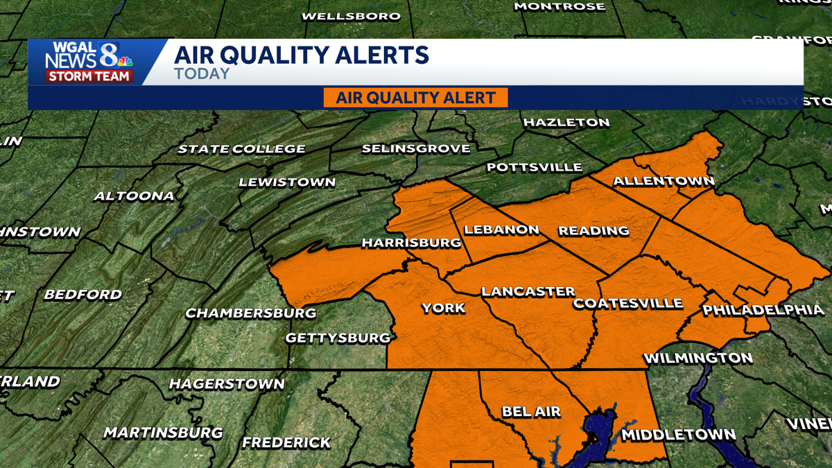
A Code Orange air quality alert was issued for parts of the Susquehanna Valley on Monday, according to the Pennsylvania Department of Environmental Protection. The alert is in effect for the following counties until midnight. DauphinCumberlandLancasterLebanonYorkOfficials warn that ground-level ozone concentrations are expected to rise to unhealthy levels for sensitive groups, including: ChildrenOlder adultsPeople with asthmaPeople with heart diseasePeople with other lung diseasesThe combination of hot temperatures and stagnant air can help ozone build near the ground, leading to reduced air quality, according to the DEP. Take precautionsPeople in sensitive groups are encouraged to limit prolonged or strenuous outdoor activity, especially during the hottest part of the day.Officials recommend:Avoiding strenuous outdoor exerciseTaking frequent breaks if outsideMoving activities indoors when possibleMonitoring for breathing problems or other symptomsMonday’s forecastMonday will bring some of the hottest weather of the year so far to the Susquehanna Valley, with a high near 94 degrees and heat index values in the mid-to-upper 90s. Humid conditions and a chance for isolated late-day thunderstorms, especially west of the Susquehanna River, have prompted the WGAL News 8 Storm Team to declare an Impact Day. Did you capture a moment that you would like to share with News 8? Send us your photos or videos at https://www.wgal.com/upload.
A Code Orange air quality alert was issued for parts of the Susquehanna Valley on Monday, according to the Pennsylvania Department of Environmental Protection.
The alert is in effect for the following counties until midnight.
DauphinCumberlandLancasterLebanonYork
Officials warn that ground-level ozone concentrations are expected to rise to unhealthy levels for sensitive groups, including:
ChildrenOlder adultsPeople with asthmaPeople with heart diseasePeople with other lung diseases
The combination of hot temperatures and stagnant air can help ozone build near the ground, leading to reduced air quality, according to the DEP.
Take precautions
People in sensitive groups are encouraged to limit prolonged or strenuous outdoor activity, especially during the hottest part of the day.
Officials recommend:
Avoiding strenuous outdoor exerciseTaking frequent breaks if outsideMoving activities indoors when possibleMonitoring for breathing problems or other symptoms
Monday’s forecast
Monday will bring some of the hottest weather of the year so far to the Susquehanna Valley, with a high near 94 degrees and heat index values in the mid-to-upper 90s. Humid conditions and a chance for isolated late-day thunderstorms, especially west of the Susquehanna River, have prompted the WGAL News 8 Storm Team to declare an Impact Day.
Did you capture a moment that you would like to share with News 8? Send us your photos or videos at https://www.wgal.com/upload.