
Heavy rain and strong winds to impact Susquehanna Valley Thursday, Friday
RAIN IS BECOMING WIDESPREAD OUT THERE ACROSS THE SUSQUEHANNA VALLEY. I EXPECT THE RAIN TO INTENSIFY THROUGH THE NIGHT TONIGHT. IT’S GOING TO BE COMING DOWN QUITE HEAVILY FIRST THING TOMORROW MORNING. THEN THE RAIN WILL TAPER BACK TO SCATTERED SHOWERS, BUT WE COULD SEE A FEW STRONG THUNDERSTORMS IN THE MIX ALONG WITH SOME GUSTY WINDS TOMORROW AFTERNOON. UP TO NEAR 40MPH. SO THAT’S WHY TOMORROW IS AN IMPACT DAY. THE WINDS WILL REMAIN STRONG THROUGH HALLOWEEN ON FRIDAY, SO THAT COULD PUT A HINDER ON SOME HALLOWEEN PLANS OUT THERE. SO JUST BE ADVISED WE COULD SEE SOME GUSTY WINDS UNTIL ABOUT AN HOUR OR TWO AFTER SUNSET. SO WE’LL START TO SEE THE WINDS DROP DURING TRICK OR TREATING FOR OUR FRIDAY. FINALLY, AS WE GET INTO THE WEEKEND, THE WEATHER WILL CALM DOWN AND TEMPERATURES WILL BE A LITTLE BIT COOLER THAN AVERAGE. BUT OUTSIDE RIGHT NOW YOU CAN SEE THE RAIN IS ON THE CAMERA LENS AS WE LOOK LIVE OVER LANCASTER, TEMPERATURES ARE STILL RELATIVELY MILD. WE’RE AT 51 DEGREES, BUT NOTICE THE WINDS NOW UP TO TEN MILES PER HOUR. WITH THAT STEADY RAIN COMING DOWN, YOU CAN SEE LIVE LOCAL RADAR ALL LIT UP AS THE RAIN IS BECOMING WIDESPREAD ACROSS THE REGION. WE DO HAVE SOME EMBEDDED AREAS OF SOME MODERATE TO HEAVY RAIN MOVING THROUGH NORTHERN PORTIONS OF FRANKLIN COUNTY AND OUT INTO WESTERN PORTIONS OF CUMBERLAND, PERRY AND JUNIATA COUNTIES. SO WE’LL CONTINUE TO SEE STEADY RAIN THROUGH THE NIGHT TONIGHT, BUT I DO EXPECT IT TO INTENSIFY AS THE CENTER OF THE STORM THAT’S NOW SPINNING SOMEWHERE NEAR NASHVILLE WILL WORK ITS WAY UP AND INTO THE HEART OF THE SUSQUEHANNA VALLEY THROUGH THE DAY TOMORROW. SO WIDESPREAD RAIN THROUGH THE NIGHT THAT WILL INTENSIFY AS WE GET CLOSER TO DAWN, WITH TEMPERATURES BOTTOMING OUT IN THE UPPER 40S. BE PREPARED FOR A RAW, WINDY, WET START TO TOMORROW AS TEMPERATURES WILL BE IN THE 50S. WITH THAT STEADY, HEAVY RAIN COMING DOWN, AND THEN AFTER LUNCHTIME, THE RAIN WILL TAPER BACK TO SOME SCATTERED SHOWERS. BUT WE COULD SEE THOSE THUNDERSTORMS OUT THERE AND THAT REALLY IS GOING TO BE A BIG THING WITH IN TERMS OF THE TEMPERATURES, THE WARMER WE SEE THOSE TEMPERATURES, THE HIGHER THE CHANCES FOR SOME STRONGER THUNDERSTORMS. BUT FOR AREAS THAT STAY IN THE 50S, LOWER CHANCES FOR THOSE STRONGER THUNDERSTORMS. I DO BELIEVE AREA WIDE WE’RE GETTING THAT RAINFALL AND IT IS GOING TO BE A GOOD SOAKING THANKS TO THE FACT THAT WE HAVE BEEN QUITE DRY OVER THE PAST COUPLE OF WEEKS, OUR GROUND IS GOING TO BE ABLE TO HANDLE THIS, BUT WE’RE LOOKING AT ONE TO ABOUT 2.5IN OF RAIN, AND THERE COULD BE SOME ISOLATED HIGHER TOTALS. OVERALL THREAT FOR SEVERE WEATHER IS LOW, BUT IT IS OUT THERE ROUGHLY BETWEEN 12 AND 5:00. DAMAGING WINDS IS WHAT WE’RE GOING TO HAVE TO WATCH OUT FOR. COULD SEE SOME PONDING WATER ON SOME ROADWAYS, AND IF THE ENVIRONMENT IS JUST RIGHT, A BRIEF SPIN UP TORNADO IS POSSIBLE. BUT CHANCES OF THAT HAPPENING ARE INCREDIBLY LOW. MADE IT TO 58 FOR OUR HIGH TODAY. START THE DAY OFF AT 38 DEGREES, BUT IT’S STILL 54 WITH THE RAIN COMING DOWN. NOW FOR YOU FOLKS IN HARRISBURG, 53 CURRENTLY IN HERSHEY, 51 IN LANCASTER AND 49 AT THIS HOUR IN QUARRYVILLE YOU CAN SEE A LITTLE BIT OF MILDER AIR ALONG THE EAST COAST. TEMPERATURES IN THE 60S TO NEAR 70 DEGREES IN FLORIDA. WE’RE GOING TO TAP INTO SOME OF THIS WARMER AIR THAT’S ON THE EAST SIDE OF THE STORM. AS THE STORM MOVES UP FROM THE SOUTHWEST. SO WATCH WHAT HAPPENS HERE ON THE PREDICTOR. WE’LL TAKE YOU HOUR BY HOUR. NOTICE THE RAINFALL PICKING UP IN INTENSITY, SHOWING YOU THOSE BRIGHTER YELLOWS, THOSE EMBEDDED ORANGES THAT WILL CONTINUE THROUGH THE MORNING COMMUTE. HERE WE ARE AT 8 A.M. THEN THE WARM FRONT WILL LIFT OVERHEAD SO THE STEADIER RAIN MOVES TO OUR NORTH. BUT DURING THE AFTERNOON AND WE GET IN ON THE WARM SIDE OF THE STORM, THAT’S WHERE WE COULD SEE THOSE SCATTERED SHOWERS AND THUNDERSTORMS. BUT BY 5:00, WE’LL START DRYING BACK OUT. BUT THEN WE’LL HAVE THE BACK AREA OF LOW PRESSURE SPINNING OFF TO OUR WEST. THAT WILL CONTINUE TO ALLOW FOR A BLUSTERY NIGHT TOMORROW NIGHT, BUT THE WINDS WILL PICK BACK UP AS WE GO THROUGH THE DAY ON FRIDAY. AS THE STORM INTENSIFIES OVER NEW ENGLAND. BUT I DO EXPECT WE ARE GOING TO BE DRY. IT’S JUST GOING TO BE PRETTY WINDY OUT THERE WITH THOSE WIND GUSTS IN EXCESS OF 30MPH, POSSIBLY UP TO 40MPH. BUT NOTICE ONCE WE GET PAST SUNSET FOR A LOT OF TRICK OR TREATERS OUT THERE, WE’LL START TO SEE THE WINDS IMPROVE. BUT IT IS STILL GOING TO BE BLUSTERY OUT THERE FOR HALLOWEEN EVENING. SO JUST BE ADVISED IF YOU’RE GOING OUT THERE FOR TRICK OR TREATING IS GOING TO BE DRY, BUT BUNDLE THE KIDS UP. WE ARE DRY FOR THE WEEKEND AHEAD WITH TEMPERATURES IN THE UPPER 50S FOR BOTH SATURDAY AND SUNDAY. MOST OF NEXT WEEK LOOKS DRY. IT’S ONCE WE HEAD INTO THURSDAY, COULD SEE SOME SPOTTY SHOWERS, AND THEN AGAIN LATE SATURDAY NIGHT IN
Heavy rain and strong winds to impact Susquehanna Valley Thursday, Friday

Updated: 11:26 PM EDT Oct 29, 2025
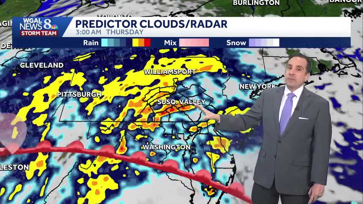
Heavy rain and high winds are in the forecast for South-Central Pennsylvania later this week. As low-pressure approaches from the Midwest, widespread rain will develop Wednesday night, and lows will be milder, in the upper 40s.Heavy rain is expected Thursday with blustery conditions. Friday, the winds persist and there is a chance of isolated showers. The WGAL News 8 Storm Team has designated Thursday and Friday as Impact Days, meaning the weather could disrupt your normal daily schedule or routine.Thursday: Morning rain and gusty windsImpact Day: Rain could be heavy during the morning commute, leading to ponding on roads and slippery conditions from wet leaves.Wind: Gusts up to 40 mph are expected.Rainfall totals: 1 to 2.5 inches. Due to the motion of the storm, we could see isolated higher totals.Afternoon and evening: Rain will taper off to scattered showers by the afternoon and become drier by evening. There is a low threat for some strong thunderstorms. Areas that see temperatures in the 60s will have a higher chance for these storms, while it’s less likely for areas seeing temperatures in the 50s. The best times for severe weather will be between 12 and 5 p.m. on Thursday. A brief spin up tornado is possible, but chances are very low. High temperature: Around 66°F in some areas. Friday: Windy with isolated showersImpact Day: Strong winds will persist as low pressure moves into New England.Wind: Sustained winds of 15-25 mph with gusts up to 40 mph, potentially causing isolated power outages. Trick-or-treat forecast: Dry but breezyConditions: Partly cloudy to mostly clear skies with dry, windy weather.Temperatures: Upper 40s to low 50s, so dress warmly.Stay cautious during the morning commute Thursday and prepare for gusty winds through Friday.
Heavy rain and high winds are in the forecast for South-Central Pennsylvania later this week.
As low-pressure approaches from the Midwest, widespread rain will develop Wednesday night, and lows will be milder, in the upper 40s.
Heavy rain is expected Thursday with blustery conditions. Friday, the winds persist and there is a chance of isolated showers.
The WGAL News 8 Storm Team has designated Thursday and Friday as Impact Days, meaning the weather could disrupt your normal daily schedule or routine.
Thursday: Morning rain and gusty windsImpact Day: Rain could be heavy during the morning commute, leading to ponding on roads and slippery conditions from wet leaves.Wind: Gusts up to 40 mph are expected.Rainfall totals: 1 to 2.5 inches. Due to the motion of the storm, we could see isolated higher totals.Afternoon and evening: Rain will taper off to scattered showers by the afternoon and become drier by evening. There is a low threat for some strong thunderstorms. Areas that see temperatures in the 60s will have a higher chance for these storms, while it’s less likely for areas seeing temperatures in the 50s. The best times for severe weather will be between 12 and 5 p.m. on Thursday. A brief spin up tornado is possible, but chances are very low. High temperature: Around 66°F in some areas.
Friday: Windy with isolated showers
Impact Day: Strong winds will persist as low pressure moves into New England.Wind: Sustained winds of 15-25 mph with gusts up to 40 mph, potentially causing isolated power outages. Trick-or-treat forecast: Dry but breezyConditions: Partly cloudy to mostly clear skies with dry, windy weather.Temperatures: Upper 40s to low 50s, so dress warmly.
Stay cautious during the morning commute Thursday and prepare for gusty winds through Friday.