
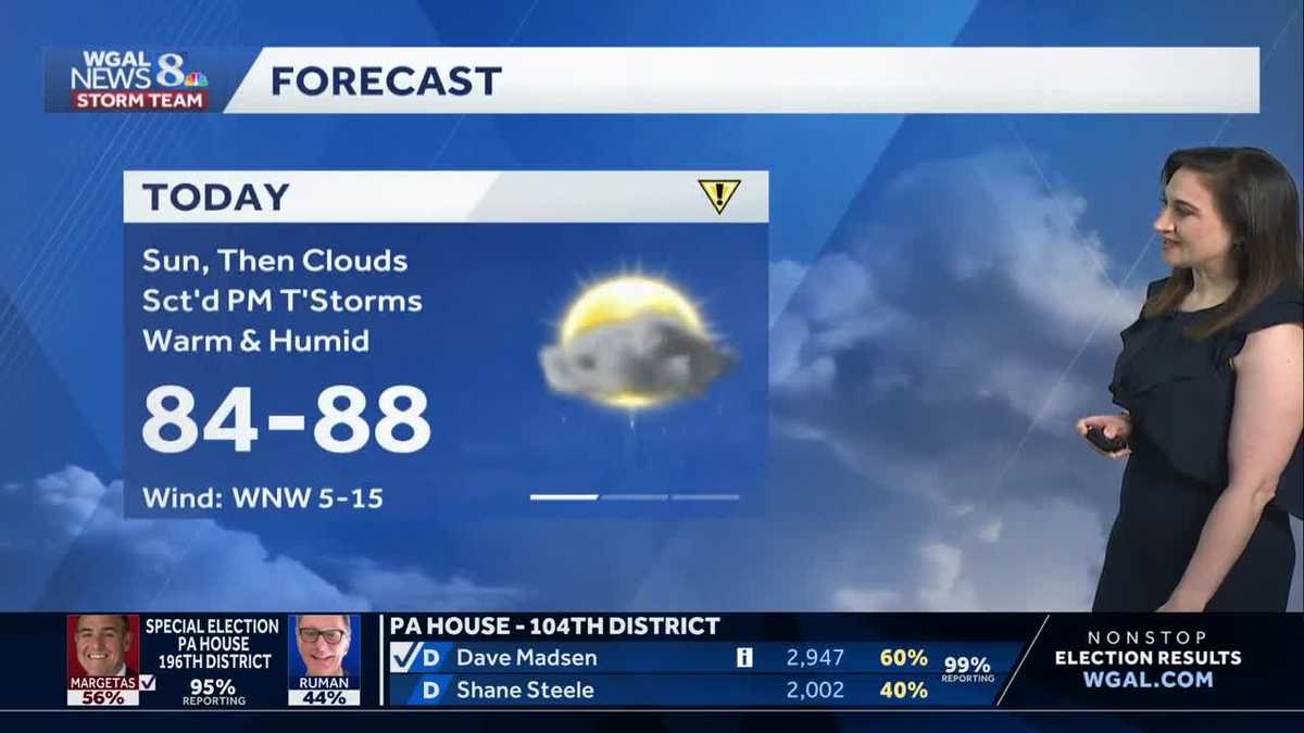
Sun, then scattered storms today; rain Thursday in south-central Pennsylvania
After two days in the 90s, highs will fall to the 80s today, then drop to the low 60s Thursday
DISCUSSING THESE OPTIONS DURING A MEETING TOMORROW. NOW, THE IMPACT DAY FORECAST FROM THE WGAL NEWS EIGHT STORM TEAM. GOOD MORNING. TODAY IS AN IMPACT DAY NOT FOR THE HEAT LIKE THE PAST FEW DAYS, BUT FOR THE CHANCE OF SOME STORMS. YOU CAN SEE WE ARE IN A LEVEL ONE OUT OF FIVE. A VERY LOW RISK FOR ANY SEVERE STORMS THIS AFTERNOON OR THIS EVENING. ISOLATED STORMS MAY PRODUCE DAMAGING WIND GUSTS, SOME SMALL HAIL AND OF COURSE ALL STORMS COULD PRODUCE HEAVY RAIN TODAY BECAUSE IT’S BEEN SO HUMID. SO WHAT WE’RE GOING TO BE WATCHING OUT FOR IS A WINDOW BETWEEN 2 P.M. AND 10 P.M. FOR ANY STRONGER STORMS. HERE’S A LOOK AT THE PREDICTOR. WE START OUT DRY AND CLEAR. WE GET A GOOD DOSE OF MORNING SUNSHINE AT LUNCHTIME. A FEW SHOWERS MIGHT TRY TO POP UP WEST, BUT NOTICE AFTER LUNCHTIME THAT’S WHEN WE START TO SEE A FEW SHOWERS AND THUNDERSTORMS AS WE HEAD TOWARD EVENING. THAT’S THE HIGHEST CHANCE. SO HERE WE ARE AT 6 P.M. YOU CAN SEE A BETTER CHANCE OF SCATTERED ACTIVITY BY THE TIME WE HIT 7:00 8:00. WE’RE STILL SEEING THAT, ESPECIALLY IN SOUTHEASTERN COUNTIES. AND THEN BY THE TIME WE GET TO TEN, 11:00, MOST OF THE ACTION IS OVER. THE SEVERE THREAT HAS ENDED. NEWS EIGHT STORM TEAM FORECAST TODAY. ON THIS IMPACT DAY, WE GO WITH HIGHS IN THE 80S. A LITTLE BIT OF A BREAK. STILL ABOVE AVERAGE. STILL HUMID OUT THERE BUT DRY TO START. THEN THE SHOWER. CHANCES OF THUNDERSTORM CHANCES ARE LATER TODAY. TONIGHT CLOUDY SKIES. LIGHT RAIN DEVELOPING AS A COLD FRONT STALLS NEARBY. IT’S NOT GOING TO BE AS MUGGY TONIGHT. CHECK OUT THE TEMPERATURES 54 TO 58 DEGREES. THAT’S A NICE CHANGE. TOMORROW WE HAVE MORNING RAIN DEVELOPING ACROSS THE ENTIRE AREA. IT’S GOING TO TAPER IN THE AFTERNOON, BUT IT COULD BE RAINING MOST OF THE DAY TOMORROW, ESPECIALLY IN SOUTHEASTERN COUNTIES. SO THIS FRONT HAS REALLY SLOWED LOW PRESSURE RIDING ALONG IT. AND THAT’S GOING TO BRING US A BETTER CHANCE OF LIGHT RAIN TOMORROW. NO SEVERE WEATHER TOMORROW. JUST A KIND OF A STEADY ALL DAY RAIN IN MANY SPOTS. TEMPERATURES WILL BE IN THE 60S. HERE’S THE ALMANAC. YESTERDAY’S HIGH MADE IT TO 93 THANKS TO THOSE STORMS IN THE AFTERNOON. WE DIDN’T GET CLOSE TO THE RECORD, WHICH WAS 95. SO AVERAGE IS 74 FOR THIS TIME OF THE YEAR. WE’RE KIND OF CLOSE TO THAT THIS MORNING IN SOME SPOTS AT 69 DEGREES IN HARRISBURG, AT 67 IN CHAMBERSBURG, WE HAVE 67 IN CARLISLE AND THEN 73 DEGREES IN CHAMBERSBURG. GETTING AHEAD OF MYSELF AS FAR AS OUR FEELS LIKE FORECAST GOES HUMID TODAY, TOMORROW IS GOING TO FEEL MORE COMFORTABLE. AND ON FRIDAY AND SATURDAY IT’S ALSO GOING TO FEEL COMFORTABLE, BUT IT’S GOING TO BE A BIT WET TO START THE HOLIDAY WEEKEND AND IT’S GOING TO BE COOL. WEATHER AND HEALTH UPDATE TODAY. TREE POLLEN LEVELS STILL HIGH. AIR QUALITY IS MODERATE FOR OZONE, AND OUR UV INDEX IS MODERATE TO START WITH A BURN TIME OF 35 MINUTES. AND THEN AS MORE CLOUDS COME IN IN THE AFTERNOON, THAT BURN TIME GETS LOWER AND LOWER. HERE’S THE STORM TEAM LIVE RADAR NETWORK WITH HIGH PRESSURE STATIONED OFFSHORE. THAT’S WHAT’S BEEN GIVING US THE HEAT AND THE HUMIDITY THIS WEEK. WE’LL TAKE A LOOK AT THAT COLD FRONT, DEFINITELY MARKED RIGHT ACROSS OHIO. AND THAT IS GOING TO COME INTO OUR NEIGHBORHOOD THIS AFTERNOON. SO HERE’S THE PREDICTOR AGAIN SHOWING AFTERNOON EVENING TIME FRAME FOR THE ARRIVAL OF THE SHOWERS, THUNDERSTORMS, POTENTIALLY STRONGER ONES THAT COULD PUT DOWN SOME HEAVY RAIN AND GUSTY WINDS. AFTER THAT, THINGS QUIET DOWN OVERNIGHT, BUT THIS COLD FRONT STILL SITS NEARBY. LOW PRESSURE FILLS IN THE RAIN TOMORROW MORNING INTO THE EARLY AFTERNOON. THERE COULD BE SOME MODERATE AREAS OF RAIN. AND FINALLY, BY LATE AFTERNOON, THE RAIN WILL BE PULLING OUT OF OUR SOUTHEASTERN COUNTIES, SO IT WILL LINGER LONGEST IN LANCASTER, YORK AND LEBANON COUNTIES, FINALLY EXITING TOWARD EVENING. NOW, FRIDAY LOOKS OKAY. I THINK WE’RE GOING TO SQUEEZE A LITTLE BIT OF SUNSHINE IN, PROVIDED WE GET HIGH PRESSURE THAT BUILDS ACROSS THE NORTHEAST HERE. THAT SHOULD HOLD OFF THE RETURN OF RAIN UNTIL WE GET TO FRIDAY NIGHT AND SATURDAY. SO WE’LL KEEP YOU POSTED ON THAT. HERE’S A LOOK AT THE TEN DAY FORECAST. SATURDAY’S HIGH 56 DEGREES. IT’S GOING TO BE THE COLDEST DAY OF THE HOLIDAY WEEKEND. IN ADDITION, IT COULD CHALLENGE THE RECORD COLDEST LOW, WHICH IS 54 DEGREES. WE WILL SEE RAINY CONDITIONS THROUGHOUT THE DAY SATURDAY IMPACTING YOUR OUTDOOR PLANS, BUT SUNDAY, SOME SHOWERS, SOME DRIZZLE TRENDING DRIER AND
Sun, then scattered storms today; rain Thursday in south-central Pennsylvania
After two days in the 90s, highs will fall to the 80s today, then drop to the low 60s Thursday

Updated: 6:11 AM EDT May 20, 2026
SUN, THEN STORMS TODAY:Look for morning sunshine, then increasing clouds this afternoon. Highs will reach the mid-80s, a slight cool down from the past 2 days. Ahead of a cold front, scattered showers and thunderstorms will develop this afternoon, and especially this evening. Isolated storms may produce damaging wind gusts and small hail. Heavy rain is also possible, along with frequent lightning. Tonight, the cold front will linger across Delmarva, and low pressure will develop along the front, leading to a period of light rain. It won’t be as muggy, and temperatures will be cooler, in the mid-50s. RAINY & COOLER THURSDAY:Light to moderate rain will continue Thursday morning through early afternoon. Rain will taper from northwest to southeast by late afternoon. Highs will be much cooler, near 62 degrees. DRIER FRIDAY:High pressure will move over the Northeast Friday, keeping most of the day dry. However, low pressure approaching from the southwest will allow rain to return late Friday night into Saturday morning. WET START TO THE HOLIDAY WEEKEND:Saturday holds the best chance of rain over the holiday weekend, as well as the coolest temperatures, thanks to flow from the east. Saturday’s highs will reach 56 degrees, just shy of the record coolest high for the day. (Record: 54 in 1982.) Scattered showers continue Sunday, but it looks drier by Memorial Day. Highs will hit the low 60s Sunday, then rise to 70 degrees Monday. WARMER NEXT WEEK:A few showers may be around Tuesday and Wednesday, but the trend is toward drier and warmer weather mid-to-late week. Expect highs back in the low-to-mid 80s Wednesday through Friday.
SUN, THEN STORMS TODAY:
Look for morning sunshine, then increasing clouds this afternoon. Highs will reach the mid-80s, a slight cool down from the past 2 days.
Ahead of a cold front, scattered showers and thunderstorms will develop this afternoon, and especially this evening. Isolated storms may produce damaging wind gusts and small hail. Heavy rain is also possible, along with frequent lightning.
Tonight, the cold front will linger across Delmarva, and low pressure will develop along the front, leading to a period of light rain. It won’t be as muggy, and temperatures will be cooler, in the mid-50s.
RAINY & COOLER THURSDAY:
Light to moderate rain will continue Thursday morning through early afternoon. Rain will taper from northwest to southeast by late afternoon. Highs will be much cooler, near 62 degrees.
DRIER FRIDAY:
High pressure will move over the Northeast Friday, keeping most of the day dry. However, low pressure approaching from the southwest will allow rain to return late Friday night into Saturday morning.
WET START TO THE HOLIDAY WEEKEND:
Saturday holds the best chance of rain over the holiday weekend, as well as the coolest temperatures, thanks to flow from the east. Saturday’s highs will reach 56 degrees, just shy of the record coolest high for the day. (Record: 54 in 1982.)
Scattered showers continue Sunday, but it looks drier by Memorial Day. Highs will hit the low 60s Sunday, then rise to 70 degrees Monday.
WARMER NEXT WEEK:
A few showers may be around Tuesday and Wednesday, but the trend is toward drier and warmer weather mid-to-late week. Expect highs back in the low-to-mid 80s Wednesday through Friday.