
Scattered rain and storms for western Pennsylvania ahead of wet Memorial Day weekend
More rain is on the way through Memorial Day weekend. The wettest time will be Friday night.
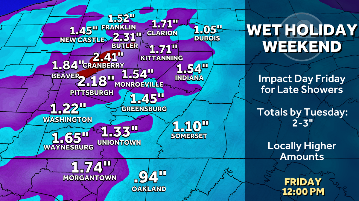
HOLIDAY WEEKEND WITHOUT MAJOR DELAYS. THAT’S SOMETHING WE’LL HAVE TO WATCH. WE DO HAVE AN IMPACT DAY ON FRIDAY, ESPECIALLY FOR THE SECOND HALF OF THE DAY. THERE COULD BE SOME HYDROPLANING AND SOME LOW VISIBILITY AS RAIN ROLLS IN. IMPACT DAY TODAY WE’VE GOT ANOTHER ROUND OF SOME SCATTERED SHOWERS AND STORMS, ESPECIALLY THROUGH THE AFTERNOON AND EVENING. A FEW ISOLATED SHOWERS, THOUGH, ARE ROLLING THROUGH THIS MORNING. VERY LIGHT IN NATURE. MOST OF US JUST HAVE SOME CLOUDS TO CONTEND WITH THIS MORNING AND SOME MILD TEMPERATURES. 66 WAKING UP IN PITTSBURGH, 63 RIGHT NOW IN WASHINGTON. THAT’S THE CASE ALSO IN UNIONTOWN, 64, KITTANNING, BUTLER AND CRANBERRY AND BEAVER WAKING UP AT 65. AS WE LOOK AT YOUR FOUR DAY FORECAST, WE’RE GOING TO SHOOT UP INTO LOW TO MID 70S TODAY. BREAKING DOWN THE NEXT 12 HOURS. REALLY THE MORNING LOOKS TO BE THE BEST OF THE DAY. GETTING A LITTLE BIT OF SUNSHINE IN SOME SPOTS AS WE GET INTO THE AFTERNOON AS EARLY AS 11 12:00. SOME ISOLATED THUNDERSTORMS WILL BE DEVELOPING, SOME POCKETS OF HEAVY RAIN. AND AS WE CONTINUE INTO THE EVENING, SOUTH AND EAST OF THE CITY OF PITTSBURGH COULD BE SOME OF THE HARDEST HIT AREAS. NOW GETTING INTO THE HOLIDAY WEEKEND, IT’S NOT THE BEST MEMORIAL DAY WEEKEND WE’RE LOOKING AT AS WE CONTINUE THROUGH MEMORIAL DAY INTO TUESDAY. COULD SEE AROUND A 2 TO 3IN OF RAIN WITH SOME OF THE HEAVIEST FRIDAY NIGHT AND INTO SATURDAY. SO WE’LL BE WATCHING THAT VERY CLOSELY HEADING INTO THE WEEKEND. SOME LIGHT SHOWERS ARE PUSHING THROUGH VERY LIGHT IN NATURE. MOVE THROUGH TOWNSHIP NOW RIGHT ALONG THE TURNPIKE THERE INTO NORTHERN PORTIONS OF ALLEGHENY COUNTY, AND WE’RE SEEING SOME LIGHT SHOWERS IN THE PORTIONS OF BUTLER RIGHT ALONG. 422 MOST OF THIS IS TRYING TO WORK ITS WAY IN, IS FIZZLING OUT. WHAT’S HOLDING TOGETHER SOME OF THOSE THUNDERSTORMS OUT NEAR CINCINNATI. SO WE’LL BE MONITORING THAT AS WE CONTINUE THROUGH THE MORNING, AS THAT WILL ROLL INTO OUR DIRECTION. THERE IS A MARGINAL RISK FOR STRONG TO SEVERE THUNDERSTORM TO DEVELOP, MEANING SOME DAMAGING WIND GUSTS. AS WE LOOK SOUTH OF INTERSTATE 70 AND EAST. AND HERE’S WHY. YOU CAN SEE IT HERE ON OUR FUTURECAST. THAT’S EXACTLY WHAT THEY’RE PICKING UP. WE HAVE A FEW SPOTTY SHOWERS, ISOLATED STORMS COMING IN BEFORE 11:00, BUT AROUND LUNCHTIME WE’LL START TO SEE SOME MORE WIDESPREAD RAIN TRYING TO DEVELOP. THIS IS 4:00. YOU CAN SEE IT’S JUST RIGHT ON OUR DOORSTEP COMING INTO GREENE AND FAYETTE COUNTY. IT LOOKS TO BE JUST MAINLY SOME RAIN SHOWERS NORTH, BUT THAT WE’RE SHOWING YOU THAT DARKER GREEN. THAT’S WHERE WE COULD HAVE A STRONG THUNDERSTORM TRYING TO DEVELOP. WESTMORELAND. PORTIONS OF FAYETTE, SOMERSET, DOWN INTO GREENE, CLIPPING SOUTHERN PARTS OF ALLEGHENY COUNTY INTO THE ELIZABETH AREA. SO AGAIN, THAT WILL BE ROLLING THROUGH STILL LOOKS LIKE ON THE BACKSIDE OF THIS FRONT AS IT’S CONTINUING TO MOVE EASTWARD. HAVE SOME RAIN SHOWERS EARLY TOMORROW MORNING, SOUTH AND EAST AGAIN GETTING HIT HARD WITH SOME MORE RAINFALL BEFORE THAT STARTS TO ROLL ON OUT. AND WE ARE EXPECTING TO DRY OUT AND SLOWLY WATCH THESE CLOUDS DECREASE FROM NORTH TO SOUTH. SO WE SHOULD FINISH OUT THE DAY WITH SOME SUNSHINE AS WE LOOK AT YOUR FOUR DAY PLUS FOUR MORE FORECAST. I HOPE YOU ENJOYED THE 80S AND EVEN INTO THE 70S. WE’RE DIPPING DOWN INTO THE MID TO UPPER 60S FOR THURSDA
Scattered rain and storms for western Pennsylvania ahead of wet Memorial Day weekend
More rain is on the way through Memorial Day weekend. The wettest time will be Friday night.

Updated: 7:40 AM EDT May 20, 2026
Wednesday is an Impact Day for spotty showers and storm chances. Areas south and east of Pittsburgh are at a higher risk of catching a stronger thunderstorm. A soggy pattern sets up for Memorial Day weekend. Friday is another Impact Day.Impact Day: Spotty showers and stormsToday is an Impact Day for off and on scattered rain along with a few late-day storms. A few showers will be around for your morning commute. The soggiest time period is likely the late morning through the afternoon. Isolated thunderstorm will be possible, especially in the Laurel Highlands. Severe weather is unlikely. Rain should end as we head into Thursday morning as the cold front clears. A cold front will help to usher back in more seasonal air for the weekend.Soggy stretch through Memorial DayRain looks to return late Friday and Saturday. Friday and Saturday will be the wettest period of the weekend with perhaps a couple of inches of rain. Friday is an Impact Day due to the heavy rain in the second half of the day. We may dry out a bit Sunday before more rain is possible on Memorial Day. Temperatures will trend more seasonal with highs in the mid 60s to 70s starting tomorrow.Summer feeling gradually returnsHigh temperatures will register closer to 80 degrees between the rain chances Sunday and Memorial Day. Conditions will remain mild and dry after the holiday.TODAY – Impact Day: Scattered rain and a few storms, especially south and east. High: 75°.TONIGHT: Rain lingers. Low: 50°.THURSDAY: Morning rain, not as warm afternoon. High: 67°, low: 53°.FRIDAY – Impact Day: Late-day rain will be heavy at times. High: 65°, low: 55°.SATURDAY: Rain showers. High: 72°, low: 60°.
Wednesday is an Impact Day for spotty showers and storm chances. Areas south and east of Pittsburgh are at a higher risk of catching a stronger thunderstorm. A soggy pattern sets up for Memorial Day weekend. Friday is another Impact Day.
Impact Day: Spotty showers and storms
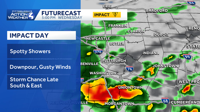
Today is an Impact Day for off and on scattered rain along with a few late-day storms. A few showers will be around for your morning commute. The soggiest time period is likely the late morning through the afternoon.
Hearst OwnedHearst
Today’s Impact Day will feature more rain and storm chance during the afternoon and evening.
Isolated thunderstorm will be possible, especially in the Laurel Highlands. Severe weather is unlikely. Rain should end as we head into Thursday morning as the cold front clears. A cold front will help to usher back in more seasonal air for the weekend.
Soggy stretch through Memorial Day
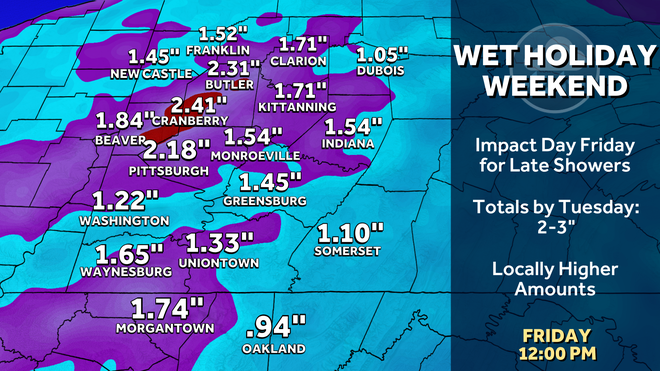
Rain looks to return late Friday and Saturday. Friday and Saturday will be the wettest period of the weekend with perhaps a couple of inches of rain. Friday is an Impact Day due to the heavy rain in the second half of the day.
Hearst OwnedHearst
A wet holiday weekend is on tap. The wettest period will be late Friday through Saturday.
We may dry out a bit Sunday before more rain is possible on Memorial Day. Temperatures will trend more seasonal with highs in the mid 60s to 70s starting tomorrow.
Summer feeling gradually returns
High temperatures will register closer to 80 degrees between the rain chances Sunday and Memorial Day. Conditions will remain mild and dry after the holiday.
Hearst OwnedHearst
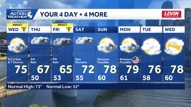
If you’re looking for a good time to grill out this weekend, consider some point on Sunday or Monday.
TODAY – Impact Day: Scattered rain and a few storms, especially south and east. High: 75°.
TONIGHT: Rain lingers. Low: 50°.
THURSDAY: Morning rain, not as warm afternoon. High: 67°, low: 53°.
FRIDAY – Impact Day: Late-day rain will be heavy at times. High: 65°, low: 55°.
SATURDAY: Rain showers. High: 72°, low: 60°.