
Drying out for Memorial Day in Western PA
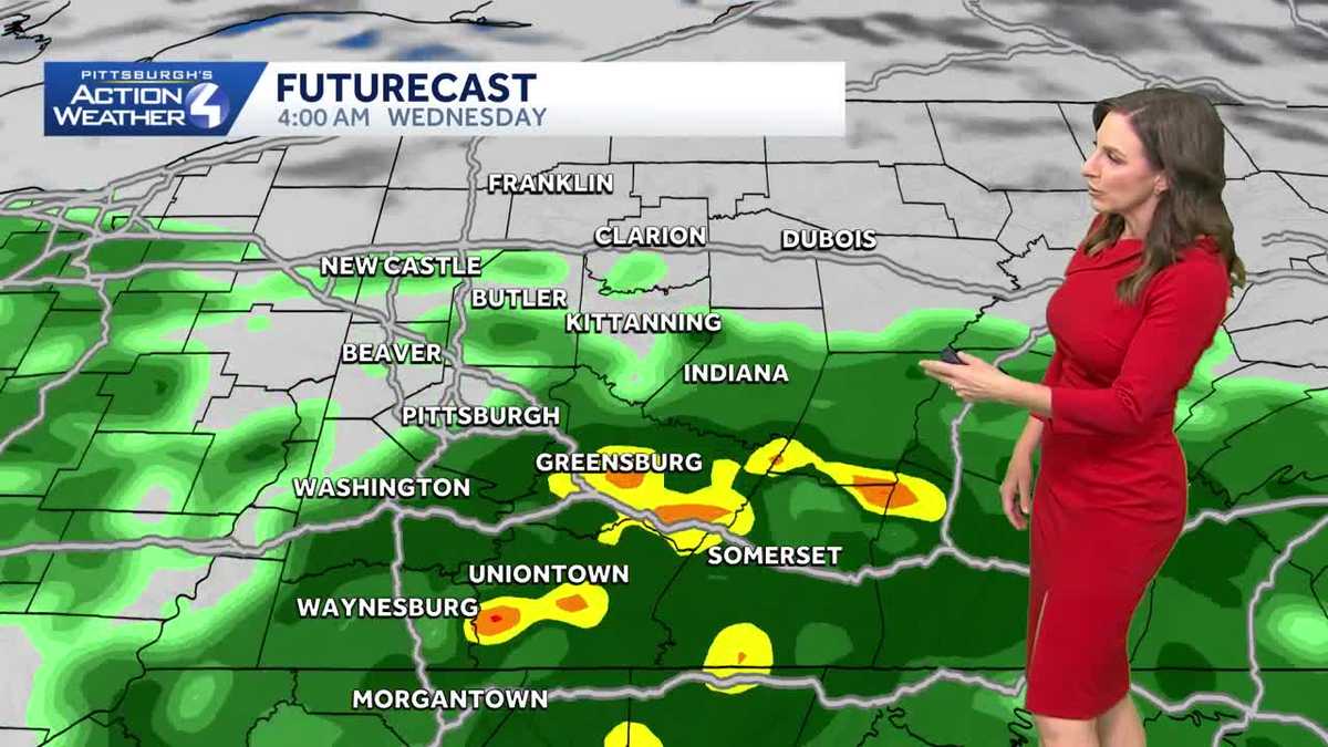
USPS LOCATIONS NATIONWIDE STARTING JUNE 1ST. RIGHT NOW, AS YOU GET UP AND GET GOING, IF YOU DO HAVE TO GET UP EARLY THIS MORNING, YOU WILL ENCOUNTER SOME AREAS OF PATCHY, DENSE FOG. BUT IF YOU’RE HEADING TO ANY OF THE PARADES TODAY OR ANY REMEMBRANCE SERVICES IS GOING TO BE REALLY NICE, WE’LL HAVE SOME DECREASING CLOUDS. STRAY SHOWERS SOUTH CAN’T BE RULED OUT TOMORROW, ESPECIALLY LATE AFTERNOON AND EVENING, THEN RAIN RETURNING ON WEDNESDAY, ESPECIALLY SOUTH. BUT IT DOES HAVE THE POTENTIAL TO PICK UP EVEN UP ALONG 422. SO SOMETHING WE’LL BE MONITORING A POTENTIAL UPGRADE TO AN IMPACT DAY AS WE FINE TUNE THE FORECAST. RIGHT NOW THOUGH, WE ARE DEALING WITH GLOOMY CONDITIONS. THE CLOUDS ARE AROUND AND YOU CAN SEE AS THE CAMERA POINTS EASTWARD, STILL A LITTLE BIT OF PATCHY FOG HOLDING ON, BUT IT IS IMPROVING NOW. GREENSBURG UP TO A TEN MILE VISIBILITY. SO THAT’S REALLY GOOD NEWS. DENSE FOG STILL LINGERING IN THE LAWRENCE BEAVER, ALSO UP INTO MERCER, VENANGO AND CLARION COUNTY. SOME OF THE HARDER HIT AREAS YESTERDAY WITH A LOT OF RAIN. EVEN GARRETT COUNTY HAS SOME PRETTY DENSE FOG THIS MORNING. WE ARE STILL SEEING A FEW SHOWERS, MAINLY EAST INTO CAMBRIA, SOMERSET, EVEN INTO GARRETT. EASTERN PORTIONS OF WESTMORELAND AND FAYETTE COUNTY. BUT THAT’S GOING TO CONTINUE TO DWINDLE DOWN AND MOVE ON OUT OF THE AREA. TEMPERATURES ARE PRETTY NICE AS YOU HEAD OUT. EVEN THE HUMIDITY IS UP A TAD. 63 RIGHT NOW IN PITTSBURGH AND MONROEVILLE, 64 AS YOU WAKE UP IN GREENSBURG, 59 IN FRANKLIN, 63 RIGHT NOW IN BEAVER AND WASHINGTON. WAKING UP AT 64 THIS MORNING. AS WE LOOK AT YOUR FOUR DAY FORECAST IN YOUR MEMORIAL DAY FORECAST, AGAIN, REALLY SHAPING UP TO BE A NICE AFTERNOON, EVEN THIS MORNING. NOT BAD WITH THE FOG AND CLOUD COVER, BUT WE WILL WATCH THESE CLOUDS DECREASE AND WE’LL WATCH OUR TEMPERATURES JUMP UP INTO THE UPPER 70S. SO REALLY GOING TO SHAPE UP TO BE A PRETTY NICE AFTERNOON. WE’LL BE FINE TUNING WEDNESDAY RIGHT NOW. SOME SCATTERED SHOWERS, ESPECIALLY SOUTH AS WE SHOW YOU HERE ON FUTURECAST. IT IS PICKING UP SOME OF THAT RAIN, TRYING TO NUDGE A LITTLE FURTHER NORTHWARD. AS WE CONTINUE THROUGH THE DAY. TODAY, WE WATCH THOSE CLOUDS MOVE ON OUT INTO THE OVERNIGHT. WE’LL HAVE PARTLY CLOUDY SKIES. SOME CLOUDS WILL START TO THICKEN UP THROUGH THE DAY ON TUESDAY. AGAIN, CAN’T RULE OUT A SPOTTY SHOWER. IF ANYTHING, A SPRINKLE OR TWO, ESPECIALLY ALONG INTERSTATE 70 ON SOUTH BETWEEN 4 AND 6:00, AND COULD EVEN HIT THE CITY OF WASHINGTON. THAT ROLLS ON OUT. WE’LL SEE OUR FIRST LITTLE WAVE OF RAIN COMING IN IN THE MORNING. AND AGAIN, IF THIS HOLDS, WE WILL UPGRADE THIS TO AN IMPACT DAY. JILL IS HERE AT NOON, SO SHE’LL BE WATCHING THIS AS WELL. AROUND 2:00. WE’LL STILL HAVE SOME SCATTERED SHOWERS AND ANOTHER LITTLE BATCH OF SOME HEAVY RAIN HITTING INTO WASHINGTON, WESTMORELAND, GREENE AND FAYETTE COUNTY. AS WE GET INTO THE EARLY EVENING. AND AGAIN, THAT ROLLS ON OUT. BY THE TIME WE GET INTO THURSDAY, THINGS WILL QUIET DOWN FOR US AND WE ARE GOING TO DRY OUT NOT ONLY ON THURSDAY, BUT ALSO INTO FRIDAY AND RIGHT NOW INTO THE UPCOMING WEEKEND LOOKS GREAT FOR US. TEMPERATURES WILL BE PRETTY SEASONAL INTO THE WEEKEND. IN THE MID 70S
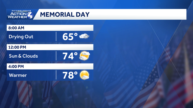
The last bit of rain moves out this morning but areas of patchy fog will linger through the AM. Some sunshine expected this afternoon too. Memorial Day forecastAreas of patchy fog for the morning but clouds are expected to decrease through the afternoon. Dry skies will cooperate for the start of parades and remembrance services and daytime highs will top off in the upper 70s.Mild end to MayTemperatures will stay warm to wrap up the month of May. Tuesday will be the warmest day of the week. A stalled boundary will bring rain chances back to the region on Wednesday. Most of the rain looks to be south of Pittsburgh but we can’t rule out some showers pushing northward, something we will be monitoring. We will dry out once again and remain comfortable through next weekend.MEMORIAL DAY: AM fog & clouds, Some PM Sun. High: 77°TUESDAY: Mostly sunny to partly cloudy, isolatedPM showers south. Warm. High: 82°WEDNESDAY: Mostly Cloudy. Warm. Sct’d rain, especially South of Pitt. High: 78°
The last bit of rain moves out this morning but areas of patchy fog will linger through the AM. Some sunshine expected this afternoon too.
Memorial Day forecast
Areas of patchy fog for the morning but clouds are expected to decrease through the afternoon. Dry skies will cooperate for the start of parades and remembrance services and daytime highs will top off in the upper 70s.
Mild end to May
Temperatures will stay warm to wrap up the month of May. Tuesday will be the warmest day of the week. A stalled boundary will bring rain chances back to the region on Wednesday. Most of the rain looks to be south of Pittsburgh but we can’t rule out some showers pushing northward, something we will be monitoring. We will dry out once again and remain comfortable through next weekend.
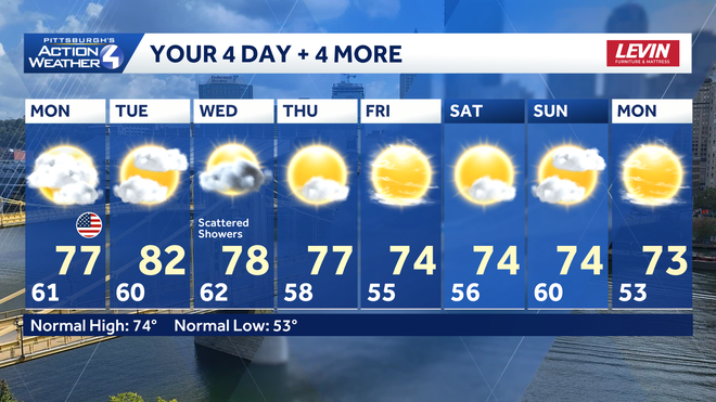
MEMORIAL DAY: AM fog & clouds, Some PM Sun. High: 77°
TUESDAY: Mostly sunny to partly cloudy, isolatedPM showers south. Warm. High: 82°
WEDNESDAY: Mostly Cloudy. Warm. Sct’d rain, especially South of Pitt. High: 78°