
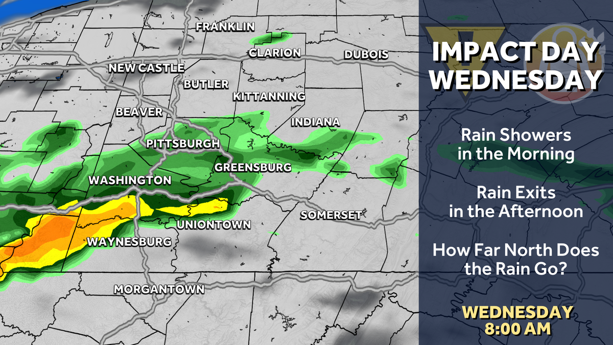
Western PA: Impact Day Wednesday for morning showers
Rain stays away for most until Wednesday.
TOMORROW AND THEN ANOTHER ONE FOR US AS WE HEAD INTO WEDNESDAY MORNING. NOWHERE NEAR THE RAIN THAT WE SAW THOUGH THIS WEEKEND FOR US, WE’RE WATCHING A SHOWER CHANCE SOUTH OF THE CITY OF PITTSBURGH. TOMORROW IN THE AFTERNOON. IT SHOULD GENERALLY BE ISOLATED IN NATURE, BUT A COUPLE OF SHOWERS WILL DEVELOP. AGAIN, NOT A MAJOR DEAL. TOMORROW, WEDNESDAY WE’RE FIRING OFF THE IMPACT A MAINLY BECAUSE SHOWERS WILL BE AROUND IN AND SOUTH OF PITTSBURGH FOR THE MORNING COMMUTE. SO WE WENT OUT THE DOOR. BUT WE’LL SEE SUNSHINE BACK IN THE AFTERNOON. AND THEN WE START A REALLY NICE STRETCH ON THURSDAY. IN FACT, ONCE WE GET PAST WEDNESDAY MORNING, WE COULD NOT SEE RAIN AGAIN, POTENTIALLY FOR A WEEK AND A HALF OR SO. SO A LONG DRY STRETCH LOOKS TO BE ON THE HORIZON FOR US. 82 IS WHERE WE WILL MAKE IT TOMORROW. AGAIN, WE’RE WATCHING FOR THAT SHOWER CHANCE. THE BEST CHANCE IS SOUTH OF PITTSBURGH. NORTH OF PITTSBURGH. YOU’RE STAYING DRY AND THAT’S LIKELY TRUE ON WEDNESDAY AS WELL. THOSE OF YOU NORTH OF PITTSBURGH WILL LIKELY REMAIN DRY. CITY SOUTH WILL SEE THE MORNING SHOWERS, AND THEN IT’S SEASONABLY COMFORTABLE 73 FOR US ON THURSDAY, 72 FOR US ON FRIDAY. AND WE KEEP THAT STRETCH GOING THROUGH THE WEEKEND. SATURDAY AND SUNDAY WILL BE IN THE MIDDLE 70S. THAT IS JUST ABOUT WHERE WE SHOULD BE FOR THIS TIME OF YEAR. AND THEN WE’LL BUMP INTO THE MIDDLE AND UPPER 70S AS WE HEAD INTO NEXT WEEK WITH AMPLE SUNSHINE AGAIN. ONCE WE GET PAST OUR RAIN CHANCES TOMORROW AND WEDNESDAY, A DRY STRETCH SETS UP ACROSS WESTERN PENNSYLVANIA. SO WE’LL START THE CLOCK TOMORROW AT NOON AGAIN SOUTH OF THE CITY. WE’LL BE WATCHING FOR A COUPLE OF ISOLATED SHOWERS DEVELOPING. THEY SHOULD BE FEW AND FAR BETWEEN, BUT SOME SHOWERS WILL DEVELOP THROUGH THE AFTERNOON. THOSE WILL LIKELY FIZZLE OUT AS WE GET PAST SUNSET CLOUDS. STAY WITH US. THEN. WEDNESDAY MORNING, RAIN SHOWERS DEVELOP AGAIN. BEST CHANCE IS CITY SOUTHWARD AND THEY’LL BE AROUND FOR THE MORNING COMMUTE. THAT’S WHY IT’S AN IMPACT DAY. AS WE GET TOWARDS LUNCHTIME, THOUGH, THESE SHOWERS SHOULD START DRIFTING SOUTH AND EAST AND THEN SUNSHINE WILL RETURN FROM NORTH TO SOUTH. WE’LL HAVE TO KEEP AN EYE ON LOCATIONS SOUTH OF PITTSBURGH, THOUGH, AS WE COULD POTENTIALLY SEE ANOTHER INCH OR SO IN ISOLATED SPOTS, WHICH, WITH THE RAIN WE GOT THIS WEEKEND, COULD CAUSE SOME LOCALIZED FLOODING CONCERNS. SO WE’LL WATCH THAT, ESPECIALLY AS WE HEAD INTO WEDNESDAY. PARTLY CLOUDY SKIES FOR US ON ACTION. CAM 74 IS THE CURRENT TEMPERATURE. WINDS ARE FROM THE NORTH NORTHEAST AT SEVEN MILES PER HOUR. PRETTY NICE NIGHT IN STORE FOR US TONIGHT. WE’RE DROPPING DOWN INTO THE UPPER 50S. WE’LL FINISH IN THE LOWER 80S TOMORROW. AN
Western PA: Impact Day Wednesday for morning showers
Rain stays away for most until Wednesday.

Updated: 4:28 PM EDT May 25, 2026
A mix of sun and clouds will remain with us through the middle of the week. The rain will stay away for most until Wednesday. Shower chances Tuesday, Impact Day WednesdayUpcoming rain chances will all come down to location. Isolated showers could pop up south of Pittsburgh Tuesday afternoon. A better rain chance is ahead on Wednesday. A stalled boundary to our south will send more wet weather our way. The question is how far north will the rain reach? Given proximity to the front, areas to the south of Allegheny County will be the wettest. It looks like the best time to see rain will be Wednesday morning until about midday from Pittsburgh south, prompting the Impact Day. We will dry out in the afternoon.Mild end to MayTemperatures will stay warm to wrap up the month of May. Tuesday will be the warmest day of the week. We will dry out and cool slightly after Wednesday’s showers. High temperatures will trend downward into the lower 70s by late week.TONIGHT: Mostly cloudy and mild. Low: 58°.TUESDAY: Mostly cloudy with isolated afternoon showers south. Warm. High: 82°, low: 63°.WEDNESDAY – Impact Day: Morning rain showers, especially Pittsburgh and south, with afternoon sunshine. High: 78°, low: 58°.THURSDAY: Sun and clouds. Mild with lower humidity. High: 73°, low: 50°.
PITTSBURGH —
A mix of sun and clouds will remain with us through the middle of the week. The rain will stay away for most until Wednesday.
Shower chances Tuesday, Impact Day Wednesday
Upcoming rain chances will all come down to location. Isolated showers could pop up south of Pittsburgh Tuesday afternoon. A better rain chance is ahead on Wednesday.
Hearst Owned
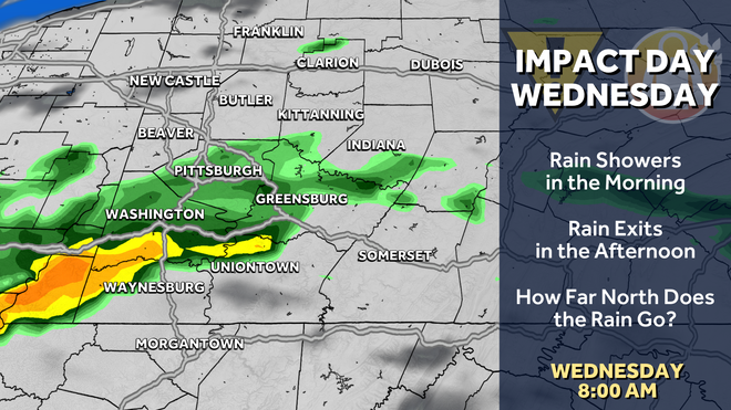
Showers look to be around Wednesday morning during the commute, prompting the Impact Day.
A stalled boundary to our south will send more wet weather our way. The question is how far north will the rain reach? Given proximity to the front, areas to the south of Allegheny County will be the wettest. It looks like the best time to see rain will be Wednesday morning until about midday from Pittsburgh south, prompting the Impact Day. We will dry out in the afternoon.
Mild end to May
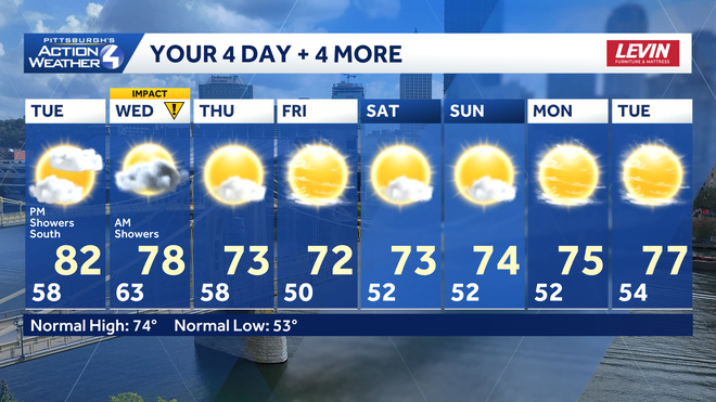
Temperatures will stay warm to wrap up the month of May. Tuesday will be the warmest day of the week. We will dry out and cool slightly after Wednesday’s showers. High temperatures will trend downward into the lower 70s by late week.
Hearst Owned
Pittsburgh turns quite comfortable with more sunshine to send out May.
TONIGHT: Mostly cloudy and mild. Low: 58°.
TUESDAY: Mostly cloudy with isolated afternoon showers south. Warm. High: 82°, low: 63°.
WEDNESDAY – Impact Day: Morning rain showers, especially Pittsburgh and south, with afternoon sunshine. High: 78°, low: 58°.
THURSDAY: Sun and clouds. Mild with lower humidity. High: 73°, low: 50°.