
Increasing Clouds Today; Few Showers Wednesday In South Central Pennsylvania
It will be sticky today and humid tomorrow, then humidity will drop for the rest of the week.
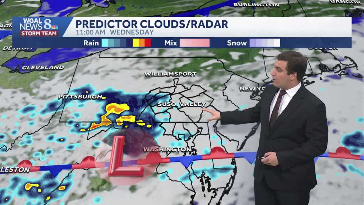
THEY MAY BE. IN HOLLYWOOD, I’M DAVID DANIEL. NOW THE WGAL NEWS EIGHT STORM TEAM FORECAST WITH METEOROLOGIST MIKE SUSKO. GOOD AFTERNOON EVERYONE. HERE’S A LOOK AT THE ACTUAL SYNOPTIC WEATHER MAP FROM D-DAY ITSELF HERE. AND YOU SEE THIS BIG CIRCLE OFF OF THE COAST OF ENGLAND. THAT WAS THE LOW PRESSURE SYSTEM THAT THEY WERE WATCHING FOR THE INVASION ITSELF AND ENDED UP PULLING AWAY ON JUNE 6TH. AND THAT IS WHAT ENDED UP GIVING THEM THE CLEARING THEY NEEDED IN ORDER TO LAUNCH D-DAY THERE ON NORMANDY OF FRANCE. SO WEATHER PLAYS A BIG ROLE, ESPECIALLY WHEN IT COMES TO MILITARY OPERATIONS AROUND THE WORLD. BUT BACK HERE AT HOME, WE WILL BE WATCHING FOR SOME SHOWERS TODAY AND ALSO TONIGHT. BUT TOMORROW’S HEAVY RAIN DOES LOOK LIKE IT STAYS TO THE SOUTH. SO LET’S LOOK AT THIS ON PREDICTOR AS WE GO THROUGH THE EVENING HOURS. THE SPOTTY SHOWER THERE NEAR FRANKLIN AND ADAMS COUNTY. NOT OUT OF THE QUESTION, BUT THIS FRONT THAT YOU SEE TO THE SOUTH ACTUALLY STAYS TO THE SOUTH A LITTLE BIT MORE AS WE GO INTO TOMORROW. AND THAT KEEPS THE HEAVY RAIN THAT WE INITIALLY THOUGHT WAS GOING TO HAPPEN TOMORROW MORNING TO THE SOUTH. SO WE KIND OF DODGE A LITTLE BIT OF A BULLET ON THAT ONE FOR THE MORNING COMMUTE. SO YOU CAN SEE THE MORNING COMMUTE, IN FACT, MAY EVEN BE NOW A FEW SHOWERS THAT ARE POTENTIALLY EVEN DRY FOR SOME OF YOU. BUT AS WE GO INTO TOMORROW AFTERNOON, WE WILL CONTINUE TO WATCH FOR A FEW SPOTTY SHOWERS AND SCATTERED SHOWERS THERE, ESPECIALLY SOUTH OF THE TURNPIKE. AS WE HEAD TOWARDS THE TWO THREE, 4:00 HOUR ON YOUR WEDNESDAY. AND THEN THIS WILL FINALLY PULL AWAY. ONCE WE HEAD INTO THURSDAY, A COLD FRONT WILL DROP IN FROM THE NORTH, AND FROM THAT POINT ON IT IS GOING TO BE DRY. IT’S SUNNY AND TEMPERATURES ARE NOT GOING TO BE TOO BAD EITHER. BUT YOU WILL ALSO NOTICE TODAY AND TOMORROW THE HUMIDITY. IT’S STICKY OUT THERE RIGHT NOW. IT WILL BE HUMID TOMORROW AS WELL THROUGHOUT YOUR WEDNESDAY, REGARDLESS IF YOU GET THE RAIN OR NOT, THEN THE HUMIDITY WILL DROP TO COMFORTABLE LEVELS THURSDAY AND FRIDAY TO END THE WEEK. BUT LANCASTER, RIGHT NOW WE’VE GOT A MIX OF SUN AND CLOUDS OUT THERE. TEMPERATURES ARE ALREADY IN THE 70S, A FEW PLACES LEBANON AND GETTYSBURG AT IN THE LOW 80S, 76. IN LANCASTER, IT’S 74 IN HARRISBURG, 76 FOR CARLISLE, 79 UP IN LEWISTOWN AND 75 IN YORK. STORM TEAM LIVE RADAR NETWORK. QUIET RIGHT NOW, THOUGH. SOME SHOWERS THERE ALONG THAT FRONTAL BOUNDARY. BUT THAT FRONT AGAIN STAYS NEARBY TO THE SOUTH. AND THAT KEEPS THE HEAVY RAIN AWAY FOR WEDNESDAY AS WELL. SO FOR HIGH SCHOOL GRADUATIONS TONIGHT, IF YOU ARE GRADUATING TONIGHT, CONGRATULATIONS. WE WILL BE SEEING THOSE TEMPERATURES RIGHT AROUND 78 DEGREES AT 6:00. A STRAY SHOWER, AGAIN, NOT OUT OF THE QUESTION, BUT MOST OF THAT WILL STAY TO THE WEST OF THE SUSQUEHANNA RIVER. IT WILL BE HUMID, THOUGH, NO MATTER WHAT. TONIGHT WILL BE IN THE MID 60S ACROSS THE AREA. MOSTLY CLOUDY WITH A FEW SCATTERED SHOWERS TOMORROW, A FEW SHOWERS, BUT THAT HEAVY RAIN STAYS TO THE SOUTH AS WE HEAD INTO YOUR WEDNESDAY, WITH HIGHS RIGHT AROUND THE UPPER 70S. SO THAT’S WHY WEDNESDAY WE ARE DROPPING THE IMPACT DAY THERE BECAUSE IT LOOKS LIKE THE HEAVY RAIN STAYS AWAY. BUT THURSDAY AND BEYOND WE’RE IN THE 70S, 76 ON THURSDAY AND FRIDAY, A LITTLE BIT MORE SUNSHINE FRIDAY COMPARED TO THURSDAY. THE WEEKEND LOOKING FANTASTIC. SO IF YOU HAVE ANY SUMMER LIKE PLANS FOR THE WEEKEND, IT’S GOING TO BE A LITTLE COOLER THAN AVERAGE, BUT AT LEAS
Increasing Clouds Today; Few Showers Wednesday In South Central Pennsylvania
It will be sticky today and humid tomorrow, then humidity will drop for the rest of the week.

Updated: 1:18 PM EDT May 26, 2026
Good afternoon,Except for a stray evening shower, we will remain dry across the Susquehanna Valley this afternoon with increasing clouds. High temperatures will reach near 80°.Tonight, lows will fall to the mid-60s under mostly cloudy skies. You’ll notice it feels more humid. Scattered showers will move through the area as a stalled boundary lingers near the PA/MD state line.The heaviest rain tomorrow will stay to our south. Expect a few showers throughout the day, higher humidity levels, and highs in the upper 70s. Rain totals from tonight and tomorrow will amount to a tenth or two of an inch.After a cold front passes early Thursday, more refreshing air will move into the Susquehanna Valley. It will be cooler and more comfortable, with highs in the mid-70s under partly sunny skies.Friday will feature sunshine, low humidity, and a high of 76.By Saturday, a reinforcing shot of cool, comfortable air will move into the region. It will be breezy and comfortable on Saturday and Sunday. Expect highs in the low 70s both days.Next week, our dry stretch continues. Highs will gradually warm a few degrees each day, reaching 80 degrees by Thursday. Average highs are in the upper 70s at the beginning of June.Have a great day!
Good afternoon,
Except for a stray evening shower, we will remain dry across the Susquehanna Valley this afternoon with increasing clouds. High temperatures will reach near 80°.
Tonight, lows will fall to the mid-60s under mostly cloudy skies. You’ll notice it feels more humid. Scattered showers will move through the area as a stalled boundary lingers near the PA/MD state line.
The heaviest rain tomorrow will stay to our south. Expect a few showers throughout the day, higher humidity levels, and highs in the upper 70s. Rain totals from tonight and tomorrow will amount to a tenth or two of an inch.
After a cold front passes early Thursday, more refreshing air will move into the Susquehanna Valley. It will be cooler and more comfortable, with highs in the mid-70s under partly sunny skies.
Friday will feature sunshine, low humidity, and a high of 76.
By Saturday, a reinforcing shot of cool, comfortable air will move into the region. It will be breezy and comfortable on Saturday and Sunday. Expect highs in the low 70s both days.
Next week, our dry stretch continues. Highs will gradually warm a few degrees each day, reaching 80 degrees by Thursday. Average highs are in the upper 70s at the beginning of June.
Have a great day!