
Impact Day: Rain for the AM Commute
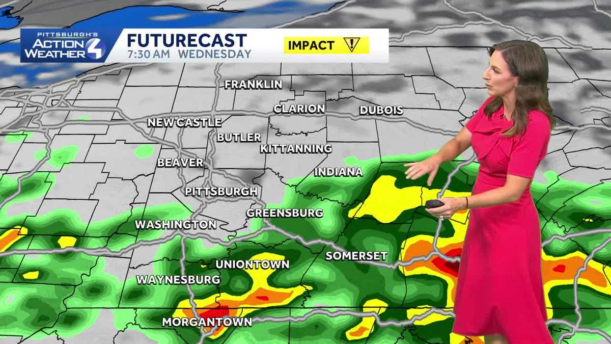
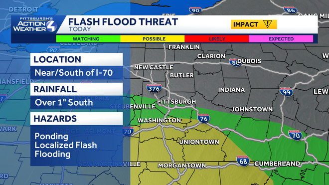
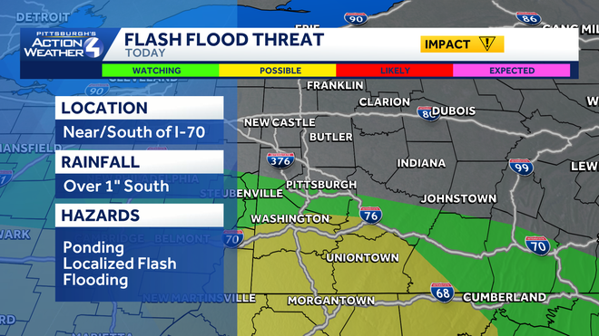
MARS. WEXFORD, PINE TOWNSHIP RELATIVELY DRY RIGHT NOW, BUT MORE RAIN WILL BE EDGING IN HERE IN THE NEXT 15 TO 20 MINUTES. NOW WE DO HAVE A FLOOD WATCH IN PLACE FOR WASHINGTON, GREENE, FAYETTE AND SOMERSET THAT REMAINS IN PLACE UNTIL 10:00 TONIGHT. BUT ALREADY A FLOOD WARNING INTO GARRETT COUNTY, KEEPING AN EYE ON SMALL CREEKS AND STREAMS AGAIN. THAT IS GOING TO BE THE HARDEST HIT AREAS. THE GROUND IS ALREADY SATURATED FROM OVER THE WEEKEND, AND NOW POCKETS OF HEAVY RAIN CONTINUING TO MOVE THROUGH. SO AS WE TIME IT OUT HERE ON FUTURECAST, STILL SOME HEAVY RAIN UNTIL ABOUT 9:00. THEN THINGS WILL QUIET DOWN FOR US. CLOUDS WILL BREAK UP A LITTLE BIT, BUT AS THIS FRONT SWEEPS THROUGH FROM NORTH TO SOUTH, THERE IS STILL A SMALL CHANCE FOR A POP UP SHOWER OR NON-SEVERE STORM INTO WASHINGTON, GREENE AND FAYETTE THAT COULD EVEN CLIP PARTS OF ALLEGHENY AND WESTMORELAND. EVEN THOUGH OUR FUTURECAST IS NOT PICKING UP, THERE’S THAT CHANCE AS THAT FRONT SWEEPS THROUGH VERY ISOLATED. MOST OF THE AREA WILL STAY DRY, AND THEN WE’LL CONTINUE TO STAY ON THE DRY SIDE A BIT MORE COMFORTABLE AS WE FINISH OUT THE WEEK. THERE IS A POSSIBILITY FOR THE FLASH FLOODING. AS I WAS TALKING ABOUT STILL SOME OF THE HARDEST HIT AREAS ALONG INTERSTATE 70 INTO WASHINGTON, ALL OF GREENE DOWN INTO MORGANTOWN, EVEN SOUTHERN PORTIONS OF WESTMORELAND AND FAYETTE COUNTY. SO SMALL CREEKS AND STREAMS, POOR DRAINAGE AREAS AND A LOT OF PONDING ON THE ROADWAYS COULD SEE AN ADDITIONAL INCH OF RAINFALL THIS MORNING IN THOSE AREAS. THERE’S YOUR FOUR DAY FORECAST. WE’LL GET THROUGH THIS IMPACT DAY, THEN WILL BE SMOOTH SAILING THURSDAY, FRIDAY, EVEN INTO THE UPCOMING WEEKEND MAY FEEL A LITTLE BIT COOLER. THAT HUMIDITY DIPS DOWN A BIT AND TEMPERATURES PRETTY SEASONAL INTO THE MID 70S. IT IS GLOOMY OUT THERE. IT’S NOT JUST THE RAIN, IT’S ALSO LOW VISIBILITY AS THOSE RAIN SHOWERS MOVE THROUGH THE AREA. TEMPERATURES ARE PRETTY COMFORTABLE 67 RIGHT NOW. PITTSBURGH AND MONROEVILLE 63 IN BUTLER, GREENSBURG WAKING UP AT 68. SO BREAKING DOWN YOUR FOUR DAY PLUS FOUR MORE FORECAST. IF YOU’RE HEADING TO THE BUC-EE’S GAME LATER TODAY SHOULD BE NICE. WE’RE GOING TO SEE THE WORST OF THIS THROUGH THE MORNING COMMUTE. WE’LL HAVE A VERY NICE WEEKEND AHEAD AND FINGERS CROSSED. AS OF RIGHT NOW, AS WE GET INTO THE MONTH OF JUN
Today is an Impact Day with widespread rain that is heavy at times. The majority of the heavy rain will be south of Pittsburgh.Impact Day Wednesday: Morning RainA Flood Watch is in effect until 4 pm. for Fayette, Greene, Washington, Monongalia, Preston, and Garrett Counties.Given proximity to the front, areas to the south of Allegheny County will be the wettest. The best time to see rain will be early Wednesday morning and most of the rain will depart by noon. Heavier rain near I-70 to the West Virginia border could lead to isolated flash flooding. A slight chance for a shower or storm to pop late afternoon, especially East of the city, but most of the area will remain dry. Sunny and comfortable heading into JuneWe will dry out and cool slightly on Thursday. High temperatures will trend downward into the mid 70s. High pressure becomes our dominant weather feature, so expect sunshine and relatively dry conditions into the start of June.TODAY – Impact Day: Rain, especially south of Pittsburgh this morning. Mostly cloudy and mild afternoon. High: 78°TONIGHT: Partly cloudy. Low 58°THURSDAY: Pleasant with sunshine and clouds, breezy. High: 74°, low: 52°.FRIDAY: Mostly sunny and comfortable. High: 75°, low: 53°.
Today is an Impact Day with widespread rain that is heavy at times. The majority of the heavy rain will be south of Pittsburgh.
Impact Day Wednesday: Morning Rain
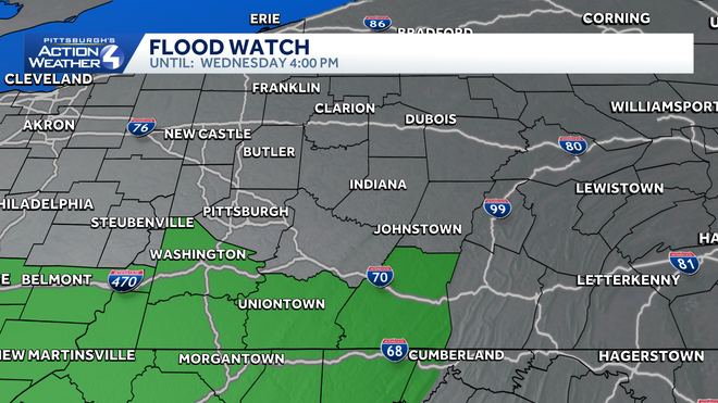
A Flood Watch is in effect until 4 pm. for Fayette, Greene, Washington, Monongalia, Preston, and Garrett Counties.
Given proximity to the front, areas to the south of Allegheny County will be the wettest. The best time to see rain will be early Wednesday morning and most of the rain will depart by noon. Heavier rain near I-70 to the West Virginia border could lead to isolated flash flooding. A slight chance for a shower or storm to pop late afternoon, especially East of the city, but most of the area will remain dry.
Sunny and comfortable heading into June
We will dry out and cool slightly on Thursday. High temperatures will trend downward into the mid 70s. High pressure becomes our dominant weather feature, so expect sunshine and relatively dry conditions into the start of June.
TODAY – Impact Day: Rain, especially south of Pittsburgh this morning. Mostly cloudy and mild afternoon. High: 78°
TONIGHT: Partly cloudy. Low 58°
THURSDAY: Pleasant with sunshine and clouds, breezy. High: 74°, low: 52°.
FRIDAY: Mostly sunny and comfortable. High: 75°, low: 53°.