
Good evening!Rest Of The Work WeekAfter a day of mixed conditions, clouds begin to decrease as we head into the evening. Conditions will remain muggy, with temperatures slowly falling to the mid 70s. Isolated thunderstorms remain a threat for areas southwest of Harrisburg in Adams and Franklin Counties. Similar conditions will continue into the night with mostly cloudy skies gradually clearing as the night goes on. Temperatures are mild, reaching 64°, and the humidity is dropping. We’re set up for a pleasant Thursday, though, as the sun returns and helps to warm us back up to 76°. A light breeze from Thursday continues into Friday, and alongside mostly sunny skies, sets us up for a rather comfortable day, with temperatures reaching 80°. This WeekendThis weekend is shaping up to be a much nicer one than that of Memorial Day weekend. Skies are clearing out, and there is no precipitation in sight, allowing us to enjoy some outdoor activities. Saturday will continue to be breezy, and with the aid of partly sunny skies, will help to keep the area cool with temperatures dropping to the 70° mark. Sunday continues to be pleasant, the sun will come back out to give us another enjoyable day, and temperatures will rise again to the mid-70s.Early Next WeekThe trend of warmer, more seasonable weather continues for the majority of next week. Monday looks to be the coolest day of the work week with highs in the low 70s. There is also a chance of scattered showers under a mostly cloudy sky. It also marks the official start of the 2026 Atlantic hurricane season, which NOAA predicts to be below-average in activity. We resume our stretch of partly sunny, more comfortable, and seasonable days, with temperatures reaching the mid-70s both Tuesday and Wednesday. Overnight temperatures also remain cool, with temperatures ranging from 54° on Monday to 58° on Wednesday.Late Next Week We return to the 80s and remain dry for the end of the work week. Saturday will offer our next chance for scattered showers and thunderstorms. Stay tuned for updates as timing may change.Have a great night!
Good evening!
Rest Of The Work Week
After a day of mixed conditions, clouds begin to decrease as we head into the evening. Conditions will remain muggy, with temperatures slowly falling to the mid 70s. Isolated thunderstorms remain a threat for areas southwest of Harrisburg in Adams and Franklin Counties.
Similar conditions will continue into the night with mostly cloudy skies gradually clearing as the night goes on. Temperatures are mild, reaching 64°, and the humidity is dropping.
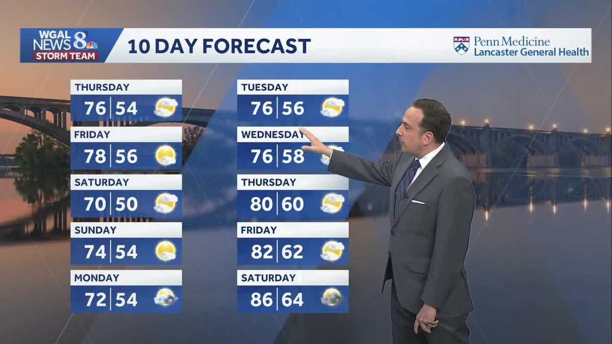
We’re set up for a pleasant Thursday, though, as the sun returns and helps to warm us back up to 76°.
A light breeze from Thursday continues into Friday, and alongside mostly sunny skies, sets us up for a rather comfortable day, with temperatures reaching 80°.
This Weekend
This weekend is shaping up to be a much nicer one than that of Memorial Day weekend. Skies are clearing out, and there is no precipitation in sight, allowing us to enjoy some outdoor activities.
Saturday will continue to be breezy, and with the aid of partly sunny skies, will help to keep the area cool with temperatures dropping to the 70° mark.
Sunday continues to be pleasant, the sun will come back out to give us another enjoyable day, and temperatures will rise again to the mid-70s.
Early Next Week
The trend of warmer, more seasonable weather continues for the majority of next week.
Monday looks to be the coolest day of the work week with highs in the low 70s. There is also a chance of scattered showers under a mostly cloudy sky. It also marks the official start of the 2026 Atlantic hurricane season, which NOAA predicts to be below-average in activity.
We resume our stretch of partly sunny, more comfortable, and seasonable days, with temperatures reaching the mid-70s both Tuesday and Wednesday. Overnight temperatures also remain cool, with temperatures ranging from 54° on Monday to 58° on Wednesday.
Late Next Week
We return to the 80s and remain dry for the end of the work week. Saturday will offer our next chance for scattered showers and thunderstorms. Stay tuned for updates as timing may change.
Have a great night!