
A Cool Saturday Heading More Seasonable Weather in South Central Pennsylvania
Dry, more seasonable weather is in store for next week!
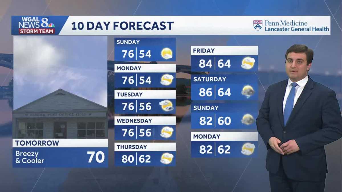
CONCERNED ABOUT THE EFFECTS ON TOURISM. NOW THE WGAL NEWS EIGHT STORM TEAM FORECAST, WITH METEOROLOGIST MIKE SUSKO. AND GOOD EVENING, EVERYONE. HERE’S A LOOK AT THE PART OF THE TEN DAY FORECAST AS WE GO INTO TOMORROW. IT’S BREEZY AND COOLER TEMPERATURES RIGHT AROUND 70 DEGREES. AND THEN SUNDAY 76 FOR THE HIGH. AND YOU CAN SEE IT’S GOING TO BE A FAIRLY NICE WEEKEND COMING OUR WAY MONDAY 76 AS WELL. THERE’S A SPOTTY SHOWER CHANCE AS WE HEAD INTO YOUR TUESDAY, BUT MOST OF NEXT WEEK IS REALLY GOING TO BE REALLY PLEASANT. EVEN WHEN WE LOOK AT FRIDAY HERE OF THE END OF THE WEEK, IT’S GOING TO BE NICE. NOW, AS WE HEAD TO THE FOLLOWING WEEKEND, THAT’S WHEN OUR STORM CHANCES MAKE A RETURN TO THE FORECAST. BUT UNTIL THEN, ENJOY THIS NICE BLUE SKY ACROSS LANCASTER RIGHT NOW AND TEMPERATURES ARE IN THE 70S. IT’S 76 IN HARRISBURG, 76 LANCASTER. SAME THING IN QUARRYVILLE. ELIZABETHTOWN AT 76, WE’RE AT 78 IN EPHRATA, 76 IN HANOVER, 78 FOR CHAMBERSBURG AND 77 FOR MIFFLINTOWN, LANESVILLE OR LANDISBURG THERE, AND ALSO IN CARLISLE. HERE’S A LOOK AT YOUR FORECAST FOR THIS EVENING. WE WILL BE SEEING THOSE TEMPERATURES REMAIN IN THE 70S THROUGHOUT THE CELEBRATIONS ACROSS THE SUSQUEHANNA VALLEY FOR THE CLASS OF 2026. A PLEASANT NIGHT AND REALLY A PERFECT NIGHT FOR THE CELEBRATIONS HERE. STORM TEAM. LABORATORY NETWORK. IT IS QUIET. THERE’S NOTHING NEARBY HERE. YOU HAVE TO GO ALL THE WAY TO NEW YORK AND NEW ENGLAND FOR ANY TYPE OF RAIN AND CLOUDS HERE. WITH THIS LOW PRESSURE SYSTEM. NOW THE COLD FRONT ITSELF DOES PUSH THROUGH THE SUSQUEHANNA VALLEY. AS WE GO THROUGH THE NIGHT TONIGHT. BUT IT’S NOT GOING TO BRING US RAIN AND VERY LOW CLOUD COVER EVEN, BECAUSE WE WILL END UP SEEING THOSE COOLER TEMPERATURES. NOW IT WILL ALSO TURN UP THE WINDS ACROSS OUR AREA NORTHWEST 10 TO 20MPH, WITH LOWS AROUND 54. UNDER A MOSTLY CLEAR SKY TONIGHT. TOMORROW. MIX OF SUN AND CLOUDS. IT’S BREEZY AND COOLER. SOME OF YOU, ESPECIALLY IN THE HIGHER ELEVATIONS, MAY ONLY GET UP TO AROUND 68, BUT IT’S STILL GOING TO BE A PRETTY DECENT DAY EVEN WITH THAT NORTHWEST BREEZE AROUND 10 TO 20MPH. SO HERE’S A LOOK AT THE PREDICTOR AS WE GO THROUGH THE NIGHT TONIGHT. HIGH PRESSURE IS IN CONTROL. THERE COMES THAT COLD FRONT PUSHING THROUGH FOR THE NIGHT AND INTO TOMORROW MORNING. JUST A COUPLE CLOUDS THERE. NORTHEASTERN PENNSYLVANIA NEAR THE WYOMING VALLEY. AND THEN AS WE GO THROUGH TOMORROW, AROUND LUNCHTIME, A COUPLE CLOUDS HERE AND THERE, ESPECIALLY NORTH OF THE TURNPIKE, BUT OTHERWISE PLENTY OF SUNSHINE, ESPECIALLY WEST OF THE RIVER THERE AS WE HEAD INTO YOUR SUNDAY, HIGH PRESSURE WILL COME BACK INTO CONTROL. THAT WILL CALM DOWN THE WINDS AND ALSO LEAD TO A BEAUTIFUL DAY ON SUNDAY. EVEN WARMER SUNDAY COMPARED TO SATURDAY. AS WE GO INTO THE WEEKEND. SO FOR THE NEXT COUPLE OF DAYS TOMORROW, A LITTLE BIT ON THE COOL SIDE, AT LEAST IN MY OPINION. WHEN IT COMES TO THE POOL, IF YOU HAVE A HEATER, THAT’S GOOD NEWS. BUT HERE’S A LOOK AT SUNDAY 76 DEGREES COMFORTABLE WILL BE NEAR AVERAGE. SAME THING ON MONDAY. SO IF YOU WANT TO GO OUT TO THE POOL, YOU’VE GOT THE GREEN LIGHT ALL WEEKEND HERE. IT’S ALSO GOING TO BE WHEN WE SEE MAY’S SECOND FULL MOON. THE BLUE BLUE MOON WILL BE ON SUNDAY MORNING AT 445 IN THE MORNING. SO IF YOU WANT TO GET UP EARLY ON SUNDAY, YOU CAN DO SO. FULL MOONS OR SECOND FULL MOON LIKE THIS OCCURS ONCE EVERY TWO AND A HALF TO THREE YEARS. SO IT’S NOT EVERY TIME THAT WE GET TO SEE THIS ACROSS THE AREA. AND THE FORECAST LOOKING GOOD. WE’LL HAVE LIGHT WINDS AS WE GO INTO SATURDAY NIGHT AND SUNDAY MORNING. TEMPERATURES SEASONABLY CHILLY AROUND 50 DEGREES FOR THAT OVERNIGHT LOW AS WE HEAD INTO OUR SUNDAY MORNING SUNDAY ITSELF, IT’S COMFORTABLE 76 FOR THAT HIGH SEASONABLE ON MONDAY. THERE TO SPY SHOWER CHANCE MAYBE ON TUESDAY. BUT MOST OF THAT STAYS TO OUR NORTH AND EAST AS WE HEAD INTO THE LATER PART OF NEXT WEEK, WE SEE THE TEMPERATURES STARTING TO CLIMB UP AGAIN, GET BACK INTO THE LOW 80S. I KNOW A FEW PEOPLE WHO ARE HAPPY ABO
A Cool Saturday Heading More Seasonable Weather in South Central Pennsylvania
Dry, more seasonable weather is in store for next week!

Updated: 4:52 PM EDT May 29, 2026
Good evening!A mostly sunny, warm evening is in store to help close out what was overall a beautiful, refreshing day. As we inch closer to tonight, temperatures will continue to fall into the mid-50s, and a breeze will begin to pick up. These conditions will continue into tomorrow as a cold front moves through, bringing 10-20 mph winds. Expect a cooler day with temperatures around 70°, and some clouds in the afternoon. High pressure will help clear us out come Sunday, with temperatures rising to the mid-70s and the breeze dying down.If you are looking to catch a glimpse of the Blue Moon Sunday morning, it’s shaping up to be a great weekend, with clear skies giving us perfect viewing conditions. The more seasonable weather continues for the first half of next week, with temperatures remaining around 76° across the board. Overnight temperatures look the same, with temperatures in the mid 50s from Monday through Wednesday. Expect partly cloudy skies every day, with only a spotty shower chance on Tuesday looking to break up the pattern. Reminder that Monday is the official start of the 2026 Atlantic Hurricane season! The tropics look to mirror us here at home, with no activity occurring just yet.Things begin to warm up as we head into the second half of next week, with temperatures rising back into the 80s. Though we are also looking at a potential return to rainy conditions over the weekend.Have a great night!
Good evening!
A mostly sunny, warm evening is in store to help close out what was overall a beautiful, refreshing day. As we inch closer to tonight, temperatures will continue to fall into the mid-50s, and a breeze will begin to pick up.
These conditions will continue into tomorrow as a cold front moves through, bringing 10-20 mph winds. Expect a cooler day with temperatures around 70°, and some clouds in the afternoon. High pressure will help clear us out come Sunday, with temperatures rising to the mid-70s and the breeze dying down.
If you are looking to catch a glimpse of the Blue Moon Sunday morning, it’s shaping up to be a great weekend, with clear skies giving us perfect viewing conditions.
The more seasonable weather continues for the first half of next week, with temperatures remaining around 76° across the board. Overnight temperatures look the same, with temperatures in the mid 50s from Monday through Wednesday. Expect partly cloudy skies every day, with only a spotty shower chance on Tuesday looking to break up the pattern.
Reminder that Monday is the official start of the 2026 Atlantic Hurricane season! The tropics look to mirror us here at home, with no activity occurring just yet.
Things begin to warm up as we head into the second half of next week, with temperatures rising back into the 80s. Though we are also looking at a potential return to rainy conditions over the weekend.
Have a great night!