
Western PA: Warm up kicks off today
The forecast remains dry until the weekend. Rain now looks to impact plans starting Saturday afternoon.
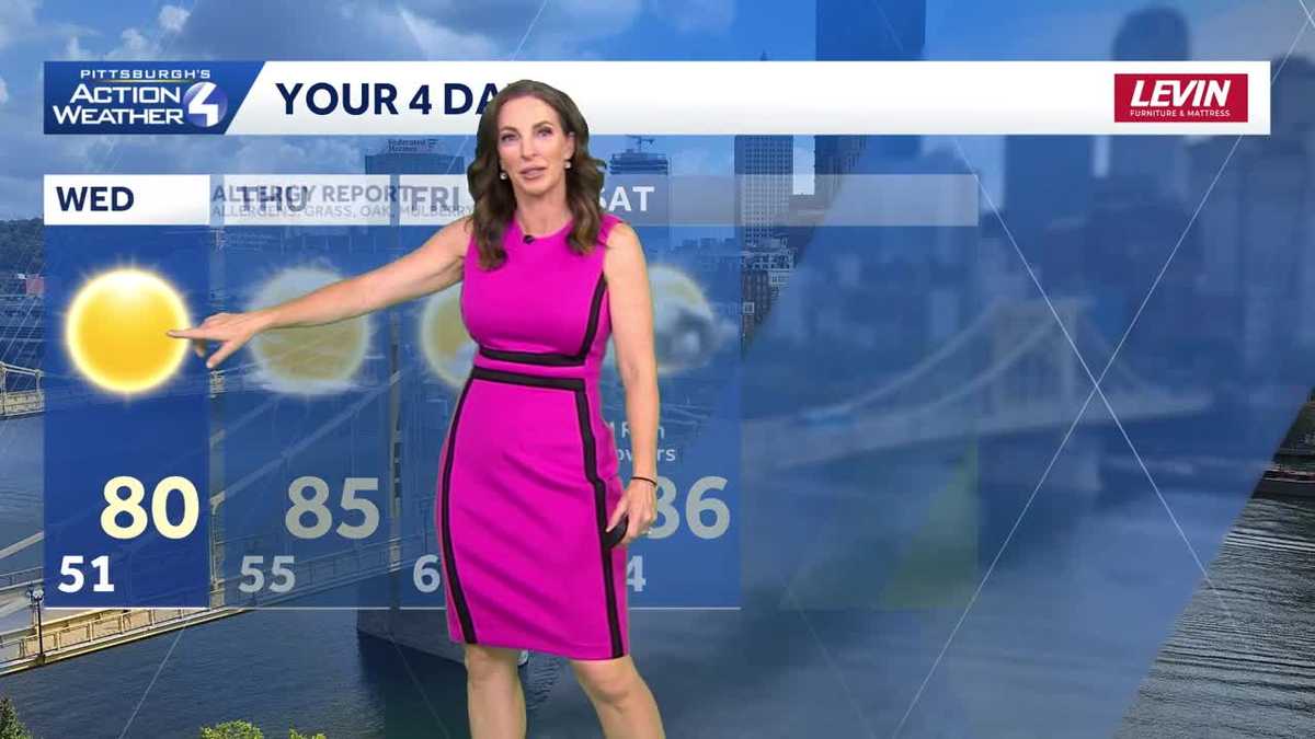
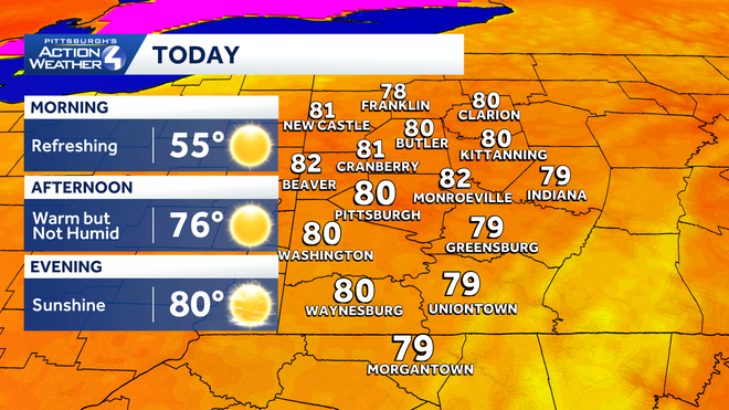
I SUSPECT THAT SON HAS SOMETHING TO DO WITH THAT. ASHLEY. YEAH, AND IT’S GOING TO BE SOMEWHERE ALL DAY LONG FOR SURE. BUT WE ARE EXPECTING TEMPERATURES TO START TO WARM UP TODAY, LOW 80S, EXTENDING IN THE MID TO UPPER 80S AS WE FINISH OUT THIS WEEK. AND WE WILL HAVE LOTS OF SUNSHINE. RADAR IS QUIET AND YOU CAN SEE FAIR SKIES NOT ONLY DOWNTOWN PITTSBURGH, BUT ALSO OUR CAMERA HERE RIGHT IN WILKINSBURG ABOVE OUR STATION THIS MORNING. ALTHOUGH SUNNY, STILL A LITTLE CHILL TO THE AIR. IT’S ONE OF THOSE MORNINGS IN THE SUNGLASSES, THE HOODIE OR LIGHT JACKET TO KICK IT OFF. 50 RIGHT NOW IN PITTSBURGH, 44 AS YOU WAKE UP IN BUTLER AND NEW CASTLE. 52, MONROEVILLE 48 IN GREENSBURG, WASHINGTON, AT 45, AND WAYNESBURG WAKING UP AT 41. DAYTIME HIGHS WILL GET INTO THE UPPER 70S AND LOW 80S. YOU’LL HIT NEAR 81 IN BUTLER AND CRANBERRY BEAVER WILL BE NEAR 84 TODAY, 79 IN OIL CITY AND CLARION IN INDIANA, GETTING UP NEAR 80. NOW THOSE HIGHER ELEVATIONS EAST ALWAYS JUST A TAD COOLER BUT STILL VERY COMFORTABLE IN THE LOW TO MID 70S AT SEVEN SPRINGS AND SOMERSET. UNIONTOWN WILL BE NEAR 80. MORGANTOWN 81 AND WAYNESBURG UP TO 80. THAT’S THE CASE ALSO IN THE CITY OF PITTSBURGH, WHERE IN CANONSBURG YOU’LL JUMP UP NEAR 81. 81 IN GREENSBURG AND 82 FOR YOUR HIGH IN MONROEVILLE. SO VERY NICE FOR US. BUT WITH THIS NICE WEATHER DOES COME A HIGHER POLLEN COUNT. I DEFINITELY CAN FEEL IT WHEN I’M OUTSIDE. AS WE’RE SITTING IN THE MEDIUM TO HIGH RANGE TODAY, CONTINUING THROUGH THE WEEK INTO THE START OF THE WEEKEND. AS FOR SATURDAY WILL START OFF DRY WITH SOME SUNSHINE. NOW OUR TOP POLLENS OR TOP ALLERGENS. EXCUSE ME, ARE GRASS, OAK AND MULBERRY, BUT WE WILL HAVE RAIN COMING IN SATURDAY AND SUNDAY MAY UPGRADED TO IMPACT DAYS. WE’RE GOING TO WAIT FOR ONE MORE DAY TO SEE IF THIS TIMING HOLDS, BUT IT DOES LOOK A BIT MORE ON THE SOGGY SIDE STARTING SATURDAY EVENING INTO SUNDAY. HERE’S THE LATEST TIMING OF IT. START TO SEE A FEW SHOWERS NORTH AROUND LUNCHTIME, BUT A LOT OF THIS COMING IN AROUND 3:00, O’CLOCK. WIDESPREAD RAIN INTO SATURDAY EVENING, EXTENDING OVERNIGHT INTO SUNDAY WITH POCKETS OF HEAVY RAIN CLOSER TO MIDNIGHT EARLY SUNDAY MORNING. NOW WE’LL STILL HAVE SOME SHOWERS THROUGH THE DAY ON SUNDAY, BUT SLOWLY IT WILL START TO TAPER OFF AND WE ARE EXPECTING TO DRY OUT AS WE HEAD INTO THE START OF NEXT WEEK. AND WITH THIS FRONT MOVING IN DOESN’T KNOCK OUR TEMPERATURES DOWN TOO MUCH. NOW WE’LL DROP BACK DOWN INTO THE LOW 80S ON SUNDAY, STAYING IN THE LOW TO MID 80S AS WE GET INTO NEXT WEEK AND REMAINING DRY. SO AGAIN, SATURDAY AND SUNDAY MAYBE UPGRADED TO IMPACT DAYS AS WE HEAD INT
Western PA: Warm up kicks off today
The forecast remains dry until the weekend. Rain now looks to impact plans starting Saturday afternoon.

Updated: 7:48 AM EDT Jun 3, 2026
A string of sunny, summer-like days begins today. High temperatures will peak in the lower 80s with a touch more humidity. We are still watching rain chances over the weekend. The rain’s arrival time is the trickiest part of the forecast.Warming up through late-weekA speedy warm up is on tap today. After a refreshing morning, highs will peak around 80 degrees. Plenty of sunshine will rule the sky over Pittsburgh again.A stair climb warm up will continue through Friday. Highs in the mid to upper 80s will go along with more humidity. The warmth will linger into the start of the weekend.Weekend rain chancesIt is likely to be a busy weekend around western Pennsylvania with the Three Rivers Arts Festival, the Morgan Wallen concerts along with graduations and graduation parties. The best and driest part of the weekend will be the first half of Saturday. There are still timing questions about weekend rain and storm chances. One of the latest model runs speeds up the initial showers to late Saturday afternoon. There is agreement that Saturday night will be wetter. Rain could be steady at times through Sunday. Rain totals will be higher to the north, where showers will initial pop up.Warm and dry next weekThe rain will come to an end Monday as high pressure starts to nose back into the area. Temperatures will remain in the low to mid 80s throughout next week.TODAY: Warm with plenty of sun. High: 80°.TONIGHT: Clear and comfortable. Low: 55°.THURSDAY: Warmer and not too humid. Mostly sunny. High: 85°, low: 60°.FRIDAY: Partly cloudy and feeling like summer. High: 87°, low: 64°.SATURDAY: Dry morning, rain showers arrive during the afternoon or evening. High: 86°, low: 66°.
PITTSBURGH —
A string of sunny, summer-like days begins today. High temperatures will peak in the lower 80s with a touch more humidity. We are still watching rain chances over the weekend. The rain’s arrival time is the trickiest part of the forecast.
Warming up through late-week
A speedy warm up is on tap today. After a refreshing morning, highs will peak around 80 degrees. Plenty of sunshine will rule the sky over Pittsburgh again.
Hearst OwnedHearst
A warm up begins today with highs around 80 degrees.
A stair climb warm up will continue through Friday. Highs in the mid to upper 80s will go along with more humidity. The warmth will linger into the start of the weekend.
Weekend rain chances
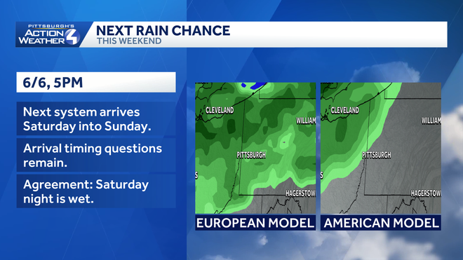
It is likely to be a busy weekend around western Pennsylvania with the Three Rivers Arts Festival, the Morgan Wallen concerts along with graduations and graduation parties. The best and driest part of the weekend will be the first half of Saturday. There are still timing questions about weekend rain and storm chances.
Hearst OwnedHearst
Arrival timing is an uncertain part of the weekend forecast.
One of the latest model runs speeds up the initial showers to late Saturday afternoon. There is agreement that Saturday night will be wetter. Rain could be steady at times through Sunday. Rain totals will be higher to the north, where showers will initial pop up.
Warm and dry next week
The rain will come to an end Monday as high pressure starts to nose back into the area. Temperatures will remain in the low to mid 80s throughout next week.
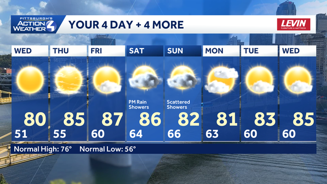
TODAY: Warm with plenty of sun. High: 80°.
TONIGHT: Clear and comfortable. Low: 55°.
THURSDAY: Warmer and not too humid. Mostly sunny. High: 85°, low: 60°.
FRIDAY: Partly cloudy and feeling like summer. High: 87°, low: 64°.
SATURDAY: Dry morning, rain showers arrive during the afternoon or evening. High: 86°, low: 66°.