
A WINDY HALLOWEEN IS HOW WE’LL PUT IT FOR THE DAY TODAY. THAT’S GOING TO BE THE MAIN STORY, WITH GUSTS REACHING POTENTIALLY TO 40 TO 45MPH. THAT’S WHY WE HAVE THIS IMPACT DAY. AS WE GET INTO THE AFTERNOON AND ALSO INTO THE REST OF THE EVENING, TODAY, A DRY AND SEASONABLE WEEKEND IS UP AHEAD. THEN AS WE GET INTO NEXT WEEK, RAIN CHANCES ARE ON THE HORIZON. BUT THOSE CHANCES REMAIN MINIMAL AS WE GET INTO THE WORK WEEK. STORM TEAM LIVE RADAR NETWORK RIGHT NOW SEEING SOME STRAY SHOWERS THAT ARE WORKING THEIR WAY IN FROM THE NORTHWEST, MAKING ITS WAY DOWN TOWARDS THE SOUTHEAST. EVEN EARLIER THIS MORNING, I WALKED INTO THE STATION, FELT A LITTLE SOME A LITTLE SPRITZ IN THE AIR BEFORE WALKING IN. BUT THAT’S THAT’S THE REASON WHY IS BECAUSE WE HAVE A BIT OF A MOISTURE FEED THAT’S COMING OFF OF THE GREAT LAKES, THAT THAT DEPARTING AREA OF LOW PRESSURE IS WHAT’S HELPING THAT MOISTURE FETCH. COMING IN OFF THE OFF THE LAKES. THAT’S WHY WE’RE SEEING SOME STRAY SHOWER CHANCES AS WE GET INTO THE DAY TODAY. SO THAT’S WHY WE HAVE THAT IN THE FOR TODAY’S FORECAST. THAT’S WHY WE HAVE THAT ACCOUNTED FOR 56 TO 60 DEGREES. BUT THE MAIN STORY ONCE AGAIN ARE THESE GUSTY WINDS. THAT’S WHY IT’S AN IMPACT DAY FOR GUSTS UP TO 45MPH WITH SUSTAINED WINDS BETWEEN 15 AND 25MPH OUT OF THE WEST NORTHWEST. FOR TONIGHT, THOUGH, DIMINISHING GUSTS MOSTLY CLEAR. WE STOP THE IMPACT AT MIDNIGHT FOR TONIGHT, 44 TO 48 DEGREES, BUT STILL A LITTLE BIT OF A BREEZE IN THE AIR. I’LL SAY A WEST NORTHWESTERLY BREEZE BETWEEN 10 AND 20MPH AND GUSTING AT 30MPH AT TIMES. PARTLY SUNNY, BREEZY AND SEASONABLE AS WE GET INTO THE FIRST HALF OF THE WEEKEND, 56 TO 60 DEGREES. SO I WOULD SAY A NICE START AS WE GET INTO OUR SATURDAY AS WELL AS OUR SUNDAY. BUT HERE’S THE CURRENT WIND SPEEDS RIGHT NOW. COMING IN OUT OF THE WEST, YOU CAN SEE 29 MILE PER HOUR BREEZE IN LANCASTER, 20 MILE PER HOUR BREEZE IN HARRISBURG. LOOK WHERE WE’RE HEADING TO AS WE GET INTO LATER IN THE AFTERNOON. STILL SUSTAINING IN THAT 10 TO 20 MILE PER HOUR RANGE. BUT LOOK WHAT HAPPENS AS WE GET TO HALLOWEEN FESTIVITIES. TRICK OR TREATING. THE WIND DOES DIE DOWN A BIT, BUT LOOK AT THIS STILL BREEZY OUT THERE. IF YOU HAVE ANY COSTUMES THAT HAVE ANY HATS ASSOCIATED WITH THEM, YOU MIGHT WANT TO MAKE SURE YOU KEEP THOSE. KEEP THEM SECURED THE GUSTS. STILL, YOU CAN SEE WITH THIS BAR GRAPH HERE THEY DO BEGIN TO RELAX BUT STILL GUSTY OUT THERE. STILL A LITTLE BIT BREEZY. THAT’S WHY WE’VE MADE IT AN IMPACT DAY FOR THE DAY. TODAY. WE DO HAVE A WIND ADVISORY IN EFFECT UNTIL MIDNIGHT TODAY. SO HERE ARE THE DETAILS. THE MAIN IMPACTS THAT I WANTED TO SHOW. YOU COULD SEE SOME ISOLATED POWER OUTAGES TODAY. SO MAKE SURE YOU SECURE ANY HALLOWEEN DECORATIONS AS WE GET INTO THE AFTERNOON AND THE EVENING. TEMPERATURES RIGHT NOW INTO THE 50S. AT THIS TIME, YOU CAN SEE JUST ANOTHER LOOK AT STORM TEAM LIVE RADAR NETWORK. JUST SEEING SOME OF THESE SHOWERS COMING IN FROM THE NORTHWEST. BUT AGAIN, VERY STRAY CHANCES AS WE GO INTO THE REST OF THE DAY. JUST WANTED TO ACCOUNT FOR THAT AS WE WENT INTO THE AFTERNOON. BUT WE WILL START TO SEE THOSE SKIES CLEAR AS WE GET INTO THE EVENING, AS WELL AS THE WINDS. RELAX AS WE HAVE HIGH PRESSURE BUILDING IN FROM THE SOUTH, YOU CAN SEE THE CENTER OF HIGH PRESSURE MOVING IN FROM THE SOUTHWEST. THAT WILL SETTLE IN OVERHEAD AND ALLOW PARTLY TO MOSTLY SUNNY CONDITIONS. AS WE GET INTO BOTH OUR SATURDAY AND ALSO OUR SUNDAY. AS WE GET INTO THE WEEKEND. SO DEFINITELY NICE WEEKEND FOR NEXT WEEK. WE ARE LOOKING AT SEASONABLE CONDITIONS PERSISTING ALONG WITH PLEASANT WEATHER FOR YOUR MONDAY AND TUESDAY. THE NEXT CHANCES FOR RAIN FOLKS WILL BE GOING INTO THURSDAY AND ALSO THE NEXT WEEKEND, BUT T
IMPACT: Blustery Halloween, gusts to 45 mph across south-central Pennsylvania
Highs will reach the upper 50s today, but the breeze will make it feel cooler.

Updated: 12:34 PM EDT Oct 31, 2025
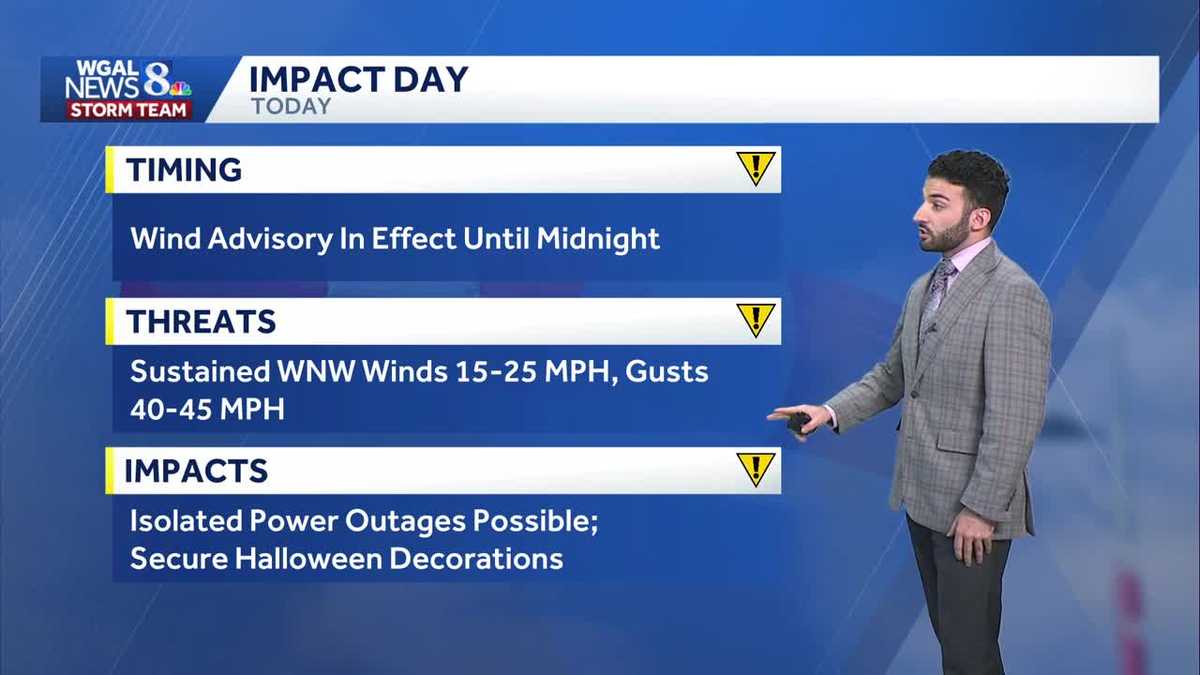
IMPACT: A Wind Advisory is in effect from 8 a.m. Friday until 12 a.m. Saturday. Wind gusts could reach 40-45 mph.As low-pressure lifts into New England, look mostly cloudy skies and a stray shower northwest this morning. We’ll see gradual clearing this afternoon, and mainly clear skies this evening. The bigger story is the wind. Expect sustained WNW winds 15-25 mph, with gusts to 40-45 mph. The prolonged duration of gusty winds may lead to isolated power outages. Be sure to secure your Halloween decorations!For trick-or-treaters, expect dry conditions under mostly clear skies. Winds will be blustery, but not as high as earlier in the day. Gusts will range from 30-35 mph between 6-8 p.m., and temperatures will hover in the low 50s, but it will feel like the upper 40s.Tonight, lows will fall to mid-40s under mostly clear skies. It will remain breezy, with gusts to 30 mph.Saturday will feature partly sunny skies, a 10-20 mph breeze, and highs in the upper 50s. As high pressure builds east Sunday, winds will be calmer. Look for partly to mostly sunny skies, with highs near 60.Next week, temperatures will remain around average, near 60 degrees. It will be mainly dry next week, with the exception of a shower late Monday and a few showers Thursday. Slightly better rain chances arrive late Saturday into Sunday.Have a great Friday!~ Ryan
IMPACT: A Wind Advisory is in effect from 8 a.m. Friday until 12 a.m. Saturday. Wind gusts could reach 40-45 mph.
As low-pressure lifts into New England, look mostly cloudy skies and a stray shower northwest this morning. We’ll see gradual clearing this afternoon, and mainly clear skies this evening. The bigger story is the wind. Expect sustained WNW winds 15-25 mph, with gusts to 40-45 mph. The prolonged duration of gusty winds may lead to isolated power outages. Be sure to secure your Halloween decorations!
For trick-or-treaters, expect dry conditions under mostly clear skies. Winds will be blustery, but not as high as earlier in the day. Gusts will range from 30-35 mph between 6-8 p.m., and temperatures will hover in the low 50s, but it will feel like the upper 40s.
Tonight, lows will fall to mid-40s under mostly clear skies. It will remain breezy, with gusts to 30 mph.
Saturday will feature partly sunny skies, a 10-20 mph breeze, and highs in the upper 50s. As high pressure builds east Sunday, winds will be calmer. Look for partly to mostly sunny skies, with highs near 60.
Next week, temperatures will remain around average, near 60 degrees. It will be mainly dry next week, with the exception of a shower late Monday and a few showers Thursday. Slightly better rain chances arrive late Saturday into Sunday.
Have a great Friday!
~ Ryan