
Pittsburgh: Warmer and more humid, Impact Day Saturday
Rain and storms arrive in the afternoon and evening Saturday.
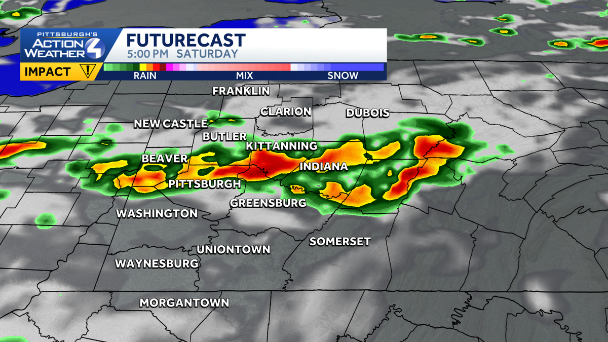
THOSE STORMS, RIGHT? YEAH, THE FIRST HALF JUST SHOWERS. IT’S REALLY THE SECOND HALF OF SATURDAY THAT WE ARE WATCHING. THAT’S GOING TO BE WE’RE RUNNING INTO THE CHANCE OF SEEING RAIN AND THUNDERSTORMS AROUND THE AREA. THAT’S THE DAY WE’RE WATCHING. AND THAT IS ALSO OUR IMPACT DAY. FRIDAY THOUGH, LOOKS FINE. ANOTHER WARM DAY WITH AMPLE SUNSHINE. LOOKS GOOD FOR ALL THE GRADUATIONS TOMORROW. GRADUATION PARTIES ON SATURDAY MAY BE A DIFFERENT STORY, BUT IF YOU CAN, YOU JUST WANT TO SLIDE THOSE SUNDAY OUTSIDE OF AN ISOLATED SHOWER. THAT’S LIKELY EARLY IN THE DAY. IT’S GOING TO BE WARM AND MUGGY AS WE HEAD THROUGH YOUR SUNDAY, SO CLIMB TO 88 DEGREES TOMORROW. THAT WOULD MAKE THAT THE WARMEST DAY OF THIS STRETCH, 86 FOR US ON SATURDAY IMPACT DAY WITH RAIN AND STORMS IN THE AFTERNOON. AGAIN, THAT LEFTOVER SHOWER CHANCE ON SUNDAY. THEN WE KEEP THE HEAT AND HUMIDITY AROUND. WE’RE AT 86 ON MONDAY. WILL HOVER IN THE UPPER 80S. TUESDAY AND WEDNESDAY WILL INCREASE THE CLOUDS WEDNESDAY AND THURSDAY AS ANOTHER SYSTEM TRIES TO DROP IN MAY PRODUCE A COUPLE OF SHOWERS ACROSS THE AREA. WE’LL WATCH FOR RAIN CHANCES THERE, BUT WE STAY WARM NEXT FRIDAY EVEN. WE WILL AGAIN TRY AND FLIRT WITH 90 DEGREES, BUT CHECK OUT OUR LOWS. WE ARE 60 OR BETTER FOR THE NEXT WEEK, WHICH MEANS YOU WILL START FEELING THAT HUMIDITY AS WE HEAD THROUGH THE AFTERNOONS. SO LET’S TALK ABOUT THAT SATURDAY FOR YOU. WE’LL START THE CLOCK HERE AT 8:00 SATURDAY MORNING. A COUPLE OF SCATTERED SHOWERS WILL BE POSSIBLE ACROSS WESTERN PENNSYLVANIA. NOT A WASHOUT, OBVIOUSLY, BUT YOU’LL LIKELY DODGE SOME RAINDROPS EARLY. THOSE SHOULD CLEAR BY NOON. THEN AFTER 2:00, WE’LL WATCH NORTH OF THE CITY OF PITTSBURGH, AS WE’LL LIKELY SEE SCATTERED THUNDERSTORMS, PERHAPS EVEN A LINE OF SHOWERS OR STORMS TRYING TO DEVELOP AS A COLD FRONT DROPS IN THAT WILL DRIFT SOUTH AND EASTWARD. BY THE TIME WE GET TO 5:00, THOSE SHOWERS AND STORMS APPROACHING PITTSBURGH AND ALLEGHENY COUNTY SLIDING, CONTINUING OFF TO THE SOUTH AND EAST. BUT BY NOTICE EIGHT 9:00, THOSE SHOWERS AND STORMS ARE GONE. SO THIS IS A VERY SMALL WINDOW. BUT WHILE THOSE STORMS ARE HERE, THEY COULD PACK A PUNCH. AS WE HEAD INTO YOUR SUNDAY WILL START OFF WITH CLOUDS, PERHAPS SOME FOG, AND MAY HAVE TO DODGE A SHOWER EARLY ON YOUR SUNDAY. AND THEN WE’LL SEE IMPROVING CONDITIONS AS WE HEAD INTO THE AFTERNOON. SO EVERYBODY NORTH PRETTY MUCH 70 HAS A SLIGHT RISK. THAT’S LEVEL TWO OUT OF FIVE FROM THE STORM PREDICTION CENTER OF A STRONGER STORM. WIND, RAIN AND HAIL ARE THE PRIMARY CONCERNS. A TORNADO CANNOT BE RULED OUT, BUT IT IS LOW ON OUR THREAT RISK. IF YOU’RE MAKING PLANS FOR THE THREE RIVERS ARTS FESTIVAL, TOMORROW IS A GREAT DAY. WILL BE AT 88. WATCHING THAT STORM CHANCE ON SATURDAY, YOU MAY WANT TO EITHER TAKE THE RAIN GEAR, TRY AND DODG
Pittsburgh: Warmer and more humid, Impact Day Saturday
Rain and storms arrive in the afternoon and evening Saturday.

Updated: 4:33 PM EDT Jun 4, 2026
A string of sunny, summer-like days lasts through the week. We are still watching rain chances over the weekend. Expect scattered showers and thunderstorms for the second half of Saturday, prompting an Impact Day. Impact Day SaturdayIt is likely to be a busy weekend around western Pennsylvania with the Three Rivers Arts Festival, the Morgan Wallen concerts, Pittsburgh Pride events, along with graduations and graduation parties.Saturday will feature the chance for some scattered showers in the morning before the main action arrives after 2 p.m. Scattered storms to a line of storms likely develops along the I-80 corridor and moves south through the day. This line should be in Pittsburgh between after 5 p.m. and be exiting our area around 9 p.m. Strong winds, large hail, lightning, and heavy rain are all possible. A tornado cannot be ruled out. For the threat of stronger storms in the afternoon and evening, Saturday is an Impact Day.Rain showers look to now taper off early Sunday morning. Outside of an isolated shower, Sunday will be dry and humid. Warm and dry next weekHigh pressure starts to nose back into the area on Monday. Temperatures will remain in the mid to upper 80s throughout much of next week. We should be fairly dry but more humid next week.TONIGHT: Mainly clear. Low: 60°.FRIDAY: Partly cloudy and feeling like summer. High: 88°, low: 68°.SATURDAY: Impact Day: Rain showers and thunderstorms, primarily during the afternoon and evening. High: 86°, low: 66°.SUNDAY: Partly cloudy with an isolated shower or two. High: 84°, low: 62°.
PITTSBURGH —
A string of sunny, summer-like days lasts through the week. We are still watching rain chances over the weekend. Expect scattered showers and thunderstorms for the second half of Saturday, prompting an Impact Day.
Impact Day Saturday
It is likely to be a busy weekend around western Pennsylvania with the Three Rivers Arts Festival, the Morgan Wallen concerts, Pittsburgh Pride events, along with graduations and graduation parties.
Hearst Owned
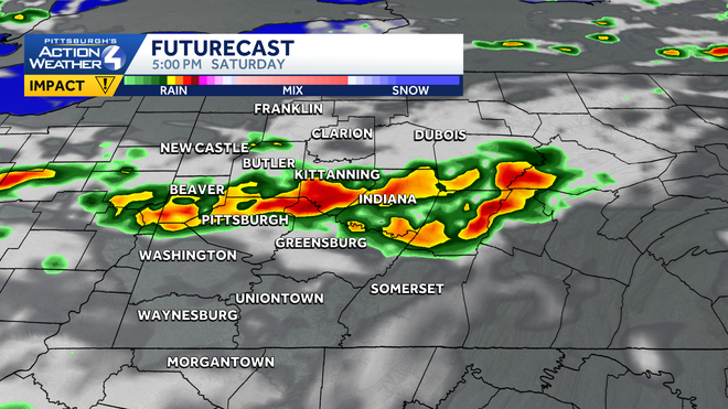
Storms arrive in the afternoon and evening for Western PA, reaching Pittsburgh likely in the 5 p.m. hour.
Saturday will feature the chance for some scattered showers in the morning before the main action arrives after 2 p.m. Scattered storms to a line of storms likely develops along the I-80 corridor and moves south through the day. This line should be in Pittsburgh between after 5 p.m. and be exiting our area around 9 p.m. Strong winds, large hail, lightning, and heavy rain are all possible. A tornado cannot be ruled out. For the threat of stronger storms in the afternoon and evening, Saturday is an Impact Day.
Rain showers look to now taper off early Sunday morning. Outside of an isolated shower, Sunday will be dry and humid.
Warm and dry next week
High pressure starts to nose back into the area on Monday. Temperatures will remain in the mid to upper 80s throughout much of next week. We should be fairly dry but more humid next week.
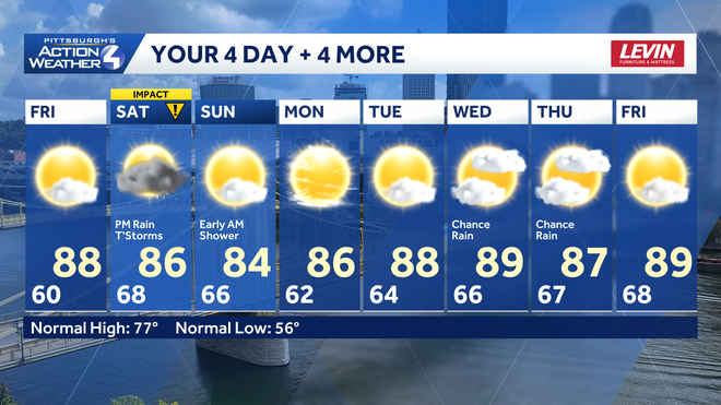
TONIGHT: Mainly clear. Low: 60°.
FRIDAY: Partly cloudy and feeling like summer. High: 88°, low: 68°.
SATURDAY: Impact Day: Rain showers and thunderstorms, primarily during the afternoon and evening. High: 86°, low: 66°.
SUNDAY: Partly cloudy with an isolated shower or two. High: 84°, low: 62°.