
Severe Thunderstorms Moving Out Of South Central Pennsylvania
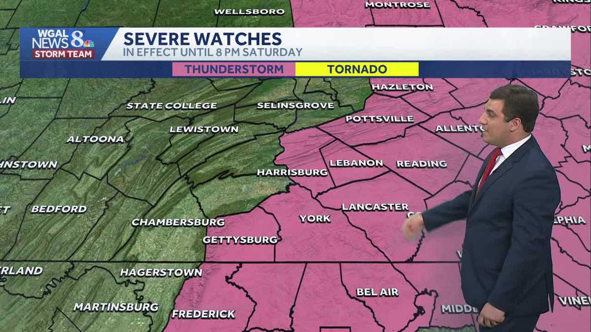
Severe thunderstorms are exiting the Susquehanna Valley after producing wind damage early Saturday evening.
CHRISTINE KAY PARTICIPATED IN THIS YEAR’S EVENT. LET’S BRING IN METEOROLOGIST MIKE SUSKO. MIKE, WE HAVE BEEN WATCHING THIS SEVERE WEATHER PUSH THROUGH CENTRAL PENNSYLVANIA ALL DAY. WHAT IS THAT TIMING LOOKING LIKE NOW? WELL, I HAVE SOME GOOD NEWS HERE, AJ BECAUSE THE STORMS ARE MOVING SO QUICKLY. BASICALLY, ONCE THIS LINE PUSHES OVER YOUR AREA, AFTER THAT INITIAL PUNCH, SO TO SPEAK, IT’S DONE. I MEAN, WE ALREADY HAVE SEVERE THUNDERSTORM WATCH NOW CANCELED FOR MIFFLIN, JUNIATA, PERRY, CUMBERLAND AND FRANKLIN COUNTIES. SO YOU’RE DONE IN THOSE AREAS FOR THE SEVERE THREAT. YOU CAN ENJOY THE REST OF THE EVENING. ADAMS COUNTY EVEN AND EVEN DAUPHIN COUNTY. TO BE HONEST WITH YOU, THINGS ARE WINDING DOWN. I WILL SAY WE STILL HAVE SOME STORMS, THOUGH, IN LEBANON, LANCASTER AND YORK COUNTY. IF YOU ARE IN BERKS AND ALSO IN CHESTER COUNTY THERE, YOU’RE GOING TO WANT TO MAKE SURE THAT YOU’RE STAYING WITH IT AS WELL HERE. SO WE’RE CONTINUING TO WATCH THE SEVERE THUNDERSTORM WATCH HERE. THIS WILL GO FOR ANOTHER HOUR OR SO AS WE GO THROUGH. HERE’S A LOOK AT THE RADAR, THOUGH. WE WILL CONTINUE TO BE WATCHING THESE STORMS AS WE PUSH ON THROUGH. YOU CAN SEE THAT LINE. IT LOOKS LIKE IT’S ACTUALLY EXITING OUR LEBANON AREA THERE RIGHT NOW. SO WE’LL ZOOM INTO LEBANON RIGHT NOW. THE HEAVY RAIN NOW PUSHING OUT OF YOUR AREA, BUT STILL DOWNPOURS IN LITITZ, MANHEIM AS WELL AS LANCASTER CITY. I CAN HEAR IT THERE ON THE ROOFTOP. MILLERSVILLE GETTING THE DOWNPOUR THERE RIGHT NOW. SAME THING IN LANDISBURG, EAST PETERSBURG THERE. COLUMBIA GETTING THE HEAVY RAIN. SAME THING IN PARADISE AND STRASBURG. YOU’RE GOING TO SEE THE HEAVY RAIN THERE VERY SHORTLY. THE SEVERE THUNDERSTORM WARNING FOR NORTH NORTHERN LANCASTER COUNTY. IT’S KIND OF MORE OF NORTHWEST IS MORE GOES TILL 630. BUT THE SEVERE THUNDERSTORM WARNING FOR EASTERN LANCASTER COUNTY AS WELL AS SOUTHERN LANCASTER COUNTY GOES TILL 715. SO THERE’S TWO OF THEM. IT KIND OF DEPENDS ON YOUR LOCATION. LET’S JUST SAY IF YOU ARE NORTH AND WEST OF LANCASTER, YOU’RE WARNING UNTIL 630. IF YOU’RE EAST AND SOUTH, IT GOES TILL 715. SO YOU’RE GOING TO WANT TO MAKE SURE YOU’RE STILL STAYING AWARE OF THIS LITTLE BRITAIN. HOLTWOOD QUARRYVILLE DELTA AREA. I KNOW YOU GUYS HAVE NOT SEEN ANYTHING YET. IT IS COMING WITHIN THE NEXT HALF HOUR OR SO. YOU CAN SEE THAT HEAVY RAIN THERE JUST OFF TO THE WEST. RED LINE AGAIN. GOT THAT HEAVY RAIN PUSHING THROUGH. IT’S MOVING OUT TOWARDS YOUR EAST AS WELL. YORK. YOU HAD THOSE DOWNPOURS AND HEAVY RAIN. IT IS NOW MOVING OUT THERE AS WELL. AND ALSO IN SOUTHERN YORK COUNTY NEAR SHREWSBURY GOT SOME DOWNPOURS. BUT AGAIN THIS IS ALL STARTING TO PUSH OFF TO THE EAST HERE AS WELL. IT’S NOT HIGH PRESSURE THERE WITH A COMFORTABLE CONDITIONS. UNFORTUNATELY IT WAS EARLIER, BUT WE ARE SEEING THOSE SYSTEMS NOW MOVE ON OUT. JUST A REMINDER FOR EVERYONE THOUGH WITH SEVERE THUNDERSTORM WATCH MEANS YOU WANT TO WATCH THE SKY. CONDITIONS ARE FAVORABLE FOR STORMS TO DEVELOP. SO THAT’S WHAT THE WATCH MEANS. IT’S THE WARNING THAT YOU WANT TO MAKE SURE YOU’RE TAKING ACTION. THAT MEANS YOU’RE ABOUT TO GET THE SEVERE THUNDERSTORM OR IT’S OCCURRING. SO THAT’S WHEN YOU ACTUALLY WANT TO TAKE SHELTER BY GOING INTO A STURDY BUILDING. LIKE AJ MENTIONED EARLIER. HERE’S A LOOK AT THE FORECAST FOR THE REST OF THE EVENING, THOUGH. WE ARE GOING TO SEE THOSE STORM CHANCES WIND DOWN OVER THE NEXT FEW HOURS. AND THEN TONIGHT, CLEARING SKIES LATE. IT’S MUGGY AND WARM. WE COULD SEE SOME PATCHY FOG THOUGH, BECAUSE OF ALL THE RAIN AND MOISTURE IN THE AIR. DON’T BE SURPRISED WITH THAT, ESPECIALLY IF WE ARE IN AN AREA THAT TYPICALLY GETS FOG. YOU MAY SEE SOME OF THAT TOMORROW. PARTLY SUNNY, BREEZY AND WARM. WE WILL SEE A DROP IN HUMIDITY AS WE GO THROUGH THE DAY TOMORROW, WITH TEMPERATURES AROUND 88 DEGREES THERE. THERE WE GO. THE CLICKERS BACK INTO WORKING. SO WE GOT FOR THE REST OF THE EVENING IS THAT THESE STORMS MOVE ON OUT AND MAYBE A FEW RESIDUAL SHOWERS WILL BE AROUND, BUT THEY’RE NOT GOING TO BE SEVERE. THE COLD FRONT THEN WILL MOVE ON THROUGH THE AREA. AS WE GO INTO YOUR FRIDAY. THAT’S GOING TO MAKE IT LESS HUMID AS WE GO THROUGH THE DAY ON YOUR SUNDAY, AND THEN MORE COMFORTABLE CONDITIONS FOR THE SECOND HALF OF THE WEEKEND. SO ORIGINALLY WE THOUGHT THAT SUNDAY WAS GOING TO BE THE DAY WITH THE STORMS. IT ACTUALLY IS NOW GOING TO BE THE NICER DAY HERE OVERALL TOMORROW. SO IF YOU HAVE ANY SUNDAY PLANS, YOU’RE GOOD TO GO. MONDAY’S COMFORTABLE TUESDAY WARM AND PLEASANT WITH A HIGH AROUND 86 DEGREES. THE REST OF THE TEN DAY FORECAST, WE DO SEE SOME STORM CHANCES RETURN TO THE SUSQUEHANNA VALLEY, AS WELL AS THOSE TEMPERATURES WARMING UP ONCE AGAIN TOWARDS THE UPPER 80S AND LOW 90S. AS WE HEAD TOWARDS FRIDAY AND THE FOLLOWING WEEKEND, WE WILL NEED TO WATCH SOME OF THESE STORMS HERE. CHANCES AS WE GO INTO THE MIDDLE AND END OF NEXT WEEK FOR POTENTIALLY SOME MORE WIND GUSTS. IT’S NOT UNCOMMON GUYS IN THE SUMMER FOR THIS TO HAPPEN. WHEN YOU GET HIGH TEMPERATURES NEAR 90 LIKE THIS, USUALLY THE STORMS, IF YOU GET THEM, WILL PRODUCE GUSTY WINDS. SO THAT’S ALWAYS SOMETHING TO BE MINDFUL OF. BUT I WILL TELL YOU THIS, AJ, I
Severe Thunderstorms Moving Out Of South Central Pennsylvania
Severe thunderstorms are exiting the Susquehanna Valley after producing wind damage early Saturday evening.

Updated: 7:14 PM EDT Jun 6, 2026
ALERT DAY: SEVERE THUNDERSTORM WATCH UNTIL 8 PMThe National Weather Service has issued a Severe Thunderstorm Watch for Dauphin, Lebanon, Lancaster, York, and Adams counties until 8 pm. this evening. Mifflin, Juniata, Perry, Cumberland, and Franklin counties were removed from the original severe thunderstorm watch.Strong thunderstorms are moving through Lebanon, York, and Lancaster counties and will exit the area by 7:30 pm. Scattered non-severe showers and thunderstorms may linger until about 11 p.m. REST OF THE WEEKEND:Once the storms clear out, the rest of the night will be warm & muggy with lows in the upper 60s under a clearing sky.Sunday will be mostly sunny, with highs once again in the upper 80s. Dew points will hover in the low 60s early, then fall later in the day as more comfortable air returns.NEXT WEEK:Plenty of sunshine kicks off the new week. Temperatures will be closer to average Monday, reaching the low 80s, and it will feel quite comfortable with low humidity. Warm, pleasant conditions are in store Tuesday, with highs near 84.The heat begins to build on Wednesday, with highs climbing into the upper 80s, and it will feel stickier as humidity rises. A stray shower or thunderstorm is possible too.By the end of the week, we’re back in hot and more humid conditions. Highs will reach the upper 80s to 90 degrees Thursday, with even hotter temperatures in the low 90s Friday through the weekend. Isolated rain chances are in the forecast Thursday and Friday. A higher chance of showers and thunderstorms arrives on Sunday.Have a great night!
ALERT DAY: SEVERE THUNDERSTORM WATCH UNTIL 8 PM
The National Weather Service has issued a Severe Thunderstorm Watch for Dauphin, Lebanon, Lancaster, York, and Adams counties until 8 pm. this evening. Mifflin, Juniata, Perry, Cumberland, and Franklin counties were removed from the original severe thunderstorm watch.
Strong thunderstorms are moving through Lebanon, York, and Lancaster counties and will exit the area by 7:30 pm. Scattered non-severe showers and thunderstorms may linger until about 11 p.m.
REST OF THE WEEKEND:
Once the storms clear out, the rest of the night will be warm & muggy with lows in the upper 60s under a clearing sky.
Sunday will be mostly sunny, with highs once again in the upper 80s. Dew points will hover in the low 60s early, then fall later in the day as more comfortable air returns.
NEXT WEEK:
Plenty of sunshine kicks off the new week. Temperatures will be closer to average Monday, reaching the low 80s, and it will feel quite comfortable with low humidity. Warm, pleasant conditions are in store Tuesday, with highs near 84.
The heat begins to build on Wednesday, with highs climbing into the upper 80s, and it will feel stickier as humidity rises. A stray shower or thunderstorm is possible too.
By the end of the week, we’re back in hot and more humid conditions. Highs will reach the upper 80s to 90 degrees Thursday, with even hotter temperatures in the low 90s Friday through the weekend. Isolated rain chances are in the forecast Thursday and Friday. A higher chance of showers and thunderstorms arrives on Sunday.
Have a great night!