
Warm & Sticky Sunday; Comfortable Start To Work Week In South Central Pennsylvania
Highs on Sunday will reach the upper 80s across the Susquehanna Valley.
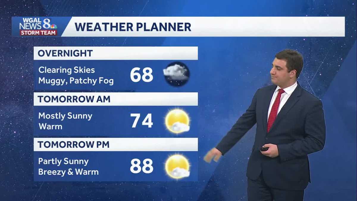
OUR NEWS DIRECTOR, CHRISTINE KAY. THEY BOTH PARTICIPATED IN THIS YEAR’S EVENT. NOW, BEFORE THAT HAPPENED, ALL BEFORE THE RAIN AND STORMS THAT HAPPENED TODAY WHERE WE SAW SOME SIGNIFICANT DAMAGE OUT THERE TODAY. YEAH WE DID. WE GOT SEVERAL REPORTS HERE TO A DAY AFTER THE STORMS PUSHED ON THROUGH. IN FACT, WHAT YOU’RE SEEING HERE IS ALL THE STORM REPORTS AS THAT LINE CAME ON THROUGH HERE. YOU SEE HOW WE HAVE A BUNCH OF THEM ACROSS THE SUSQUEHANNA VALLEY, ACROSS THE REGION HERE AS WELL? IN FACT, A TOTAL OF 33 OR ROUGHLY 33 STORM REPORTS SO FAR FROM THE NATIONAL WEATHER SERVICE, JUST IN THE SUSQUEHANNA VALLEY OR IN OUR VIEWING AREA ALONE. WHEN WE WERE TO INCLUDE EVERYONE HERE THAT HAD STORM DAMAGE REPORTS ACROSS THE REGION, IT WOULD BE OVER 100. NOW, THE GOOD NEWS IS THAT STORM TEAM LIVE RADAR NETWORK AT THIS POINT IS GOING TO BE A LOT MORE QUIET. WE DO HAVE SOME SHOWERS AND STORMS THERE IN SOUTHERN FRANKLIN COUNTY. THEY ARE NOT SEVERE, BUT WE ARE SEEING THAT CELL THERE NEAR GREENCASTLE AND ALSO WAYNESBORO RIGHT NOW. AGAIN, NOT SEVERE, JUST A LEFTOVER SHOWER AND STORM AS SOME MOISTURE IS PUSHING IN FROM THE WEST HERE. THAT’S GOING TO BE MOVING MORE TO THE SOUTH AND EAST AS WE GO THROUGH THE NEXT COUPLE OF HOURS. SO JUST A LITTLE BIT MORE RAIN THERE IN SOUTHERN FRANKLIN COUNTY, MAYBE EXTREME SOUTHERN ADAMS COUNTY HERE. IF IT CAN HOLD ON JUST A LITTLE LONGER. BUT OTHERWISE WE WILL BE DONE. HERE’S A LOOK OUTSIDE LANCASTER. RIGHT NOW IT IS A LOT QUIETER THAN IT WAS EARLIER THIS EVENING OUT THERE. AS THOSE STORMS ROLLED ON THROUGH. WE’LL CONTINUE TO SEE THE CLEARING SKIES AS WE GO THROUGH THE EVENING HERE RIGHT NOW. 66 LANCASTER. AND WE’RE KIND OF SEEING SIMILAR TEMPERATURES ACROSS THE ENTIRE SUSQUEHANNA VALLEY WITH THAT AT THE MOMENT, WE’LL GO AROUND 68 FOR THOSE OVERNIGHT LOWS HERE ACROSS THE AREA WITH A CLEARING SKY. IT WILL BE MUGGY. THAT EXTRA MOISTURE IN THE AIR THAT COULD LEAD TO SOME PATCHY FOG, ESPECIALLY IF YOU ARE IN A FOG PRONE AREA. YOU MAY SEE SOME OF THAT OVERNIGHT TONIGHT INTO TOMORROW MORNING. TOMORROW MOSTLY SUNNY, 74 DEGREES. GETTING IN THE MORNING, GOING UP TO 88 IN THE AFTERNOON UNDER A MIX OF SUN AND CLOUDS. IT’S BREEZY AND WARM. THE OTHER THING TOO TOMORROW IS THAT HUMIDITY IS GOING TO DROP. YOU ACTUALLY SEE DROPPING THROUGHOUT THE DAY AS A COLD FRONT COMES THROUGH HERE. AS WE GO INTO THE AFTERNOON. I KNOW IT’S KIND OF WEIRD TO SAY COLD FRONTS 88 DEGREES. WHAT ARE YOU TALKING ABOUT? BUT YES, BELIEVE IT OR NOT, WE’RE ACTUALLY GOING HAVE A COLD FRONT COMING THROUGH TOMORROW HERE. AND HERE’S A LOOK AT IT ON PREDICTOR AS WE GO THROUGH TOMORROW MORNING. YOU CAN SEE IT’S STARTING TO MOVE IN FROM THE NORTH. AND THAT’S GOING TO BRING IN THE LESS HUMID AIR AS WE GO INTO YOUR SUNDAY. SO YOU’LL SEE THAT HUMIDITY DROPPING THROUGHOUT THE DAY ON TOMORROW, WHICH IS GOING TO LEAD TO SOME COMFORTABLE CONDITIONS AS WE GO INTO MONDAY. MONDAY IS GOING TO BE KIND OF WHAT WE HAD EARLIER IN THE WEEK. WE SAW TEMPERATURES RIGHT AROUND AVERAGE LOW 80S. BUT BECAUSE THE HUMIDITY IS NOT THERE, IT’S ACTUALLY GOING TO BE QUITE PLEASANT START TO THE WEEK AS WE HEAD INTO MONDAY AFTERNOON. AND YOU KNOW, EVEN TUESDAY GOING TO BE WARM AND PLEASANT, 86 DEGREES THERE FOR A HIGH. SO WE GET A LITTLE BIT COOLER MONDAY AND TUESDAY. FOR THOSE OF YOU WHO ARE NOT QUITE READY FOR THE 90S, YOU HAVE A COUPLE DAYS WITH THAT. BUT TOMORROW, GREAT DAY TO THE POOL. SAME THING MONDAY AND TUESDAY. AND EVEN AS WE GO INTO WEDNESDAY, I STILL THINK IT’S GOING TO BE PRETTY DECENT HERE. BUT WE DO SEE THE CHANCE OF RAIN BEGINNING TO RETURN TO THE TEN DAY FORECAST HERE. AS WE GO INTO YOUR WEDNESDAY. SO ENJOY SUNDAY, MONDAY AND TUESDAY GUYS, BECAUSE WE WILL BE SEEING THINGS CHANGE HERE AS WE HEAD TOWARDS YOUR WEDNESDAY FRAME TIME FRAME, THURSDAY AND FRIDAY. ALSO OFFERING A CHANCE FOR SOME SHOWERS AND THUNDERSTORMS, BUT ALSO WARMING UP ONCE AGAIN. GETTING BACK INTO THE 90S WITH THAT HUMIDITY. BY THE END OF THE WEEKEND, MAYBE A LITTLE BIT WARMER THAN THAT AS WELL FOR SOME OF US. AND YOU CAN SEE AS WE HEAD INTO NEXT WEEKEND,
Warm & Sticky Sunday; Comfortable Start To Work Week In South Central Pennsylvania
Highs on Sunday will reach the upper 80s across the Susquehanna Valley.

Updated: 11:22 PM EDT Jun 6, 2026
Good evening,Warm & muggy conditions with lows in the upper 60s overnight under a clearing sky. Some patchy fog is possible.Sunday will be mostly sunny, with highs once again in the upper 80s. Dew points will hover in the low 60s early, then fall later in the day as more comfortable air returns.Plenty of sunshine kicks off the new week. Temperatures will be closer to average Monday, reaching the low 80s, and it will feel quite comfortable with low humidity. Warm, pleasant conditions are in store Tuesday, with highs near 84.The heat begins to build on Wednesday, with highs climbing into the upper 80s, and it will feel stickier as humidity rises. A stray shower or thunderstorm is possible too.By the end of the week, we’re back in hot and more humid conditions. Highs will reach the upper 80s to 90 degrees Thursday, with even hotter temperatures in the low 90s Friday through the weekend. Isolated rain chances are in the forecast Thursday and Friday. A higher chance of showers and thunderstorms arrives on Sunday.Have a great night!
Good evening,
Warm & muggy conditions with lows in the upper 60s overnight under a clearing sky. Some patchy fog is possible.
Sunday will be mostly sunny, with highs once again in the upper 80s. Dew points will hover in the low 60s early, then fall later in the day as more comfortable air returns.
Plenty of sunshine kicks off the new week. Temperatures will be closer to average Monday, reaching the low 80s, and it will feel quite comfortable with low humidity. Warm, pleasant conditions are in store Tuesday, with highs near 84.
The heat begins to build on Wednesday, with highs climbing into the upper 80s, and it will feel stickier as humidity rises. A stray shower or thunderstorm is possible too.
By the end of the week, we’re back in hot and more humid conditions. Highs will reach the upper 80s to 90 degrees Thursday, with even hotter temperatures in the low 90s Friday through the weekend. Isolated rain chances are in the forecast Thursday and Friday. A higher chance of showers and thunderstorms arrives on Sunday.
Have a great night!