
Quiet & Pleasant Night; Storms, Heat, & Humidity Return For 2nd Half Of The Week In South Central Pennsylvania
High temperatures will increase from the mid 80s on Thursday to the low 90s by Thursday.
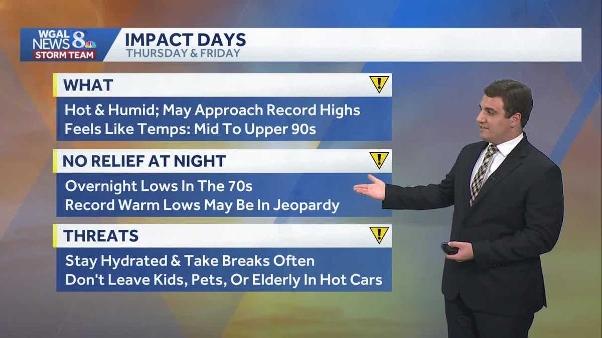
ARREST. NOW, ACCORDING TO A REPORT FROM THE MEDICAL EXAMINER, BOLLEA PREVIOUSLY HAD LEUKEMIA AND ATRIAL FIBRILLATION, AN IRREGULAR HEART RHYTHM, AND THE DEPARTMENT ULTIMATELY CLASSIFIED IT. MIND, ESPECIALLY DURING THE DAY THOUGH. MAKE SURE YOU STAY HYDRATED. TAKE BREAKS OFTEN AND PLEASE REMEMBER YOUR KIDS, PETS AND THE ELDERLY IN HOT CARS. IN AREAS WHERE THERE’S NO AIR CONDITIONING. BUT HERE’S A LOOK AT THE FORECAST HIGHS FOR THURSDAY AND FRIDAY. THURSDAY. I DON’T THINK WE’RE GOING TO BE HITTING THAT RECORD HIGH. IT’S A LITTLE TOO MUCH AROUND 96 DEGREES WILL BE DEPENDING ON HOW MUCH CLOUD COVER WE GET, THOUGH ON FRIDAY. IT’S GOING BE RIGHT AROUND 92 FROM 2017. WE’RE EXPECTING TO BE WITHIN A DEGREE OR AROUND THAT AS WE GO INTO IT. NOW I DO WANT TO REMIND YOU, AS YOU’RE WALKING YOUR DOGS TOWARDS THE END OF THE WEEK, ESPECIALLY, MAKE SURE THAT YOU’RE WALKING THEM IN THE GRASS BECAUSE AS THE TEMPERATURE RISES, YOU CAN SEE IT’S GOING TO GET REALLY WARM THERE ON THE PAVEMENT. IN FACT, IT ONLY NEEDS TO BE AT 87 DEGREES IN DIRECT SUNLIGHT FOR THAT PAVEMENT TO BE 100, 143 DEGREES. AND AT 125, THAT’S WHEN SKIN CAN START GETTING DAMAGED BY THE BY HOT SURFACES. SO PLEASE KEEP THAT IN MIND WITH YOUR PETS. AS WE GO THROUGH LATER PART OF THE WEEK. NOW, RIGHT NOW IT’S A LITTLE BIT ON THE COOLER SIDE, 75 IN HARRISBURG, 73 IN LANCASTER. IT’S 77 IN LEWISTOWN AND 79 IN GETTYSBURG. THE CLOUDS HAVE BEEN AROUND ALL DAY BECAUSE OF THAT. AIR OFF OF THE ATLANTIC IS KEEPING US COOL. WE ARE WATCHING OUR NEXT CHANCE FOR STORMS ON WEDNESDAY. SO THESE STORMS HERE, THEY’RE GOING TO START MOVING INTO OHIO AND WESTERN PENNSYLVANIA TOMORROW AND TOMORROW NIGHT AND WEDNESDAY. THAT’S WHEN THEY MOVE INTO THE SUSQUEHANNA VALLEY. SO WHEN WE LOOK AT YOUR WEATHER PLANNER FOR THIS EVENING, MOSTLY CLOUDY. IT’S PLEASANT, PARTLY CLOUDY AND COOLER THOUGH. TONIGHT WE GO BACK TO AROUND 58 DEGREES FOR THAT LOW. TOMORROW WE’RE LOOKING AT TEMPERATURES GETTING RIGHT AROUND THE MID 80S THERE AS WE GO THROUGHOUT YOUR TUESDAY. BUT I DO THINK YOU SEE SOME CLOUDS TOMORROW AS WELL. NOTICE WINDS COMING OUT OF THE SOUTH. THAT HELPS WARM THINGS UP A LITTLE BIT. BUT WE STILL GOT THAT MIX OF SUN AND CLOUDS AS WE GO THROUGH YOUR TUESDAY. AS WE GO INTO TUESDAY NIGHT, IT’S MAINLY DRY TO START, BUT BY THE TIME WE’RE WAKING UP ON WEDNESDAY MORNING, I DO EXPECT THERE TO BE SOME SCATTERED SHOWERS AROUND. THESE ARE NOT GOING TO NECESSARILY BE ANYTHING ON THE SEVERE SIDE. THERE’S NO INSTABILITY OR FUEL FOR THESE STORMS IN THE MORNING. IN THE AFTERNOON, THAT’S A DIFFERENT STORY. AND WE GET SOME FUEL TO FIRE UP HERE IN THE AFTERNOON AND EVENING ON WEDNESDAY. SO STORMS THAT ARE FORMING RIGHT NOW AROUND 8:00 ON WEDNESDAY HERE IN THE SUSQUEHANNA VALLEY, EVEN OUT TO THE WEST, WE WILL NEED TO WATCH FOR MAYBE SOME GUSTY WINDS AS IT PULLS ON THROUGH. AND THEN WE ALSO SAW AGAIN THOSE HOT TEMPERATURES AS WE GO INTO YOUR THURSDAY. SO WE’RE GOING TO CONTINUE THAT WARMING TREND TOWARDS THE 90S AS WE HEAD INTO THURSDAY AND FRIDAY. THAT IS WHY, AGAIN, THOSE DAYS ARE IMPACT DAYS. WE ALSO HAVE TO WATCH FOR SOME THUNDERSTORMS, WHICH COULD PRODUCE SOME GUSTY WINDS WITH IT. THAT IS NOT UNCOMMON WHEN YOU GET INTO THE LOW 90S, ESPECIALLY THIS TIME OF YEAR, USUALLY COMES WITH SOME GUSTY WINDS WITH THUNDERSTORMS. SO THAT’S SOMETHING WE’LL HAVE TO MONITOR ON SATURDAY. HOT, STICKY, BUT DOES LOOK DRY. AND THEN AS WE GO INTO SUNDAY GUYS, ANOTHER CHANCE FOR MAYBE SOME ISOLATED STORMS BEFORE WE SEE THINGS COOLER AS WE GO INTO NEXT WEEK. BUT YEAH, IT’S GOING TO BE A REAL HOT INTO THE WEEK HERE. HOPEFULLY THOSE STORMS HOLD OFF BECAUSE I CAN TELL YOU WHAT, IF THEY DO, IT’S GOING TO BE GREAT WEATHER. OH YES. ABSOLUTELY. YEAH. SOME BEACH TRIPS TOO. OH YEAH. I THINK A LOT OF FOLKS ARE GOING TO BE GOING TO THE BEACH ON SATURDAY HERE. SO SOMETHING TO KEEP IN MIND FOR THE TRACK F
Quiet & Pleasant Night; Storms, Heat, & Humidity Return For 2nd Half Of The Week In South Central Pennsylvania
High temperatures will increase from the mid 80s on Thursday to the low 90s by Thursday.

Updated: 4:53 PM EDT Jun 8, 2026
Good afternoon,The clouds remain across the Susquehanna Valley this evening with some breaks in between. Tonight, overnight lows will drop to the upper 50s under a partly cloudy sky. The comfortable conditions continue Tuesday, with plenty of sunshine early in the day followed by increasing clouds. Afternoon highs around 84 degrees.The heat begins to build on Wednesday, as highs climb to the upper 80s, and it will feel stickier as humidity levels rise. Shower and storm chances return too.By the end of the week, hot and increasingly humid conditions will return. Highs are expected to reach the low 90s on Thursday and Friday. Daily records may be reached in some areas. Thursday will be the hottest day of the week. The record high is 96° set in 1911.The record for Friday is 92°, set in 2017. As the heat and humidity build, the chance for afternoon and evening thunderstorms will increase both days, with the greater threat appearing to be on Friday late afternoon and evening.Temperatures will remain hot through the weekend, with highs hovering around 90 degrees on Saturday and Sunday. Skies will be partly sunny, and a few showers and thunderstorms will be possible on Sunday.Next week features more opportunities for showers and storms, while temperatures ease back into the 80s.Have a great night!
Good afternoon,
The clouds remain across the Susquehanna Valley this evening with some breaks in between. Tonight, overnight lows will drop to the upper 50s under a partly cloudy sky.
The comfortable conditions continue Tuesday, with plenty of sunshine early in the day followed by increasing clouds. Afternoon highs around 84 degrees.
The heat begins to build on Wednesday, as highs climb to the upper 80s, and it will feel stickier as humidity levels rise. Shower and storm chances return too.
By the end of the week, hot and increasingly humid conditions will return. Highs are expected to reach the low 90s on Thursday and Friday. Daily records may be reached in some areas. Thursday will be the hottest day of the week. The record high is 96° set in 1911.
The record for Friday is 92°, set in 2017. As the heat and humidity build, the chance for afternoon and evening thunderstorms will increase both days, with the greater threat appearing to be on Friday late afternoon and evening.
Temperatures will remain hot through the weekend, with highs hovering around 90 degrees on Saturday and Sunday. Skies will be partly sunny, and a few showers and thunderstorms will be possible on Sunday.
Next week features more opportunities for showers and storms, while temperatures ease back into the 80s.
Have a great night!