
Western PA weather turns stormy again with heavy rain, hail possible
Thursday will be the hottest day of the week; Friday the stormiest.
HE IS IN CRITICAL CONDITION RIGHT NOW. A COUPLE OF KEY TAKEAWAYS FOR THESE THREE DAYS IN A ROW. WHEN IT COMES TO OUR STORM CHANCES, MOST OF TODAY’S ACTIVITY HAPPENS BEFORE NOON WITH A LIMITED SEVERE THREAT, AND WE SHIFT OUR FOCUS PRIMARILY EAST OF PITTSBURGH TOMORROW. IT’S ALSO GOING TO BE PLENTY STEAMY, AND FRIDAY NOW HAS THE POTENTIAL TO BE UPGRADED TO A SEVERE WEATHER ALERT DAY, WITH BETTER COVERAGE OF STORMS, A LITTLE MORE INTENSITY BEHIND THOSE STORMS, TOO. WE’LL TALK ABOUT THOSE CHANGES HERE IN JUST A SECOND. BUT ALREADY THE RADAR IS UP AND WORKING WITH A FEW BRIEF DOWNPOURS SCATTERED ACROSS BEAVER COUNTY, EVEN SPREADING UP TOWARDS MORAINE STATE PARK AND LILLIAN OPEL. SOME ACTION SPRINKLED ACROSS WESTMORELAND COUNTY, TOO, WHICH IS GENERALLY LIGHT AT THIS POINT, ALMOST LOOKS LIKE THE RADAR SHOWING UP WITH SOME POLKA DOTS SOUTH OF WASHINGTON, WORKING ALONG I-70. A RAINY RIDE THERE IS. THAT CELL WILL CONTINUE TO TRACK EASTWARD AS WE GO THROUGH THE START OF THE DAY. AND THEN THAT LONE THUNDERSTORM JUST OUTSIDE OF EAST LIVERPOOL ALSO COULD BE CLIPPING PARTS OF BEAVER AND ALLEGHENY COUNTY. AS WE GO THROUGH THE START OF THIS IMPACT DAY. SO THE COVERAGE STARTING TO PICK UP HERE AS WE’RE WORKING THROUGH THE VERY EARLY STAGE OF YOUR MORNING COMMUTE, WE WON’T BE RID OF THINGS UNTIL ABOUT NOONTIME TODAY. THOSE STORMS COULD HAVE A LITTLE BIT MORE POP NECESSARILY WITH SEVERE WEATHER, BUT MORE SOME HEAVY RAIN, VIVID LIGHTNING, AND ALSO SOME STRONGER WIND GUSTS. WE GET YOU SET TOWARDS ABOUT TEN, 11:00 THIS MORNING. A LOT OF THAT IS MOVING EAST AS WE HIT THE NOON HOUR. CHECK THIS OUT, SUNSHINE. BY THE SECOND HALF OF THE DAY AS WE WILL CUT BACK OUR SHOWER AND STORM CHANCES THROUGH THE AFTERNOON AND EVENING HOURS. BUT A FEW MORE CLUSTERS COULD BE FIRING AS WE GET YOU SET FOR AFTER MIDNIGHT. FUTURE CAST BEEN HAVING A HARD TIME HANDLING THAT ROUND, SO WE’LL BE PAYING CLOSE ATTENTION TO THAT THROUGHOUT THE DAY. SECOND IMPACT DAY IN A ROW TOMORROW WE’LL SEE SOME ACTIVITY CUTTING ACROSS THE REGION AS EARLY AS LATE MORNING, EXTENDING THROUGH THE EARLY AFTERNOON. BUT AS YOU SAW A LOT OF WHAT’S BEEN ON FUTURECAST IS GOING TO BE DURING THE SECOND HALF OF THE DAY, WE ARE GOING TO TONE DOWN OUR FLASH FLOODING RISK AS WE HAVEN’T SEEN MUCH HEAVY RAIN JUST YET, BUT OF COURSE, PLENTY OF HUMIDITY IN THE AIR AND THAT WILL FUEL UP THOSE FEELS LIKE TEMPERATURES TOMORROW THOUGH, WELL INTO THE 90S. JUST ANOTHER COMPONENT OF OUR IMPACT DAY. AND THEN FRIDAY AGAIN, THE DAY THAT WE ARE PAYING ATTENTION TO POTENTIAL TO BE UPGRADED TO AN ALERT DAY, COLD FRONT IS GOING TO BE SLICING THROUGH THE AREA. YOU COULD SEE A BETTER COVERAGE OF STORMS DURING THE AFTERNOON. THAT WOULD BE AN AREA WIDE THREAT FOR STILL MORE STRONG WINDS, HEAVY RAIN. SO WE GET ONE MORE MODEL RUN IN BEFORE WE MAKE A DECISION ABOUT FRIDAY. AS WE LOOK AHEAD TO THE UPCOMING WEEKEND, OF COURSE, THE ARTS FESTIVAL WILL BE OPENING BACK UP. PLENTY OF TIME TO ENJOY THAT ON SATURDAY. MOST OF SUNDAY WILL BE DRY TOO, BEFORE WE SLIDE BACK INTO THE 70S NEXT WEEK IN THE 70S, WHERE WE START VISIBILITY BEING IMPACTED NOW AT THE AIRPORT ABOUT SIX MILES, AND YOU CAN SEE THAT THICK AIR OVER DOWNTOWN TEMPERATURES CLIMBING INTO THE MID 80S TODAY. WE WILL KEEP IT STEAMY DURING THESE IMPACT DAYS. BUT AGAIN, WE GE
Western PA weather turns stormy again with heavy rain, hail possible
Thursday will be the hottest day of the week; Friday the stormiest.

Updated: 7:34 AM EDT Jun 10, 2026
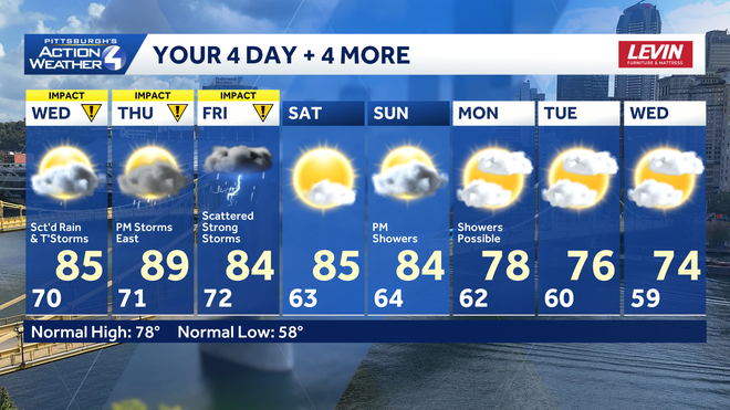
Storm chances are on the rise with three Impact Days in a row. Steamy conditions are building too with feels like temperatures in the mid 90s Thursday. Friday will be the stormiest day, and has the potential to be upgraded to an Alert Day.Three Impact Days for growing storm chancesThunderstorms will be capable of producing gusty winds and hail across the three Impact Days. The flash flooding risk is becoming more limited, despite the heavy rain that any storm will carry.We are tracking scattered rain with spotty storms before noon today. Given the time of day, the severe potential will be limited. Areas of heavy rain will be possible for some of our morning commutes.The focus of Thursday’s thunderstorms is leaning east of Pittsburgh during the early afternoon. Friday looks to see the best coverage of storms and the potential for more severe weather as the cold front passes. There is the best potential to upgrade to an Alert Day.Steamy afternoonsA humid feeling will be with us all day long. Feels like temperatures will spike in the mid to upper 90s on Thursday, another part of the Impact Day.Quieter, more seasonal start to the weekendThe weather will calm down over the weekend. Highs will be toned down to the lower 80s and humidity levels will be more tolerable. We are monitoring the potential for more showers for late Sunday into next Monday with a cold front. More seasonal temperatures will follow next week.TODAY – Impact Day: Scattered rain with a storm before noon. Some afternoon sun. High: 85°.TONIGHT: Isolated showers. Low: 71°.THURSDAY – Impact Day: Hot and humid with feels like temperatures in the mid 90s. Afternoon storms, especially east. High: 89°, low: 72°.FRIDAY – Impact Day: Scattered strong thunderstorms. High: 84°, low: 63°.SATURDAY: Staying warm as sunshine returns. High: 85°, low: 64°.
Storm chances are on the rise with three Impact Days in a row. Steamy conditions are building too with feels like temperatures in the mid 90s Thursday. Friday will be the stormiest day, and has the potential to be upgraded to an Alert Day.
Three Impact Days for growing storm chances
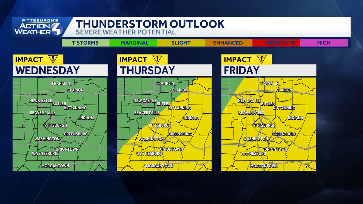
Thunderstorms will be capable of producing gusty winds and hail across the three Impact Days. The flash flooding risk is becoming more limited, despite the heavy rain that any storm will carry.
Hearst OwnedHearst
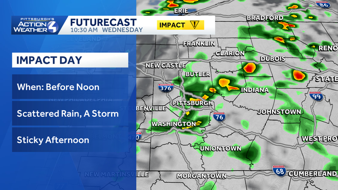
Scattered rain with embedded rumbles of thunder will cross western PA before noon on this Impact Day.
We are tracking scattered rain with spotty storms before noon today. Given the time of day, the severe potential will be limited. Areas of heavy rain will be possible for some of our morning commutes.
Hearst OwnedHearst
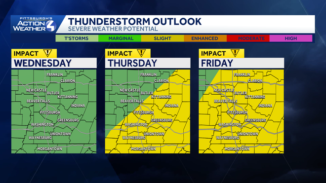
Friday will feature the best coverage of thunderstorms.
The focus of Thursday’s thunderstorms is leaning east of Pittsburgh during the early afternoon. Friday looks to see the best coverage of storms and the potential for more severe weather as the cold front passes. There is the best potential to upgrade to an Alert Day.
Steamy afternoons
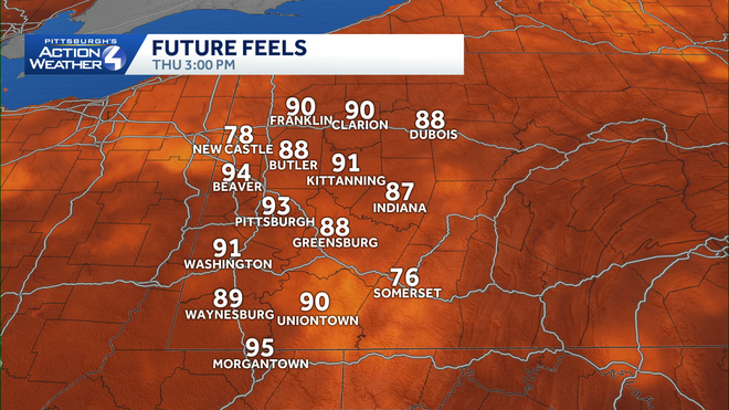
A humid feeling will be with us all day long. Feels like temperatures will spike in the mid to upper 90s on Thursday, another part of the Impact Day.
Hearst OwnedHearst
A steamy Thursday afternoon with feels like temperatures well into the 90s.
Quieter, more seasonal start to the weekend
The weather will calm down over the weekend. Highs will be toned down to the lower 80s and humidity levels will be more tolerable. We are monitoring the potential for more showers for late Sunday into next Monday with a cold front. More seasonal temperatures will follow next week.
Hearst OwnedHearst
Rain will hold off until late Sunday for western PA. Temperatures will turn more seasonal next week.
TODAY – Impact Day: Scattered rain with a storm before noon. Some afternoon sun. High: 85°.
TONIGHT: Isolated showers. Low: 71°.
THURSDAY – Impact Day: Hot and humid with feels like temperatures in the mid 90s. Afternoon storms, especially east. High: 89°, low: 72°.
FRIDAY – Impact Day: Scattered strong thunderstorms. High: 84°, low: 63°.
SATURDAY: Staying warm as sunshine returns. High: 85°, low: 64°.