
Pittsburgh: Sun today, Impact Day Sunday
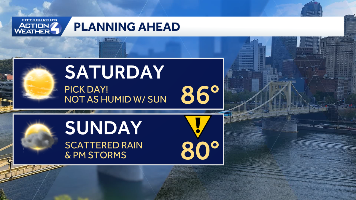
Warm but not as humid with sunshine for the pick day of the weekend.
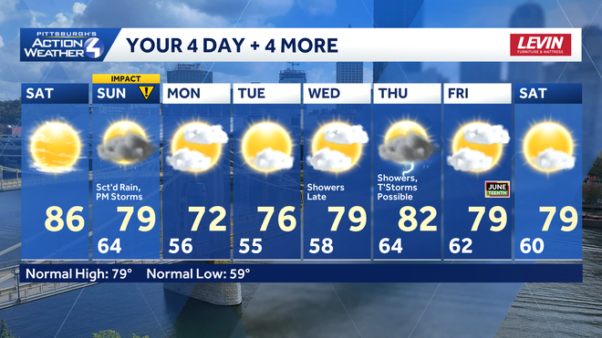
HANDLE PEOPLE MAKING FUN OF YOU, BRING AN UMBRELLA. AND NOW CHECKING IN WITH METEOROLOGIST JILL SZWED. ARE WE GOING TO NEED THAT UMBRELLA IN THOSE WATER BOTTLES TODAY? YEAH, IT’S A LITTLE TOASTY THIS AFTERNOON. PLENTY OF SUNSHINE TOO. SO ESPECIALLY IF YOU’RE DOWN IN THE CITY, MAYBE A LITTLE BIT WARMER. AND TOMORROW THE RAIN GEAR WILL COME IN MORE HANDY AS WE ARE TRACKING THE POTENTIAL FOR SHOWERS AND THUNDERSTORMS ON AN IMPACT DAY. BUT FIRST, TODAY IS THE PICK OF THE WEEKEND DEALING WITH SOME AREAS OF PATCHY FOG THIS MORNING. IT’S REALLY NICE. OUTSIDE HUMIDITY HAS BEEN CUT BACK, SO EVEN THOUGH TEMPERATURES WILL BE SURGING WELL INTO THE 80S TODAY, IT WILL BE MANAGEABLE FOR YOU. AND AS WE GO INTO THE EVENING, TEMPERATURES WILL SLOWLY BACK OFF THROUGH THE 80S, EVENTUALLY BACK INTO THE 70S AND 60S BY DAYBREAK TOMORROW AGAIN TOMORROW, OUR NEXT IMPACT DAY. I KNOW IT’S BEEN A LONG STRETCH OF UNSETTLED WEATHER ACROSS THE AREA. NOW, A COUPLE COMPLICATING FACTORS. IF WE HAPPEN TO SEE MORE CLOUDS AND EVEN A FEW SHOWERS EARLY IN THE DAY TOMORROW, THAT WOULD CUT BACK ON OUR SEVERE POTENTIAL. BUT WE ARE STILL WAITING ON A COLD FRONT THROUGH THE AFTERNOON THAT WILL BRING ADDITIONAL SCATTERED HEAVY RAIN, POSSIBLY SOME STRONGER WIND GUSTS. AGAIN, HOW STRONG THOSE STORMS GET WILL ALL DEPEND ON WHAT HAPPENS DURING THE FIRST HALF OF THE DAY TOMORROW. BEHIND THAT SYSTEM, WE GET A MORE ENJOYABLE STRETCH WITH EVEN LOWER HUMIDITY AND COOLER TEMPERATURES NEXT WEEK. BUT LET’S FOCUS IN ON THAT IMPACT DAY FOR TOMORROW. STRONG WINDS WOULD LEAD THE WAY. THAT AREA WIDE SCATTERED STRONG TO SEVERE STORM THREAT. ALSO, TONS OF LIGHTNING HAIL MORE THAN LIKELY AT OR JUST BELOW SEVERE LIMITS. SO THAT’S QUARTER SIZE OR SMALLER. WHILE WE WILL BE DEALING WITH HEAVY RAIN NOT EXPECTING MUCH FLOODING AS THESE STORMS WILL BE MOVING ALONG AT A DECENT PACE TOMORROW AFTERNOON TO YOUR FOUR DAY FORECAST. BEFORE WE GET THERE, ENJOY TODAY. AGAIN, A LITTLE COOL THIS MORNING. TEMPERATURES WILL BE REALLY WARMING UP FAST. IF YOU’RE MAKING YOUR WAY TO ARTS LANDING FOR ONE OF THE FINAL DAYS OF THE THREE RIVERS ARTS FESTIVAL, A FEW MORE CLOUDS WILL START TO DRIFT IN JUST AS THINGS WRAP UP AROUND 9:00 TONIGHT. AGAIN TOMORROW, OUR IMPACT DAY, WE’LL TAKE A CLOSER LOOK AT THE TIMELINE HERE IN JUST A SECOND. THEN YOU’LL NOTICE TEMPERATURES FALLING BACK INTO THE 70S, MORNING LOWS DOWN INTO THE 50S EARLY NEXT WEEK. WE WILL KEEP THE RAIN AWAY UNTIL PROBABLY LATE WEDNESDAY. THURSDAY HAS A POTENTIAL TO PRODUCE NOT ONLY MORE SHOWERS, BUT EVEN SOME THUNDERSTORMS. BUT THINGS WILL BE DRY AND COMFORTABLE ONCE AGAIN BY THE TIME WE GET TO JUNETEENTH NEXT FRIDAY. LET’S TAKE A CLOSER LOOK AT TOMORROW’S IMPACT DAY. SOME CLOUDS STARTING TO DRIFT IN AS WE GO THROUGH THE OVERNIGHT. NOT REALLY ENOUGH QUITE JUST YET TO SLOW DOWN ANY POTENTIAL FOR STRONG TO SEVERE THUNDERSTORMS THAT REALLY WILL TAKE OVER AS THE SUN IS WAKING UP. AS WE INTRODUCE A LITTLE BIT MORE OF THAT MOISTURE. ALSO CAN’T RULE OUT SOME STRAY SHOWERS. YOU CAN SEE FUTURECAST. MOST OF THAT LIGHT RAIN NORTH OF 422. AND THEN ANOTHER WAVE COMES IN DURING THE EARLY PARTS OF THE AFTERNOON. LOOKS LIKE A SLIM WINDOW FOR THINGS TO DRY OUT, AT LEAST TEMPORARILY. BUT STILL, WE’RE GOING TO BE MONITORING THE POTENTIAL FOR SCATTERED THUNDERSTORMS AFTER ABOUT 3:00 TOMORROW AFTERNOON. MOST OF THE ACTIVITY CLEARS AT LEAST ALLEGHENY COUNTY BY 5 OR 6 P.M., AND THINGS WILL CONTINUE TO DETERIORATE. FOR THOSE OF YOU INTO THE LAUREL HIGHLANDS AS WE GO THROUGH THE EVENING. IN THE MEANTIME, STARTING OFF THIS MORNING, ABOUT TWO MILE VISIBILITY BETWEEN WASHINGTON AND WAYNESBURG, EVERYBODY ELSE DEALING WITH SOME RIVER VALLEY FOG AS WE WAKE UP THIS MORNING, 62 OUR CURRENT TEMPERATURE, GORGEOUS SUNRISE OVER THE CITY OF PITTSBURGH. AND THAT WILL GIVE WAY TO A LOT OF SUNSHINE AS WE WORK THROUGHOUT THE DAY. ANOTHER LOOK AT YOUR 4-DAY PLUS 4 MORE FORECAST. WELL, IT WILL BE WARM TODAY. NOT SO HUMID, SO A LITTLE BIT MORE ENJOYABLE AS YOU GET OUT AND ABOUT. TOMORROW. OUR IMPACT DAY ONLY 72 ON MONDAY. THAT’S GOING TO BE A NICE ONE FOR US. AND AGAIN, WE’LL MONITOR MORE STORM CHANCES POTENTIALLY ON THURSDAY OF NEXT WEEK. BUT NICE TO SEE THAT WE’RE GETTING RID OF THE HIGH HEAT AND HUMIDITY FOR AT LEAST A LITTLE BIT. IT’S BEEN A LITTLE BRUTAL, A LITTLE TOO LITTLE, TOO EARLY.
Pittsburgh: Sun today, Impact Day Sunday
Warm but not as humid with sunshine for the pick day of the weekend.

Updated: 5:37 AM EDT Jun 13, 2026
The weekend forecast is a split decision with sunshine today followed by another Impact Day for rain and storms tomorrow. Temperatures will trend more seasonal next week.The pick of the weekendToday is your day to get outside without any worries. Sunshine takes over after patchy morning fog. It will be a warm afternoon with highs in the mid 80s. However, humidity will comfortable, making for a nice afternoon. High clouds arrive late in the day in advance of our next cold front.Impact Day Sunday: Rain and stormsSunday is an Impact Day with two chances at rain. A few morning showers will develop ahead of the cold front. How quickly the initial batch of rain moves out will determine our severe potential for later in the day. The best chance for strong thunderstorms will be in the afternoon and evening, especially if we see more sunshine. Still the front will bring widespread rain and some embedded thunderstorms. Gusty winds and heavy rain will be possible in any storm. Rain will end before sunset.Cooler and quieter to begin next weekSunday’s cold front will usher in below average temperatures for the first time in about two weeks. Highs will be in the 70s, lows will dip into the 50s thanks to very comfortable humidity levels. Our next rain chance is late Wednesday into Thursday with another cold front.TODAY: Mostly sunny, warm but not as humid. High: 86°.TONIGHT: Clear to partly cloudy. Low: 64°.SUNDAY – Impact Day: Early clouds and showers. Scattered PM rain and storms, some may be strong. Breezy, high: 80°, low: 56°.MONDAY: Delightful with sun and clouds. Cooler and less humid. High: 72°, low: 55°.TUESDAY: More sunshine. High: 76°, low: 58°.
PITTSBURGH —
The weekend forecast is a split decision with sunshine today followed by another Impact Day for rain and storms tomorrow. Temperatures will trend more seasonal next week.
The pick of the weekend
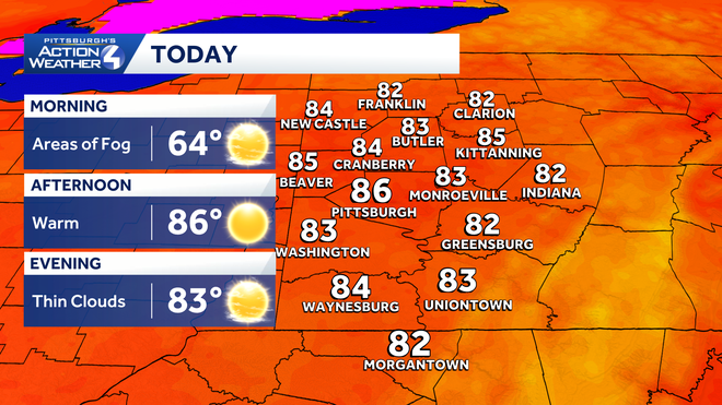
Today is your day to get outside without any worries. Sunshine takes over after patchy morning fog. It will be a warm afternoon with highs in the mid 80s. However, humidity will comfortable, making for a nice afternoon. High clouds arrive late in the day in advance of our next cold front.
Hearst OwnedHearst
A nice early summer afternoon around western PA with sunshine, warm temperatures and lower humidity.
Impact Day Sunday: Rain and storms
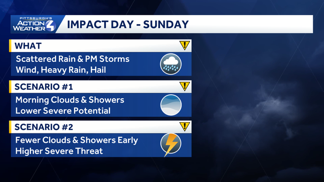
Sunday is an Impact Day with two chances at rain. A few morning showers will develop ahead of the cold front. How quickly the initial batch of rain moves out will determine our severe potential for later in the day.
Hearst OwnedHearst
The influence of morning clouds and showers will determine if severe storms materialize Sunday afternoon.
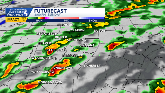
The best chance for strong thunderstorms will be in the afternoon and evening, especially if we see more sunshine. Still the front will bring widespread rain and some embedded thunderstorms. Gusty winds and heavy rain will be possible in any storm. Rain will end before sunset.
Hearst OwnedHearst
A cold front with scattered stronger thunderstorms between 2 p.m. and 6 p.m. prompts the Impact Day.
Cooler and quieter to begin next week
Sunday’s cold front will usher in below average temperatures for the first time in about two weeks. Highs will be in the 70s, lows will dip into the 50s thanks to very comfortable humidity levels. Our next rain chance is late Wednesday into Thursday with another cold front.
Hearst OwnedHearst
The forecast will feel more June-like next week.
TODAY: Mostly sunny, warm but not as humid. High: 86°.
TONIGHT: Clear to partly cloudy. Low: 64°.
SUNDAY – Impact Day: Early clouds and showers. Scattered PM rain and storms, some may be strong. Breezy, high: 80°, low: 56°.
MONDAY: Delightful with sun and clouds. Cooler and less humid. High: 72°, low: 55°.
TUESDAY: More sunshine. High: 76°, low: 58°.