
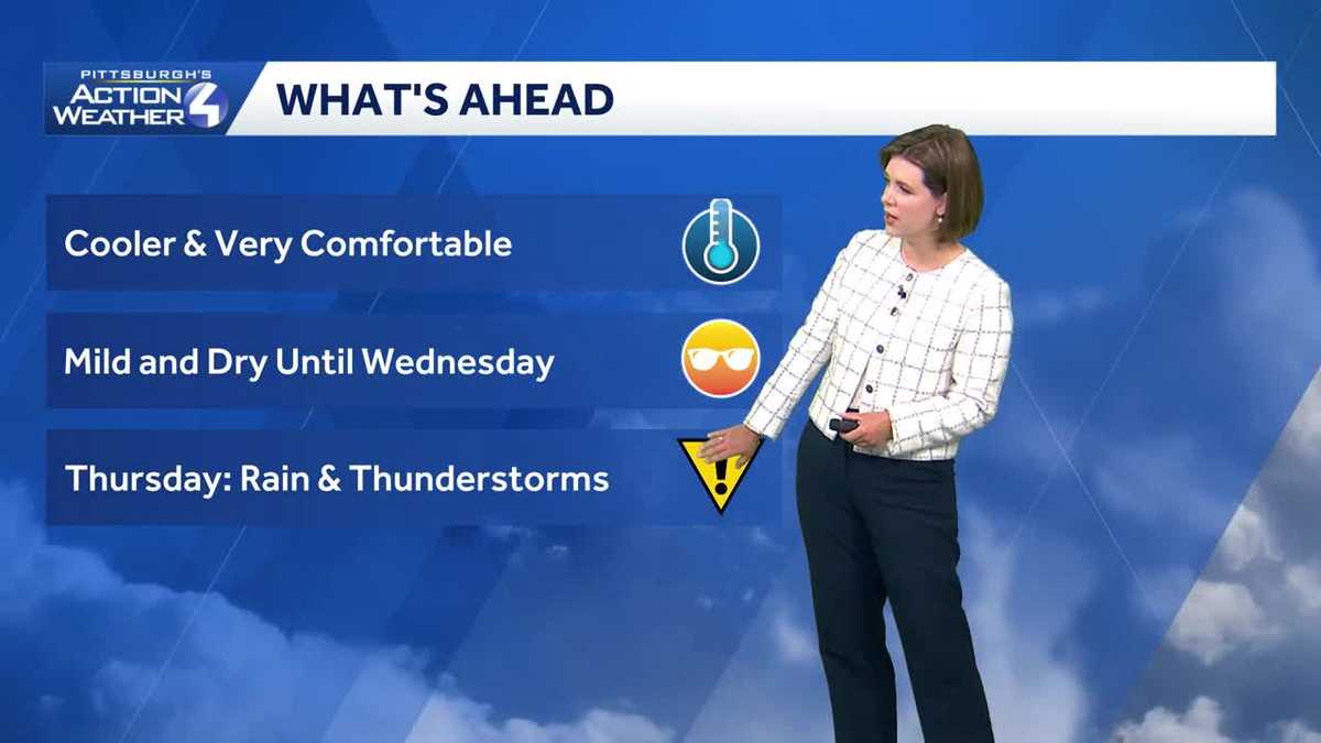
Western PA: Dry and comfortable to begin the week
Rain returns Wednesday night; Thursday is an Impact Day for rain and storms.
SUMMER WHEN INSPECTORS FOUND CORRODED STEEL IN A PIER. THERE, MUCH CALMER AFTER YESTERDAY’S ROUND OF SEVERE WEATHER. WE’RE DRYING THINGS OUT, BUT ALSO COOLING IT DOWN FOR THE START OF THE WEEK. BUT WE’RE NOT OUT OF THE WOODS QUITE JUST YET. WHEN IT COMES TO UNSETTLED, SUMMER LIKE CONDITIONS, RAIN WILL RETURN LATE WEDNESDAY. THAT LEADS TO OUR NEXT IMPACT DAY ON THURSDAY. AS WE WAKE UP THIS MONDAY MORNING CERTAINLY FEELS DIFFERENT OUTSIDE AS WE CUT BACK, THE HUMIDITY, COOL DOWN OUR TEMPERATURES, BUT ALSO SEE SOME AREAS OF FOG A LITTLE BIT MORE PROBLEMATIC IN AND AROUND THE PITTSBURGH INTERNATIONAL, ALSO EXTENDING BACK INTO BEAVER COUNTY, WHERE WE SAW SOME OF THAT EXTENSIVE STORM DAMAGE FROM LAST NIGHT, EVEN OUT TOWARDS MONROEVILLE WEST MIFFLIN, VISIBILITY AROUND SIX MILES AND SOME PATCHY FOG AS YOU HEAD UP INTO VENANGO COUNTY, TOO. SO JUST BE MINDFUL, ESPECIALLY IN RIVER VALLEY SPOTS, THAT’S WHERE YOU COULD SEE A LITTLE BIT OF A TRICKY START TO THE DAY. A BIT OF A BREEZE PICKS UP THROUGH THE AFTERNOON. THAT KEEPS US COMFORTABLY COOL, REFRESHING AS WE GO THROUGH YOUR MONDAY ONLY MID 60S UP ALONG I-80. THAT INCLUDES 66 IN OIL CITY MATCHES. THE TEMPERATURE FOR SLIPPERY ROCK 68 KITTANNING UPPER 60S IN NEW CASTLE AND INDIANA TODAY. CHECK OUT SEVEN SPRINGS JUST 61. CERTAINLY NOT FEELING LIKE IT SHOULD BE FOR THE MIDDLE OF JUNE. UPPER 60S ACROSS FAYETTE COUNTY. YOU’LL NOTICE CLOSER TO 70 IN MORGANTOWN, 71. ALSO OUR FORECAST IN PITTSBURGH. HOW ABOUT 70 FOR CANONSBURG? 68 IN GREENSBURG AND LATROBE. A LITTLE LATER ON TODAY IN YOUR FOUR DAY FORECAST, WE’RE GOING TO KEEP IT QUIET AND DRY OVER THE AT LEAST FORESEEABLE FUTURE. TONIGHT, TEMPERATURES BACKING OFF CLOSE TO 50. SO LEAVE THE WINDOWS OPEN. SKIES WILL BE PERFECTLY CLEAR, LITTLE MILDER COME TOMORROW AFTERNOON AS YOU FAST FORWARD INTO WEDNESDAY, THERE IS A MINIMAL SHOWER CHANCE EARLY IN THE DAY. I THINK THE BIGGER STORY WILL BE INCREASING CLOUDS FOLLOWED BY A RAIN CHANCE AFTER DARK, POSSIBLY EVEN PUSHING UNTIL AFTER MIDNIGHT. THAT AGAIN LEADS TO OUR IMPACT DAY ON THURSDAY. WE ARE TALKING ABOUT MORE HEAVY RAIN AROUND WESTERN PENNSYLVANIA. EVEN THE POSSIBILITY OF STRONG TO SEVERE THUNDERSTORMS. THIS RUN OF FUTURECAST BRINGS SOME OF THE ACTIVE WEATHER THROUGH RIGHT AROUND THE MORNING COMMUTE. WE’RE GOING TO CONTINUE TO FINE TUNE THAT TIMING AND WHAT IT MEANS FOR SEVERE WEATHER, TOO, AS DAMAGING WINDS AND MORE LOCALIZED FLASH FLOODING WILL BE A CONCERN FOR THAT IMPACT DAY ON THURSDAY, WE ARE DRYING OUT IN TIME FOR JUNETEENTH COME FRIDAY, ALSO THROUGH THE UPCOMING WEEKEND IN YOUR 4-DAY PLUS 4 MORE FORECAST, TEMPERATURES WILL RUN IN THE UPPER 70S THROUGH FATHER’S DAY. WE ARE SEEING SOME BREAKS IN THE CLOUDS, A FEW LITTLE SPRINKLES NORTH OF I 80. THEY’LL BE BREAKING DOWN AS WE CONTINUE THROUGHOUT THE MORNING. SEE SOME OF THOSE LOW CLOUDS OVER THE CITY THIS MORNING AS WE LOOK AT YOUR 12 HOUR FORECAST, THAT BREEZE OUT OF THE NORTHWEST KEEPING US IN THE 60S FOR MOST OF YOU
Western PA: Dry and comfortable to begin the week
Rain returns Wednesday night; Thursday is an Impact Day for rain and storms.

Updated: 7:00 AM EDT Jun 15, 2026
The next couple of days will bring some calm after the latest round of severe weather. A cooler, rather refreshing air mass settles into western Pennsylvania. Rain chances will hold off until Wednesday. Thursday is now an Impact Day for rain and storms, especially around the morning commute.Dry and comfortable start to the weekYesterday’s cold front has brought a refreshing air mass for the start of the new week. Clouds will gradually break through the afternoon with highs only around 70 degrees. Temperatures will dip close to 50° overnight. Tuesday will be slightly milder with more sunshine.Rain returns, Impact Day ThursdayA few showers will be around Wednesday morning followed by more rain overnight. Thursday is now an Impact Day. The morning hours look a little busier for the Pittsburgh area. Strong to severe thunderstorms are possible, especially southeast of the city. Damaging winds, localized flooding, hail and possibly a tornado are possible. Outside of the rain and storms, it will be a breezy and humid day.Drying out again by the weekendConditions will dry out on Juneteenth and stay quiet for Father’s Day weekend. Sunday is also the Summer Solstice. Although, temperatures won’t feel very summer-like for the start of the new season.TODAY: Cooler with clouds and sun. High: 71°.TONIGHT: Clear and refreshing, low: 51°.TUESDAY: Delightful with sunshine, clouds return late. High: 76°, low: 58°.WEDNESDAY: Increasing clouds with rain late. High: 80°, low: 65°.THURSDAY – Impact Day: Rain and storms, especially in the morning. Breezy. High: 83°, low: 62°.
PITTSBURGH —
The next couple of days will bring some calm after the latest round of severe weather. A cooler, rather refreshing air mass settles into western Pennsylvania. Rain chances will hold off until Wednesday. Thursday is now an Impact Day for rain and storms, especially around the morning commute.
Dry and comfortable start to the week
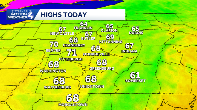
Yesterday’s cold front has brought a refreshing air mass for the start of the new week. Clouds will gradually break through the afternoon with highs only around 70 degrees. Temperatures will dip close to 50° overnight. Tuesday will be slightly milder with more sunshine.
Hearst OwnedHearst
Seasonably cool with gradual clearing around western PA this afternoon.
Rain returns, Impact Day Thursday
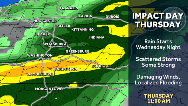
A few showers will be around Wednesday morning followed by more rain overnight. Thursday is now an Impact Day. The morning hours look a little busier for the Pittsburgh area. Strong to severe thunderstorms are possible, especially southeast of the city. Damaging winds, localized flooding, hail and possibly a tornado are possible. Outside of the rain and storms, it will be a breezy and humid day.
Hearst OwnedHearst
Thursday’s Impact Day will feature more heavy rain and the potential for strong to severe thunderstorms.
Drying out again by the weekend
Conditions will dry out on Juneteenth and stay quiet for Father’s Day weekend. Sunday is also the Summer Solstice. Although, temperatures won’t feel very summer-like for the start of the new season.
Hearst OwnedHearst
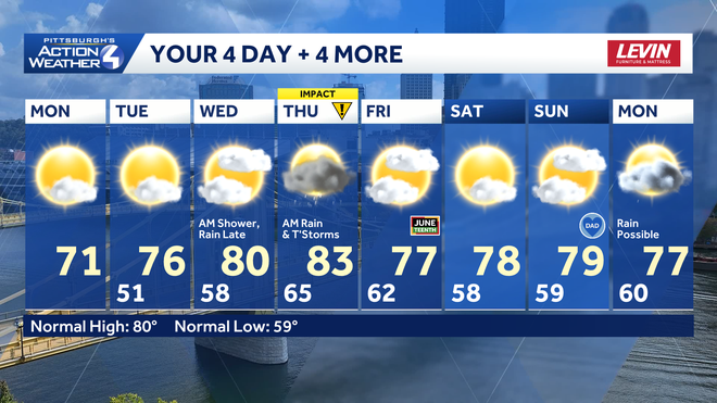
A bumpy ride through mid-week with more rain and storms. Conditions will dry out in time for the holiday weekend.
TODAY: Cooler with clouds and sun. High: 71°.
TONIGHT: Clear and refreshing, low: 51°.
TUESDAY: Delightful with sunshine, clouds return late. High: 76°, low: 58°.
WEDNESDAY: Increasing clouds with rain late. High: 80°, low: 65°.
THURSDAY – Impact Day: Rain and storms, especially in the morning. Breezy. High: 83°, low: 62°.