
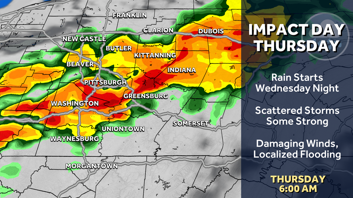
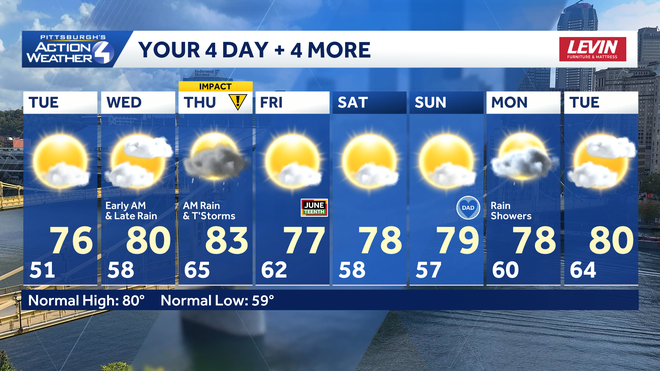
SEASONAL FOR US ON TUESDAY AND MORE SO ON WEDNESDAY AS WELL. IF YOU ARE MAKING PLANS FOR THE POOL TUESDAY, WEDNESDAY WILL WORK. WEDNESDAY WE SHOULD MAKE IT TO 80. WE ARE WATCHING FOR TWO SHOWER CHANCES ONE EARLY, ONE LATE. SO THE DAYTIME HOURS ON WEDNESDAY SHOULD BE DRY. AND THEN THURSDAY IS AN IMPACT DAY WITH RAIN AND THUNDERSTORMS IN THE MORNING. BUT THE BACK HALF OF THURSDAY LOOKS TO BE DRY. THEN WE WILL BE DRY AS WE HEAD THROUGH YOUR FATHER’S DAY WEEKEND. SO 76 IS YOUR HIGH TEMPERATURES. TOMORROW WE’RE STARTING AT 51, WHICH MEANS SOME SPOTS, ESPECIALLY OUTSIDE OF ALLEGHENY COUNTY, COULD START IN THE 40S TOMORROW MORNING. A COOL START, BUT A BETTER FINISH. 84 ON WEDNESDAY. AGAIN WITH THAT SHOWER CHANCE. EARLY AND LATE THAT MORNING. SHOWER CHANCE IS LIKELY BEFORE WE WAKE UP ON WEDNESDAY. AND AGAIN, THE DAYLIGHT HOURS WILL BE DRY UNTIL OUR NEXT BATCH OF RAIN STARTS ARRIVING LATE IN THE DAY ON THURSDAY, WHICH PROMPTS OUR IMPACT DAY FRIDAY. WE DRY OUT AT 77 AND WE STAY DRY AS WE HEAD THROUGH. YOUR FATHER’S DAY WEEKEND WILL BE IN THE UPPER 70S SATURDAY AND SUNDAY BEFORE RAIN CHANCES LOOK TO RETURN NEXT MONDAY AND HIGH TEMPERATURES RETURN BACK TO 80 AS WE KEEP SOME CLOUDS AROUND AS WE HEAD INTO NEXT TUESDAY. SO LET’S TALK ABOUT THOSE LATE DAY RAIN SHOWERS ON WEDNESDAY. AGAIN, THIS WILL BE IN ADVANCE OF OUR MAIN SYSTEM AS THE WARM FRONT LIFTS IN A COUPLE OF SHOWERS. AS WE GET PAST SUNSET ON WEDNESDAY, HEAVIER RAIN STARTS ARRIVING ONCE WE GET PAST MIDNIGHT WITH RAIN SHOWERS THROUGH THE NIGHT AND SOME EMBEDDED THUNDERSTORMS AS WELL. THESE WILL BE MORE SCATTERED VARIETIES WE’RE NOT EXPECTING NECESSARILY. WIDESPREAD SEVERE WEATHER. HEAVY RAIN IS MORE OF A BIGGER CONCERN THAN SEVERE WEATHER AT THIS POINT. WE’LL CONTINUE TO MONITOR THOSE TRENDS AS WE GET TOWARDS THE MORNING COMMUTE. THE HEAVIEST RAIN SHOULD BE EXITING OUT OF WESTERN PENNSYLVANIA, AND THEN WE WILL DRY OUT THROUGH MID MORNING WITH SUNSHINE RETURNING AS WE HEAD INTO YOUR THURSDAY AFTERNOON. SO IN THE CITY AND SOUTH AND EAST, WE’RE WATCHING FOR AN ELEVATED RISK OF SEEING POTENTIALLY FLASH FLOODING ON THURSDAY. THIS IS A LEVEL TWO OUT OF FOUR FROM THE WEATHER PREDICTION CENTER, WHERE RAINFALL TOTALS SOUTH OF THE CITY COULD POTENTIALLY GET TO AN INCH OR SO EVERYWHERE ELSE, ABOUT AN HALF AN INCH. SO WE’LL BE WATCHING THOSE RAINFALL POCKETS OF HEAVY RAIN AS WE HEAD INTO THURSDAY MORNING. SKIES HAVE CLEARED OUT FOR US ON ACTION. CAM 56 IS THE CURRENT TEMPERATURE. WINDS ARE LIGHT. COOL. START TOMORROW.
Western PA: Comfortable until an Impact Day Thursday
Rain returns Wednesday night; Thursday is an Impact Day for rain and storms.

Updated: 11:23 PM EDT Jun 15, 2026
The next couple of days will bring some calm after the latest round of severe weather. A cooler, rather refreshing air mass settles into western Pennsylvania. Rain chances will hold off until Wednesday. Thursday is now an Impact Day for rain and storms, especially around the morning commute.Dry and comfortable start to the weekYesterday’s cold front has brought a refreshing air mass for the start of the new week. Temperatures will dip close to 50° overnight. Tuesday will be slightly milder with more sunshine. Rain returns, Impact Day ThursdayA few showers will be around Wednesday morning followed by more rain overnight. Thursday is now an Impact Day. The morning hours look a little busier for the Pittsburgh area. Strong to severe thunderstorms are possible, especially southeast of the city. Damaging winds, localized flooding, hail, and possibly a tornado are the storm threats. Outside of the rain and storms, it will be a breezy and humid day.Drying out again by the weekendConditions will dry out on Juneteenth and stay quiet for Father’s Day weekend. Sunday is also the Summer Solstice. Temperatures won’t feel very summer-like for the start of the new season.TONIGHT: Clear and refreshing, low: 51°.TUESDAY: Delightful with sunshine, clouds return late. High: 76°, low: 58°.WEDNESDAY: Increasing clouds with rain late. High: 80°, low: 65°.THURSDAY – Impact Day: Rain and storms, especially in the morning. Breezy. High: 83°, low: 62°.
PITTSBURGH —
The next couple of days will bring some calm after the latest round of severe weather. A cooler, rather refreshing air mass settles into western Pennsylvania. Rain chances will hold off until Wednesday. Thursday is now an Impact Day for rain and storms, especially around the morning commute.
Dry and comfortable start to the week
Yesterday’s cold front has brought a refreshing air mass for the start of the new week. Temperatures will dip close to 50° overnight. Tuesday will be slightly milder with more sunshine.
Rain returns, Impact Day Thursday
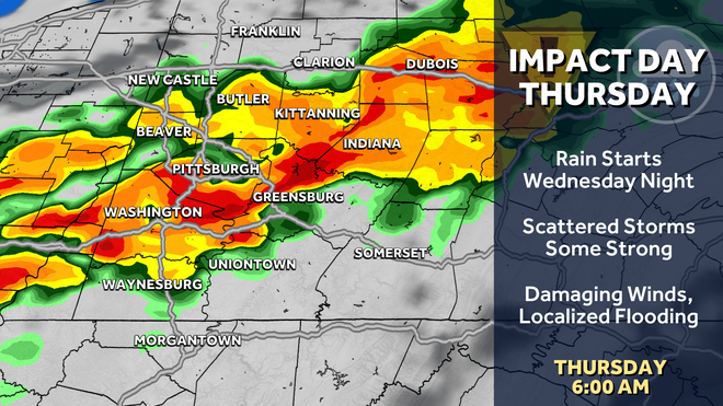
A few showers will be around Wednesday morning followed by more rain overnight. Thursday is now an Impact Day. The morning hours look a little busier for the Pittsburgh area. Strong to severe thunderstorms are possible, especially southeast of the city. Damaging winds, localized flooding, hail, and possibly a tornado are the storm threats. Outside of the rain and storms, it will be a breezy and humid day.
Hearst Owned
Thursday’s Impact Day will feature more heavy rain and the potential for strong to severe thunderstorms.
Drying out again by the weekend
Conditions will dry out on Juneteenth and stay quiet for Father’s Day weekend. Sunday is also the Summer Solstice. Temperatures won’t feel very summer-like for the start of the new season.
Hearst Owned
A bumpy ride through mid-week with more rain and storms. Conditions will dry out in time for the holiday weekend.
TONIGHT: Clear and refreshing, low: 51°.
TUESDAY: Delightful with sunshine, clouds return late. High: 76°, low: 58°.
WEDNESDAY: Increasing clouds with rain late. High: 80°, low: 65°.
THURSDAY – Impact Day: Rain and storms, especially in the morning. Breezy. High: 83°, low: 62°.