
Western Pennsylvania braces for storms with damaging winds and downpours
The heaviest rain will be before sunrise Thursday
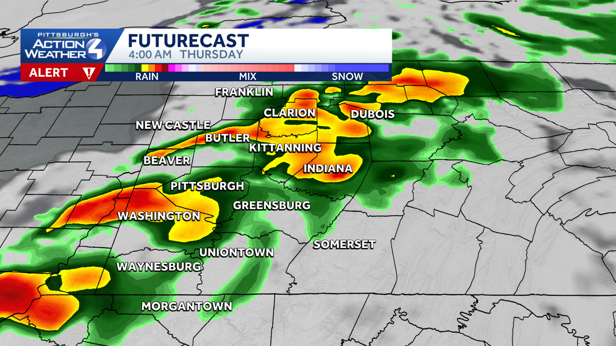
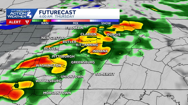
ALL RIGHT, LET’S GET ANOTHER CHECK OF PITTSBURGH’S ACTION WEATHER. YOU ARE TRACKING SOME CHANGES FOR TOMORROW SPECIFICALLY. YEAH, WE CERTAINLY ARE. ESPECIALLY EARLY IN THE MORNING. WE’LL HAVE SOME THUNDERSTORMS THAT WILL BE MOVING INTO THE AREA. SO THE TIMING OF THIS WILL HAVE SOME RAIN MOVING IN HERE IN THE NEXT COUPLE OF HOURS. AND BY 11 TO 8 A.M., THAT’S GOING TO BE THE MAIN WINDOW AS WE’LL HAVE STORMS BEGIN TO MOVE INTO THE AREA. AND THEN WE’LL HAVE STRONG WINDS NOT ONLY THROUGH THAT WINDOW, BUT THROUGH THE ENTIRE DAY TOMORROW WITH WIND GUSTS UP TO 40MPH. SO RAIN SHOWERS WITH POCKETS OF HEAVY RAIN THROUGH ABOUT 8:00. ISOLATED THUNDERSTORMS. THERE COULD BE SOME DAMAGING WIND, HEAVY RAIN, LOCALIZED FLOODING AND STRONG WINDS WHERE WE COULD SEE SOME TREES GET TOPPLED OUT THERE. TEMPERATURE WISE, THAT’S NOT AN ISSUE. WE’RE LOOKING AT A LOW DOWN, AROUND 70 DEGREES HIGHS INTO THE 80S. AND AGAIN IT WILL BE WINDY ALL DAY LONG. THE STORMS WILL OCCUR IN THE MORNING HOURS UP UNTIL ABOUT EIGHT 9:00 IN THE MORNING. IT IS A SEVERE WEATHER ALERT DAY ON THURSDAY, BUT BY THE TIME WE GET TO NOON ON THURSDAY, WE’RE ALREADY BACK TO SUNSHINE AND THAT WILL STAY WITH US ON FRIDAY, SATURDAY AND MOST OF SUNDAY. HIGH TEMPERATURES ON THOSE THREE DAYS WILL BE 78 TO 80 DEGREES. AND THEN SUNDAY NIGHT, THAT’S WHEN WE’LL HAVE A CHANCE FOR SOME RAIN SHOWERS. RETURNING IN CONJUNCTION WITH THE RAIN THAT IS GOING TO ARRIVE ON MONDAY, THAT WILL BE REALLY THE ONLY WET DAY WE’RE LOOKING AT NEXT WEEK. AS WE SEE SUNSHINE BACK IN THE FORECAST ON TUESDAY, WEDNESDAY AND THURSDAY AND TEMPERATURES AGAIN RIGHT ABOUT 80 DEGREES. SO THE CLOUDS ARE MOVING IN NOW. SHOWERS GET A LITTLE BIT CLOSER. AS WE WIDEN OUT THE SHOT. YOU’LL SEE OUT TO THE WEST THE RAIN THAT IS YET TO COME AND WILL BE MOVING INTO THE AREA AS WE GO OVERNIGHT INTO TOMORROW MORNING. SO CERTAINLY SOME RAIN AS WE GET TOWARDS 9:00 AND IN THE EARLY MORNING HOURS. BY 4 A.M. YOU CAN SEE THE POCKETS OF HEAVY RAIN, THE THUNDERSTORMS THAT WILL BE MOVING INTO THE AREA, AND JUST ABOUT EVERYBODY IS GOING TO BE IMPACTED BY THIS WITH NUMEROUS LIGHTNING STRIKES, THE HEAVY RAIN, STRONG WIND GUSTS, POSSIBLY DAMAGING WINDS AND THE THUNDER OUT THERE OVERNIGHT. HERE’S 7 A.M. MOST OF THE HEAVY RAIN LIKELY GOING TO BE FROM PITTSBURGH DOWN TO THE SOUTH. AND IT COULD BE SOME VERY INTENSE OR TORRENTIAL RAIN THAT WILL BE COMING DOWN AT THAT TIME BY THE TIME WE GET TO NOON, THIS IS ALL OVER WITH. WE’LL HAVE SUNSHINE RETURNING NOT ONLY FOR THURSDAY, BUT AS WE GO INTO FRIDAY AS WELL. WE WILL BE SEEING MOSTLY SUNNY SKIES FOR THE MOST PART. SO AS WE HEAD FROM MIDNIGHT INTO THE MORNING HOURS, WE’LL HAVE WIND GUSTS UP TO AROUND 35 TO 40MPH, AND THEN WE’LL GO THROUGH THE DAY. AND AGAIN, WE’LL STILL CONTINUE TO SEE WIND GUSTS IN SOME AREAS. THAT WILL BE UP TO 40MPH. SO YOUR 4-DAY PLUS 4 MORE, WE HAVE THE TOUGH MORNING OVERNIGHT INTO TOMORROW MORNING, SECOND HALF OF THE DAY ON THURSDAY. WE’LL CALM IT DOWN AS FAR AS SUNSHINE WILL BE RETURNING TO THE AREA. THE WIND WILL CONTINUE WITH GUSTS THROUGH THE EVENING HOURS AT 40MPH. AND THEN IT’S PRETTY QUIET ON FRIDAY. SATURDAY AS WELL AS SUNDAY. MONDAY WE HA
Western Pennsylvania braces for storms with damaging winds and downpours
The heaviest rain will be before sunrise Thursday

Updated: 2:39 AM EDT Jun 18, 2026
Downpours and strong winds are moving into Western Pennsylvania, marking another day of severe weather. Severe Weather Alert Day – Thursday Thursday is a Severe Weather Alert Day. Strong to severe thunderstorms are possible prior to 8 a.m. The storms may produce damaging winds, hail, and heavy rain.Storms will bring heavy rain, high winds, and lightning. An additional concern for Thursday is localized flooding from heavy rain. The excessive rainfall outlook has part of the region under a marginal risk for flash flooding, which adds to the Severe Weather Alert Day.By the time rain ends mid-morning, some locations could see upwards of an inch of rain. That much rain in a few hour span could cause flooding and ponding on roadways. The wind will continue through the day on Thursday with gusts topping 40 mph through the afternoon and early evening. This could cause additional problems with trees potentially toppling over due to saturated soils from the rain in the morning.Drying out Thursday, Friday and the weekendBy noon on Thursday sunshine will return to the area. Conditions will be dry on Friday/Juneteenth with sunshine and high temps in the upper 70s. It’ll stay comfortable and quiet through the Father’s Day weekend. There is a chance of rain returning as early as Sunday night, coming in with our next system that arrives on Monday bringing rain.OVERNIGHT – Severe Weather Alert Day: Rain, heavy at times with isolated storms. Low: 66°.THURSDAY – Severe Weather Alert Day: Rain and storms in the morning with the potential for flash flooding. Windy and humid through the afternoon. High: 83°, low: 57°. Wind gusts over 40 mph.FRIDAY: Partly cloudy and breezy. High: 78°, low: 57°.
Downpours and strong winds are moving into Western Pennsylvania, marking another day of severe weather.
Severe Weather Alert Day – Thursday
Thursday is a Severe Weather Alert Day. Strong to severe thunderstorms are possible prior to 8 a.m. The storms may produce damaging winds, hail, and heavy rain.
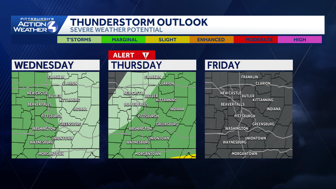
Storms will bring heavy rain, high winds, and lightning. An additional concern for Thursday is localized flooding from heavy rain. The excessive rainfall outlook has part of the region under a marginal risk for flash flooding, which adds to the Severe Weather Alert Day.
Hearst Owned
Pockets of heavy rain and isolated storms will move through Western PA during the early morning hours Thursday.
By the time rain ends mid-morning, some locations could see upwards of an inch of rain. That much rain in a few hour span could cause flooding and ponding on roadways.
The wind will continue through the day on Thursday with gusts topping 40 mph through the afternoon and early evening. This could cause additional problems with trees potentially toppling over due to saturated soils from the rain in the morning.
Drying out Thursday, Friday and the weekend
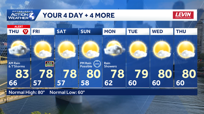
By noon on Thursday sunshine will return to the area. Conditions will be dry on Friday/Juneteenth with sunshine and high temps in the upper 70s. It’ll stay comfortable and quiet through the Father’s Day weekend. There is a chance of rain returning as early as Sunday night, coming in with our next system that arrives on Monday bringing rain.
Hearst Owned
Rain ushers in dry conditions until our next system arrives to close out the weekend and start next week.
OVERNIGHT – Severe Weather Alert Day: Rain, heavy at times with isolated storms. Low: 66°.
THURSDAY – Severe Weather Alert Day: Rain and storms in the morning with the potential for flash flooding. Windy and humid through the afternoon. High: 83°, low: 57°. Wind gusts over 40 mph.
FRIDAY: Partly cloudy and breezy. High: 78°, low: 57°.