
Pittsburgh: Impact Day Monday for heavy rain
A pop-up shower or storm is possible Saturday, otherwise we are staying dry until early Monday morning.
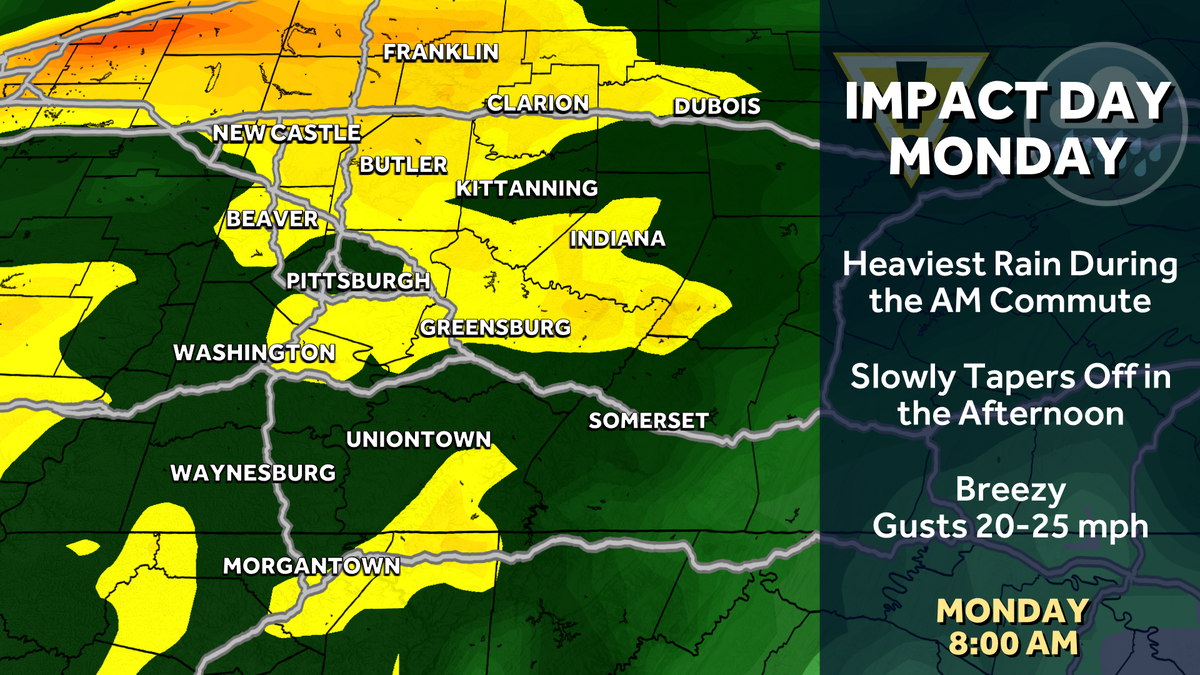
TREAT, RIGHT? YEAH, MOST OF THE WEEKENDS REALLY GREAT FOR US. REALLY. THE MAIN BLEMISH DOESN’T GET HERE UNTIL MONDAY. WE WILL WATCH FOR A SHOWER CHANCE. TOMORROW WILL BE FEW AND FAR BETWEEN, AND I THINK YOU’LL BE ABLE TO GET IN PLANS INCLUDING MONSTER JAM JUST FINE. WE’LL TURN MOSTLY CLOUDY AS WE HEAD THROUGH FATHER’S DAY. RAIN, THOUGH, DOES NOT GET HERE UNTIL WE GET LIKELY TO ABOUT 10 OR 11:00, PERHAPS HOLDING OFF UNTIL MIDNIGHT ON MONDAY. MONDAY, THOUGH, IS AN IMPACT DAY. RAIN WILL BE WITH US THROUGH THE MORNING. THAT’S WHEN THE HEAVIEST RAIN WILL FALL, AND THEN WE WILL GRADUALLY CLEAR THE RAIN AS WE HEAD INTO THE AFTERNOON AND EVENING. ON MONDAY, WE EXPECT TOMORROW TO SEE SOMETHING SIMILAR TO WHAT WE SEE THIS AFTERNOON. A COUPLE OF POP UP SHOWERS THAT ARE ALREADY FALLING APART ACROSS WESTERN PENNSYLVANIA. THESE ARE ACTUALLY INDUCED BY A LAKE BREEZE AS THE WIND IS NORTHWEST COMING OFF LAKE ERIE. SO A COUPLE LAKE SHOWERS, THESE WILL FIZZLE OUT, AND THEN AGAIN, WE’LL LIKELY SEE A LITTLE BIT OF COVERAGE OF THAT TOMORROW. BUT NOTHING I THINK YOU HAVE TO WORRY ABOUT 77 ON YOUR SATURDAY, 80 FOR YOUR FATHER’S DAY SUNDAY, OUR IMPACT DAY, MONDAY AT 76. THAT’S LIKELY GOING TO BE A SLOW CLIMB TO GET THERE. WE’LL DRY OUT TUESDAY AT 77. AND THEN NEXT WEEK IS REALLY SEASONAL. AS WE HEAD THROUGH THE NEXT LAST WEEK OF JUNE FOR US, WE’LL HOLD UPPER 70S, LOW 80S THAT IS, AND JUST SHY OF WHERE WE ARE SUPPOSED TO BE FOR THIS TIME OF YEAR. SO LET’S TALK ABOUT LATE SUNDAY INTO MONDAY. SO LATE SUNDAY AGAIN, STARTING AROUND 10:00, WE INTRODUCE THE CHANCE FOR SOME SHOWERS ACROSS WESTERN PENNSYLVANIA. IT LOOKS LIKE THE BULK OF THE RAIN GETS HERE AS WE HEAD PAST MIDNIGHT, AND THEN THE RAIN WILL BE HEAVY AT TIMES AS WE HEAD INTO THE EARLY MORNING HOURS. HERE IS 8:00 FOR YOU ON MONDAY. LOOK AT ALL OF THE HEAVY RAIN. THAT’S THE YELLOW AND ORANGE HERE ON FUTURECAST. POCKETS OF HEAVY DOWNPOURS ACROSS THE AREA. PERHAPS AN EMBEDDED THUNDERSTORM AS WELL. THE HEAVIEST RAIN WILL BEGIN EXITING BY LUNCHTIME, AND THEN THE RAIN SHOWERS SHOULD CLEAR AS WE GET LATE IN THE DAY, BUT IT MAY TAKE UNTIL WE GET TO THE BACK PART OF THE EVENING COMMUTE FOR US TO COMPLETELY DRY OUT ACROSS WESTERN PENNSYLVANIA. BY THE TIME WE’RE DONE, WE COULD BE TALKING UPWARDS OF AN INCH OF RAIN FOR EVERYBODY WITH LOCALLY HIGHER AMOUNTS. IF YOU SIT UNDERNEATH THOSE HEAVIER DOWNPOURS OR A THUNDERSTORM. SO FOR NOW, WE’RE WATCHING THE CHANCE FOR FLASH FLOODING ACROSS WESTERN PENNSYLVANIA. WE’LL KEEP AN EYE ON THAT AS WE HEAD INTO THE WEEKEND, PARTLY TO MOSTLY CLOUDY ON ACTION CAM WINDS STARTING TO DIE DOWN, STILL GUSTING TO 2376. IS THE CURRENT TEMPERATURE AT THE AIRPORT DROPPING TO THE 50S TONIGHT? MI
Pittsburgh: Impact Day Monday for heavy rain
A pop-up shower or storm is possible Saturday, otherwise we are staying dry until early Monday morning.

Updated: 4:26 PM EDT Jun 19, 2026
This weekend will be mainly dry and quiet. Rain chances pick up late Sunday, leading to an Impact Day for Monday. Dry for Most of the WeekendMoments of sunshine will linger through the weekend. A weak disturbance could spark a pop-up shower/storm Saturday afternoon, especially near US-422. Most of Western PA will stay dry for the majority of the weekend.Impact Day Monday for rain and stormsThere is a chance of rain returning as early as Sunday night ahead of our next system. Monday is an Impact Day for the rain chance. The heaviest rain will be falling during the morning commute with rain showers gradually decreasing once we get past lunch. A few thunderstorms may also be possible as the rain moves through the area. By the time rain comes to an end Monday evening, we are expecting about an inch of rain across Western PA with locally higher amounts from pockets of heavy rain and any embedded thunderstorms. Localized flooding may be an issue by late Monday.Mild start to summerSunday is also the Summer Solstice. Summer officially begins at 4:24 a.m. After Monday’s rain, we remain seasonal through next week with highs in the upper 70s to 80 degrees.TONIGHT: Mainly clear and comfortable. Low: 57°.SATURDAY: Pop-up afternoon showers are possible, otherwise a mix of sun and clouds. High: 77°, low: 59°.SUNDAY: Increasing clouds with evening rain. High: 80°, low: 62°.MONDAY – Impact Day: Rain and storms, especially heavy during the morning commute. High: 76°, low: 57°.
PITTSBURGH —
This weekend will be mainly dry and quiet. Rain chances pick up late Sunday, leading to an Impact Day for Monday.
Dry for Most of the Weekend
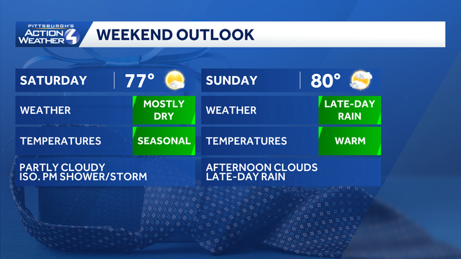
Moments of sunshine will linger through the weekend. A weak disturbance could spark a pop-up shower/storm Saturday afternoon, especially near US-422. Most of Western PA will stay dry for the majority of the weekend.
Impact Day Monday for rain and storms
Hearst Owned
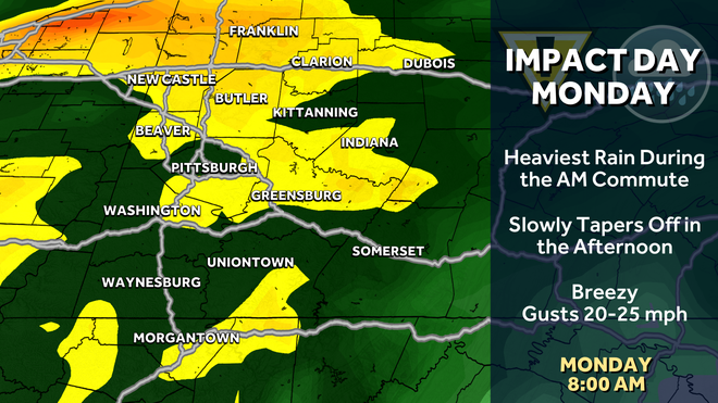
The heaviest rain Monday will fall during the morning commute. Monday is an Impact Day.
There is a chance of rain returning as early as Sunday night ahead of our next system. Monday is an Impact Day for the rain chance. The heaviest rain will be falling during the morning commute with rain showers gradually decreasing once we get past lunch. A few thunderstorms may also be possible as the rain moves through the area.
Hearst Owned
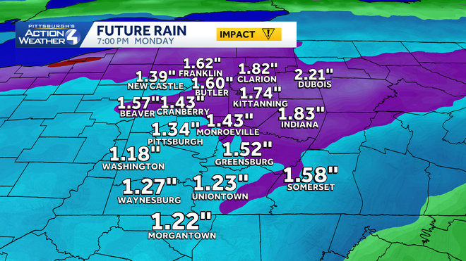
Rainfall totals will be around one inch from Monday’s rain.
By the time rain comes to an end Monday evening, we are expecting about an inch of rain across Western PA with locally higher amounts from pockets of heavy rain and any embedded thunderstorms. Localized flooding may be an issue by late Monday.
Mild start to summer
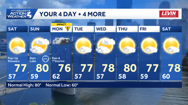
Sunday is also the Summer Solstice. Summer officially begins at 4:24 a.m. After Monday’s rain, we remain seasonal through next week with highs in the upper 70s to 80 degrees.
Hearst Owned
After Monday’s rain, the early days of summer will trend dry and mild around the Pittsburgh area.
TONIGHT: Mainly clear and comfortable. Low: 57°.
SATURDAY: Pop-up afternoon showers are possible, otherwise a mix of sun and clouds. High: 77°, low: 59°.
SUNDAY: Increasing clouds with evening rain. High: 80°, low: 62°.
MONDAY – Impact Day: Rain and storms, especially heavy during the morning commute. High: 76°, low: 57°.