
Flooding and strong storm threat in Western Pennsylvania on Monday afternoon
The focus will be southeast of Pittsburgh for more downpours and stronger storms.
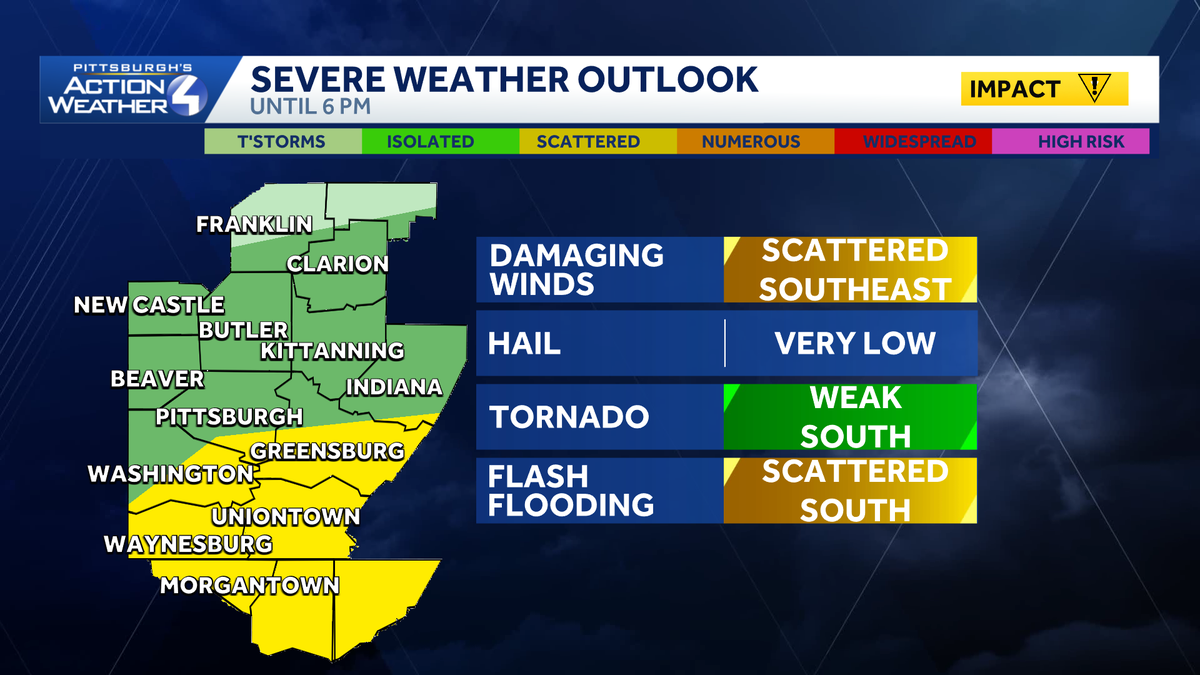
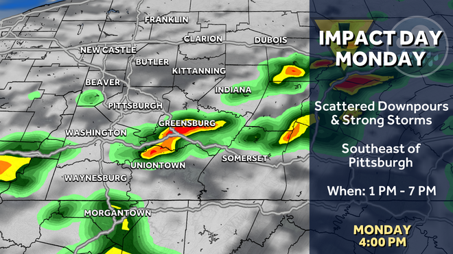
HOUSEHOLD ESSENTIALS WILL BE A BIG FOCUS OF THIS YEAR’S DEALS. JILL. WE’LL FIRST TO CASH IN ON MORE DOWNPOURS AND ALSO STRONGER THUNDERSTORMS FOR THE REST OF THE AFTERNOON. MAIN FOCUS AGAIN, STILL GOING TO BE FROM PITTSBURGH TOWARDS THE SOUTH AND EAST. DAMAGING WINDS LEADING THE WAY WITH OUR SEVERE THREATS. BUT WE CAN’T OVERLOOK A WEAK TORNADO SPIN UP. ALSO, AS WE GO THROUGH THE AFTERNOON. AND FLASH FLOODING WILL ALSO BE AN ISSUE. SOME OF THE HEAVIEST RAIN RIGHT NOW IS GOING TO IMPACT SPOTS LIKE SEVEN SPRINGS ALSO EXTENDS BACK INTO WESTERN SOMERSET COUNTY. CONNELLSVILLE, YOU’RE STARTING TO DRY OUT. BRAND NEW CELLS STARTING TO SHOW UP IN NORTHERN WEST VIRGINIA, TAKING AIM AT MORGANTOWN RIGHT NOW. THAT’S WHERE EVERYTHING WILL BE FILING IN FROM AS WE GO THROUGH THE AFTERNOON. SO WHILE THE SCENE IS PRETTY QUIET CLOSER TO PITTSBURGH, ESPECIALLY NORTH AND WEST, THIS IS REALLY JUST THE BEGINNING OF PHASE TWO OF OUR IMPACT DAY. THOSE STORMS CONTINUE TO BUILD TOWARDS THE NORTH, AND REALLY THE WINDOW FOR SEVERE WEATHER WILL BE PRETTY ACTIVE HERE BETWEEN ABOUT NOW AND LET’S SAY FOUR AND 5:00 THIS AFTERNOON. SO THINGS COULD HAPPEN VERY QUICKLY AS WE’RE OUT AND ABOUT. YOU WILL NOTICE PITTSBURGH REALLY KIND OF THE WALL HERE. ANYTHING THAT HAPPENS TO BE SOUTH AND EAST, MUCH QUIETER THE FARTHER NORTH AND WEST YOU ARE FROM THE CITY OF PITTSBURGH. ONCE WE HIT ABOUT 5:00, A LOT OF SEVERE INGREDIENTS ARE PULLING AWAY. SO WE WILL SEE THE RADAR CLEAR UP PRETTY QUICKLY AS WE GO THROUGH THE EVENING HOURS, PUSHING PAST THE EVENING COMMUTE, BUT STILL AN IMPACT DAY FOR THAT HEAVY RAIN, SCATTERED THUNDERSTORM THREAT, ESPECIALLY SOUTH AND EAST OF PITTSBURGH, 76 OR HIGH TEMPERATURE. THEN THINGS IMPROVE THROUGH THE MIDDLE OF THE WEEK, NOT ONLY WITH SUNSHINE, BUT ALSO OUR TEMPERATURES STARTING TO WARM UP INTO THE 80S COULD SEE A LITTLE BIT MORE RAIN AND STORM ACTION BEGINNING LATE ON THURSDAY. WE’LL TALK ABOUT THAT HERE IN JUST A SECOND. GLOOMY SCENE OVER DOWNTOWN PITTSBURGH WITH ACTION CAM RIGHT NOW. AGAIN, STILL A LITTLE STORMY FOR US THROUGH ABOUT FIVE AT 6:00. SKIES WILL BE MOSTLY CLOUDY AS WE GO THROUGH THE OVERNIGHT HOURS, WITH TEMPERATURES DIPPING CLOSE TO 60 ON TAP TOMORROW. IT’S ALMOST LIKE THE STORMS WERE NEVER HERE, AS WE’LL BRING MORE SUNSHINE AS THE DAY GOES ON. A PLEASANT START TO THE DAY WITH TEMPERATURES CLOSE TO 60. A LITTLE BIT OF A BREEZE AS TEMPERATURES WILL CLIMB INTO THE MID TO UPPER 70S FOR YOUR TUESDAY. MORE SUNSHINE 80 ON WEDNESDAY. THEN IT’S THURSDAY. THAT WILL BE MONITORING POTENTIAL FOR RAIN. THIS LOOKS TO BE COMING IN VERY LATE IN THE DAY, PROBABLY INTO THE EVENING HOURS, AND THINGS COULD BE A BIT WETTER AS WE GO THROUGH THE OVERNIGHT INTO FRIDAY. THIS SYSTEM IS GOING TO HANG AROUND JUST A LITTLE BIT SO KEEPS THINGS UNSETTLED THROUGH AT LEAST THE START OF THE WEEKEND. BUT WE’RE NOT EXPECTING EXPECTING ANY WASHOUTS. THEN, AS WE ENTER THE FINAL WEEK
Flooding and strong storm threat in Western Pennsylvania on Monday afternoon
The focus will be southeast of Pittsburgh for more downpours and stronger storms.

Updated: 1:21 PM EDT Jun 22, 2026
Monday is an Impact Day with scattered downpours and the potential for a few severe storms this afternoon, especially southeast of Pittsburgh.Areas northwest of Pittsburgh stay dry, while to the southeast, more downpours and the potential for severe storms will fire up. It is a dual threat for flash flooding and severe storms around the I-70 corridor.Interactive radar: Track storms as they move through the areaWTAE app: Download it now to stay connected with breaking news & weatherSevere weather alerts: Get free alerts to your phone or email Storm threats include damaging winds and a low-end tornado risk. The coverage of thunderstorms will be scattered in nature. Flash flooding could arise with any additional heavy rainfall. Looking for more news in your area | Subscribe to the WTAE YouTube ChannelThe low pulls away just as we start to lose any influence from daytime heating. The remaining storms and rain will fizzle after 6 p.m.Download the WTAE app to stay connected with breaking news. Sign up for our email newsletters to get breaking news in your inbox.
PITTSBURGH —
Monday is an Impact Day with scattered downpours and the potential for a few severe storms this afternoon, especially southeast of Pittsburgh.
Areas northwest of Pittsburgh stay dry, while to the southeast, more downpours and the potential for severe storms will fire up. It is a dual threat for flash flooding and severe storms around the I-70 corridor.
Hearst OwnedHearst
Scattered downpours and stronger thunderstorms are focused southeast of Pittsburgh through late-day.
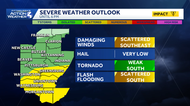
Storm threats include damaging winds and a low-end tornado risk. The coverage of thunderstorms will be scattered in nature. Flash flooding could arise with any additional heavy rainfall.
Looking for more news in your area | Subscribe to the WTAE YouTube Channel
The low pulls away just as we start to lose any influence from daytime heating. The remaining storms and rain will fizzle after 6 p.m.
Hearst OwnedHearst
A dual severe and flash flooding threat near I-70.
Download the WTAE app to stay connected with breaking news. Sign up for our email newsletters to get breaking news in your inbox.