
Western Pa. storms Monday slowly end | Next system expected late in the week
PITTSBURGH’S ACTION TRAFFIC. I’M LILY COLEMAN. WELL, WE DIDN’T EXACTLY JUST KIND OF EASE INTO THE WEEK. A LOT OF ACTIVITY TODAY. YES, WE DID HAVE A LOT OF ACTIVITY. TORNADO WARNINGS, CERTAINLY SOME ROTATION OUT THERE. VERY HEAVY RAIN AND LIGHTNING AND STRONG WINDS AS WELL. WE’RE JUST ABOUT TO THE END OF IT. WE STILL HAVE A FLASH FLOOD WARNING IN EFFECT FOR FAYETTE COUNTY. YOU CAN SEE FARMINGTON THERE. THAT’S UNTIL 9:00 TONIGHT. THEY HAVE HAD A LOT OF RAIN IN THAT AREA, POSSIBLY UP TO ONE AND A HALF, TWO INCHES OF RAIN. THEY’RE STILL NOT DONE WITH THE RAIN. IT WILL BE MOVING OUT IN THE NEXT HOUR OR SO. BUT A LOT OF RAIN IN THOSE AREAS. SO FLASH FLOOD WARNING CREEKS, STREAMS COULD COME OUT OF THEIR BANKS OR YOU HAVE PONDING ON THE ROADWAYS. IF YOU’RE DRIVING IN THAT AREA. SO THIS IS CONTINUING TO MOVE OFF TOWARDS THE EAST. YOU CAN SEE THE HEAVY RAIN MOVING EAST. AND ONCE WE GET DONE WITH THAT, WE’RE GOING TO BE IN PRETTY GOOD SHAPE. WE HAVE MAYBE A FEW SPRINKLES, BUT WE HAVE CLOUDS OVERNIGHT INTO THE MORNING HOURS AND THAT’S PRETTY MUCH IT. THEN WE WILL HAVE SUNSHINE. SO SOME CLOUDS IN THE MORNING TILL ABOUT 9 A.M. LOW TEMPERATURE DOWN AROUND 60 DEGREES. HIGHS IN THE UPPER 70S. AND THEN WE’LL JUST HAVE SUNSHINE TO FINISH OUT THE DAY. SO WE’LL TURN INTO A PRETTY NICE DAY. YOU CAN SEE THAT WE WILL HAVE THAT SUNSHINE RIGHT ON THROUGH UNTIL 5:00 TO 8:00 AT NIGHT. SO 78 FOR YOUR HIGH ON TUESDAY. WEDNESDAY, WE’RE AT 80 DEGREES, MOSTLY SUNNY SKIES, AND IT STAYS WARM IN THE 80S. THAT STARTS OUR STRETCH OF 80 DEGREE DAYS, 84 ON THURSDAY AND 83 ON FRIDAY. NOW FRIDAY AND SATURDAY, THAT’S OUR TWO DAYS WHERE WE’LL HAVE OUR BEST CHANCE OF SOME SHOWERS AND ISOLATED THUNDERSTORMS THAT WILL BE IN THE AREA. THEN WE DRY OUT AGAIN TOWARDS THE END OF THE WEEKEND AND EARLY NEXT WEEK. BUT THOSE TEMPERATURES STAY VERY WARM AND ABOVE NORMAL. SO AS WE LOOK AT TONIGHT, YOU CAN SEE THE SHOWERS WILL BE DEPARTING THE AREA CLOUDS WITH US IN THE MORNING. AND THEN WE’LL HAVE THE SKIES. THAT WILL CLEAR OUT PRETTY QUICKLY IN THE MORNING. AND BY THE TIME WE GET TO NOON, CERTAINLY WE’LL HAVE MOSTLY SUNNY SKIES. AND THEN WE GO INTO WEDNESDAY, WHERE WE WILL ALSO HAVE A LOT OF SUNSHINE AS WE HEAD THROUGH THE DAY. THURSDAY, A LITTLE BIT OF CHANGE. WE’LL HAVE MORE CLOUDS. IT WILL BE MOVING THROUGH AND A COUPLE OF AREAS OF OR POCKETS OF RAIN THAT WILL PUSH INTO THE REGION, BUT NOT A LOT. MOST OF IT WILL BE LIGHT THAT WILL MOVE ACROSS THE AREA. MOST LOCATIONS WILL STAY DRY AS FAR AS WIND. TOMORROW WE’LL SEE WIND GUSTS UP TO AROUND 20MPH, SO THAT WILL BE IN THE IN THE BREEZY RANGE. TEMPERATURES. HERE’S YOUR START OF THE 80 DEGR
Western Pa. storms Monday slowly end | Next system expected late in the week

Updated: 7:42 PM EDT Jun 22, 2026
Rain will clear, and Western Pennsylvania will begin to dry out Monday night and into Tuesday, following fast-moving storms through the area. The next system Pittsburgh’s Action News 4 is keeping an eye on arrives late Thursday into Friday. Interactive radar: Track storms as they move through the areaWTAE app: Download it now to stay connected with breaking news & weatherSevere weather alerts: Get free alerts to your phone or emailStorms depart the region, sunny days aheadHigh pressure will build in on Tuesday & Wednesday. After some morning clouds on Tuesday, skies will clear. Wednesday will be mostly sunny.Temperatures will reach the upper 70’s on Tuesday. Then, we start our stretch of 80 degree days.The next system to watchA weak system approaches to finish out the week and into the start of the weekend. Rain could arrive as early as Thursday evening. Shower chances will linger into Friday and Saturday.Seasonal first week of summerIn the meantime, temperatures remain seasonal for the first week of summer. Highs will peak around 80 degrees with comfortable humidity. A little more heat builds in for the final weekend of June.OVERNIGHT: Mostly cloudy. Low 60°.TUESDAY: Partly cloudy and pleasant. High: 78°, low: 56°.WEDNESDAY: More sunshine and a tad warmer. High: 80°, low: 60°. Download the WTAE app to stay connected with breaking news. Sign up for our email newsletters to get breaking news in your inbox.
PITTSBURGH —
Rain will clear, and Western Pennsylvania will begin to dry out Monday night and into Tuesday, following fast-moving storms through the area.
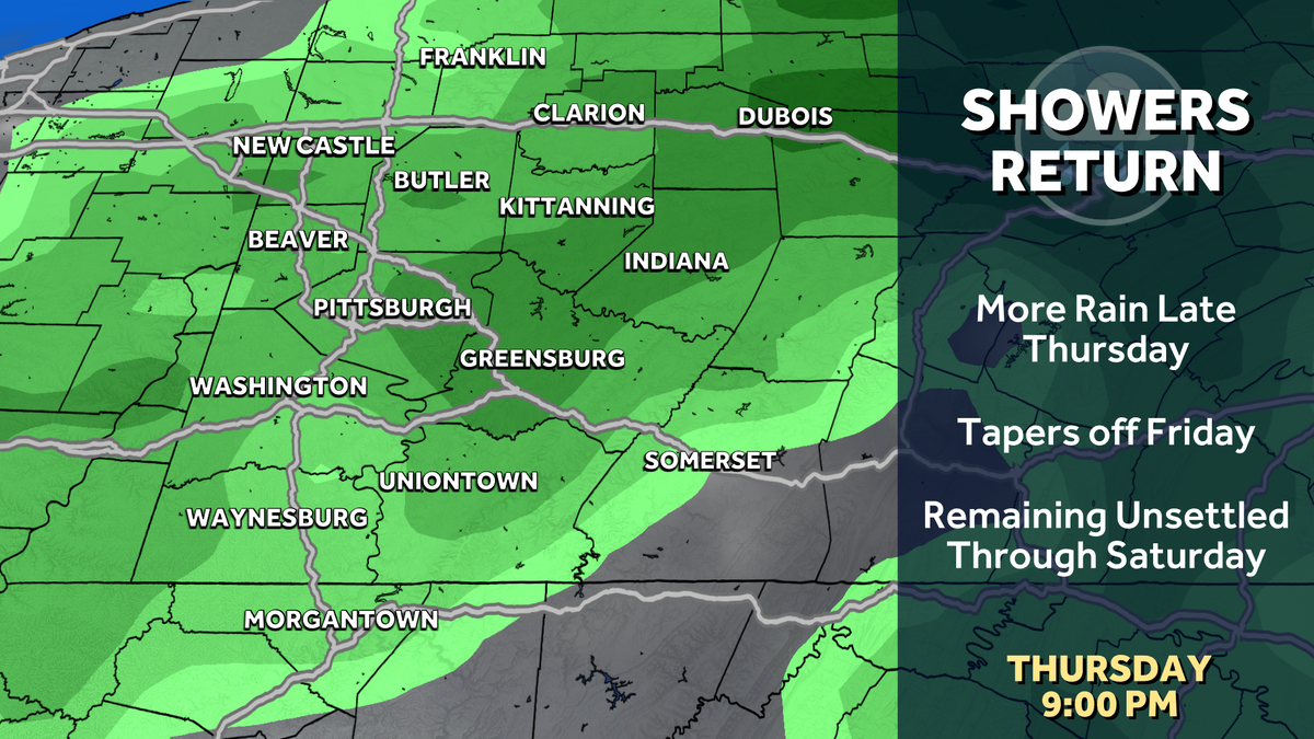
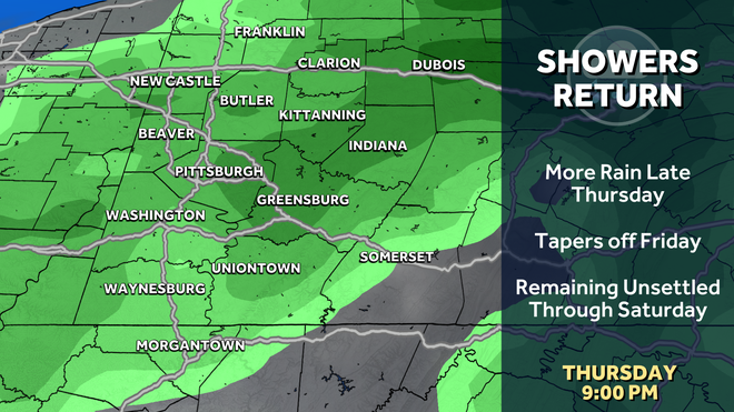
The next system Pittsburgh’s Action News 4 is keeping an eye on arrives late Thursday into Friday.
Storms depart the region, sunny days ahead
High pressure will build in on Tuesday & Wednesday. After some morning clouds on Tuesday, skies will clear. Wednesday will be mostly sunny.
Temperatures will reach the upper 70’s on Tuesday. Then, we start our stretch of 80 degree days.
The next system to watch
A weak system approaches to finish out the week and into the start of the weekend. Rain could arrive as early as Thursday evening. Shower chances will linger into Friday and Saturday.
Seasonal first week of summer
In the meantime, temperatures remain seasonal for the first week of summer. Highs will peak around 80 degrees with comfortable humidity. A little more heat builds in for the final weekend of June.
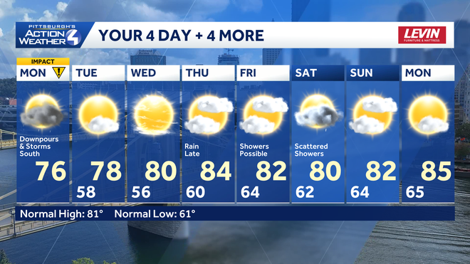
OVERNIGHT: Mostly cloudy. Low 60°.
TUESDAY: Partly cloudy and pleasant. High: 78°, low: 56°.
WEDNESDAY: More sunshine and a tad warmer. High: 80°, low: 60°.
Download the WTAE app to stay connected with breaking news. Sign up for our email newsletters to get breaking news in your inbox.