
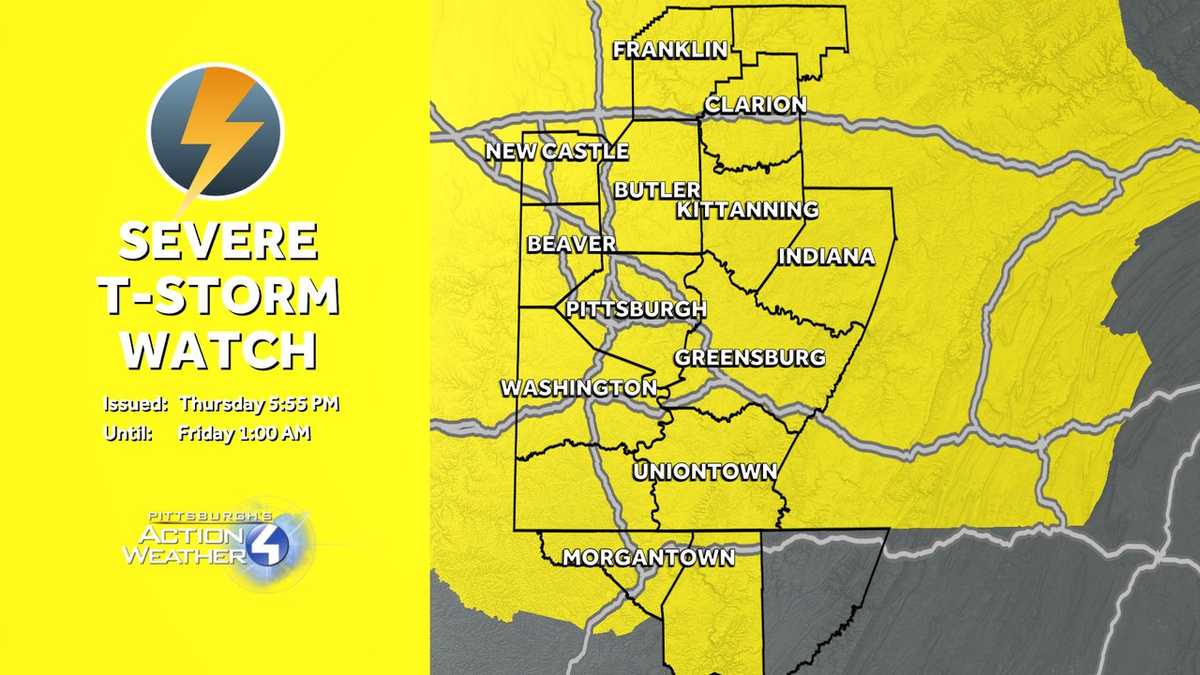
Severe thunderstorm watch issued in Western Pennsylvania
SECOND WAVE THAT WON’T BE AS STRONG, BUT THAT WILL BE MOVING IN LATER TONIGHT AS WELL. TOMORROW WE’RE LOOKING AT TEMPERATURES DROPPING DOWN INTO THE 60S. HIGHS WILL TOP OUT RIGHT AROUND 80 DEGREES. MUCH OF THE DAY WILL BE DRY AS WE HEAD THROUGH TOMORROW, AND THEN WE’LL HAVE RAIN THAT’S GOING TO ARRIVE AS WE HEAD INTO TOMORROW NIGHT. AND THAT WILL LAST INTO SATURDAY MORNING, SUNDAY AND MONDAY. BOTH DAYS WILL BE SEEING PARTLY CLOUDY SKIES AS TEMPERATURES RAMP UP TO 84 AND 89 DEGREES. AND THEN IT GETS HEATED AS WE GO INTO NEXT WEEK, TUESDAY, WEDNESDAY, THURSDAY AND FRIDAY. ALL IMPACT DAYS DUE TO THE HEAT ALL DAYS WILL BE WELL INTO THE 90S EVEN HIGHER WITH HUMIDITY LEVELS. SO FOR TONIGHT, YOU CAN SEE THE CELLS THAT WILL BE MOVING IN. THE THUNDERSTORMS WILL PUSH ACROSS BY TOMORROW MORNING. WE’LL HAVE CLOUDS THAT WILL BE WITH US ON FRIDAY MORNING. AND THEN WE GO THROUGH THE DAY. IT’S DRY THROUGH MUCH OF THE DAY ON FRIDAY. IT’S NOT UNTIL WE GET LATE ON FRIDAY NIGHT THAT WE’LL SEE THOSE SHOWERS MOVE IN. THEY’LL BE WITH US INTO EARLY ON SATURDAY MORNING. BY ABOUT NINE, 10:00 THEY’LL BE OUT OF HERE AND WE MAY EVEN SEE A LITTLE BIT OF SUNSHINE BY THE END OF THE DAY ON SATURDAY AND THEN ON SUNDAY, ALSO A CHANCE OF A LITTLE BIT OF SHOWERS OR A LITTLE BIT OF SUNSHINE MOVING IN. SO WE WILL KEEP IT IN THE 80S OR AT 80 FRIDAY AND SATURDAY WITH A LITTLE BIT OF RAIN MOVING IN SUND
A severe thunderstorm watch has been issued for counties in Western Pennsylvania on Thursday night.The National Weather Service said the watch will be in effect until 1 a.m. Friday.More: Read the weather alert for your countyInteractive radar: Track storms in your areaLearn how to enable automatic weather alerts on the WTAE app Thursday is an Impact Day with scattered showers and isolated thunderstorms. The main storm threats include heavy downpours and isolated gusty winds.The front will drift south Friday before stalling, keeping rain chances on Friday low. Rain ramps back up Friday night and into Saturday morning before drying out Saturday afternoon.Download the WTAE app to stay connected with breaking news. Sign up for our email newsletters to get breaking news in your inbox.
PITTSBURGH —
A severe thunderstorm watch has been issued for counties in Western Pennsylvania on Thursday night.
The National Weather Service said the watch will be in effect until 1 a.m. Friday.
Thursday is an Impact Day with scattered showers and isolated thunderstorms. The main storm threats include heavy downpours and isolated gusty winds.
The front will drift south Friday before stalling, keeping rain chances on Friday low. Rain ramps back up Friday night and into Saturday morning before drying out Saturday afternoon.
Download the WTAE app to stay connected with breaking news. Sign up for our email newsletters to get breaking news in your inbox.