
Pittsburgh: Warmer with pop-up showers Sunday
A “typical” summer’s day ahead of big heat and humidity.
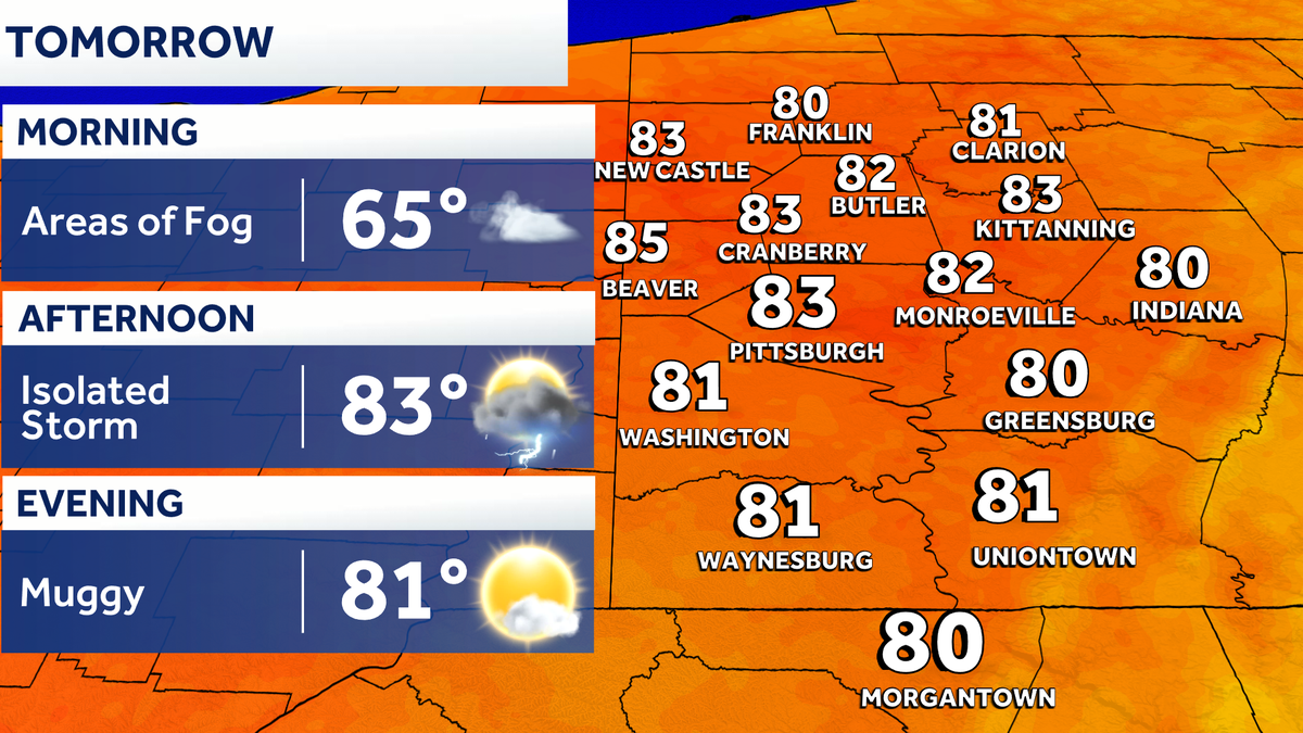
Well, Jill, *** lot going on with the weather. The downpours when they came, they came hard, right? And they’re very small, very teeny tiny and localized, but right, they have meant business we’ve gone through this afternoon. We could see another batch coming in as we work through the day tomorrow, although the coverage looks to be *** little bit more sporadic as we wind down this final weekend of June. In the meantime, we’re focused on the drying out trend as we go through this evening. Some areas of fog will form by daybreak tomorrow. Let’s look at future casting work through your Sunday Morning hours are going to be just fine. It will be. Noon that you can see *** few of those showers and even very rogue thunderstorms bubbling up. Action should fade as we approach 67 o’clock in the evening. But again, just something to be mindful of as you are out and about enjoying the weekend. Next big story though, it’s gonna be all about the heat and high humidity next week. Already we have 4 impact days in *** row, as you can see high temperatures well into the 90s. Some air you can wear will make it feel like the triple digits and that really is just the beginning of an extended stretch of heat as we. Into the early days of July, let’s check out the radar right now. Just south of Monroeville, we are seeing *** decent little shower that’s pulling past Pitcairn. Meanwhile for North Huntington, getting closer to Jeannette Greensburg. Also, as you look over towards Unity Township, skies have opened up. You’ve seen some of that steady rain for the past several minutes, and these are some slow moving downpours, especially across Westmoreland County as we’re working through this evening. But overall things are slow to move because we have *** stationary boundary that is going to be sinking southward as it goes through this evening. Things will dry out as you lose some daylight. And then on the flip side, we watch some areas of fog form towards daybreak tomorrow, 83 for your Sunday with an outside chance of *** shower or thunderstorm. Then things start to heat up on Monday, our four impact days in *** row starting on Tuesday, we more than likely will need to upgrade *** day or two depending on how toasty those temperatures get and maybe even extend our impact days into your Fourth of July weekend and your 4 day plus 4 more. Tomorrow temperatures landing around. 80 in most neighborhoods it is going to feel sticky with those shower and storm chances through the afternoon and again our heat wave kicks off on Tuesday, an extended stretch of impact days, potentially your 1st 90 degree day of the year with that air you can wear feels like temperatures will be in the triple digits and will continue to swelter through the 4th of July. It’s not just during the day, it’s also at night. Check out those low temperatures, only low to mid 70s, so not much relief, and Mother Nature could provide some fireworks of her own with storm chances starting on Friday.
Pittsburgh: Warmer with pop-up showers Sunday
A “typical” summer’s day ahead of big heat and humidity.

Updated: 6:55 PM EDT Jun 27, 2026
Conditions dry out overnight with areas of fog forming by daybreak. Another round of shower will bubble up Sunday afternoon. It is all about the heat and humidity next week. A slew of Impact Days begins on Tuesday.Drying out, fog late tonightShowers will fizzle with the loss of daylight. Areas near the West Virginia border will be the last to dry out. Areas of fog will develop after midnight. Visibility could dip below a mile in river valleys and areas that were more on the damp side today.Mainly dry SundayThe fog will linger through 9 a.m. As the sun comes out through the afternoon, another round of showers and storms will bubble up. Most of the areas will remain dry. Summertime heat and humidity start to kick in too.Four Impact Days for high heat and humidityThe heat cranks up next week! And it’s not just the heat, “air you can wear” is ahead too. Scorching heat starts Tuesday and continues through at least Friday. Each day will be Impact Day with daytime highs in the mid 90s and the feels like temperatures potentially over 100 degrees. One day of the high heat and humidity would be enough, but we need to be especially cautious as a heat wave settles in around western PA.Some relief could come if storms happen to fire. Showers and/or storms are possible each day of the Independence Day weekend. It is hard to say this far out if this will hold, let alone if activity will impact daytime plans or fireworks displays.TONIGHT: Showers end around sunset, areas of fog ahead of daybreak. Low: 65°.SUNDAY: Pop-up afternoon showers or storms. Partly cloudy and warmer. High: 83°, low: 68°.MONDAY: Sticky with feels like temperatures in the mid to upper 90s. High: 88°, low: 70°.TUESDAY – Impact Day: Hot and humid with triple digit heat indices. High: 94°, low: 73°
PITTSBURGH —
Conditions dry out overnight with areas of fog forming by daybreak. Another round of shower will bubble up Sunday afternoon. It is all about the heat and humidity next week. A slew of Impact Days begins on Tuesday.
Drying out, fog late tonight
Showers will fizzle with the loss of daylight. Areas near the West Virginia border will be the last to dry out. Areas of fog will develop after midnight. Visibility could dip below a mile in river valleys and areas that were more on the damp side today.
Mainly dry Sunday
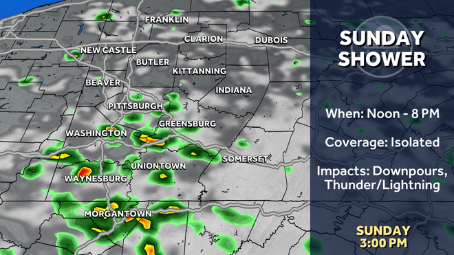
The fog will linger through 9 a.m. As the sun comes out through the afternoon, another round of showers and storms will bubble up. Most of the areas will remain dry. Summertime heat and humidity start to kick in too.
Hearst OwnedHearst
Pop-up showers and storms are possible Sunday afternoon for southwestern PA.
Four Impact Days for high heat and humidity
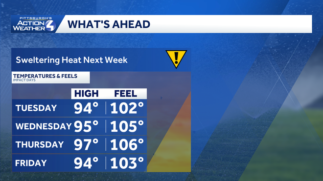
The heat cranks up next week! And it’s not just the heat, “air you can wear” is ahead too. Scorching heat starts Tuesday and continues through at least Friday. Each day will be Impact Day with daytime highs in the mid 90s and the feels like temperatures potentially over 100 degrees. One day of the high heat and humidity would be enough, but we need to be especially cautious as a heat wave settles in around western PA.
Hearst OwnedHearst
Sweltering heat and humidity will likely prompt several days of a Heat Advisory or Extreme Heat Warning.
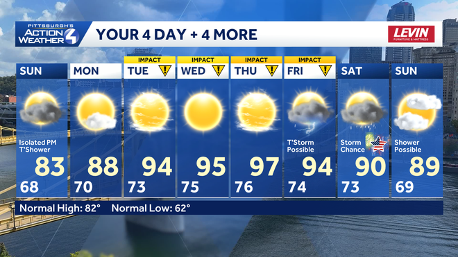
Some relief could come if storms happen to fire. Showers and/or storms are possible each day of the Independence Day weekend. It is hard to say this far out if this will hold, let alone if activity will impact daytime plans or fireworks displays.
Hearst OwnedHearst
Some of Mother Nature’s fireworks are possible as you are making plans for July 4th weekend.
TONIGHT: Showers end around sunset, areas of fog ahead of daybreak. Low: 65°.
SUNDAY: Pop-up afternoon showers or storms. Partly cloudy and warmer. High: 83°, low: 68°.
MONDAY: Sticky with feels like temperatures in the mid to upper 90s. High: 88°, low: 70°.
TUESDAY – Impact Day: Hot and humid with triple digit heat indices. High: 94°, low: 73°