
Code orange air quality alert issued for most of south-central Pennsylvania
NOW, THE WGAL NEWS EIGHT STORM TEAM FORECAST WITH CHIEF METEOROLOGIST CHRISTINE FERREIRA. GOOD MORNING. IT IS 648. YOU CAN SEE AN EXTREME HEAT WARNING IS NOW IN EFFECT FOR THE SUSQUEHANNA VALLEY IN THE MAGENTA COLOR HERE. IT WAS A WATCH, BUT OVERNIGHT, THE NATIONAL WEATHER SERVICE HAS UPGRADED US TO A WARNING, SO IT’S LIKELY THAT WE GET HEAT INDEX VALUES 105 TO 110 DEGREES STARTING TOMORROW, AND GOING THROUGH FRIDAY. IN ADDITION, THEY TACKED ON A HEAT ADVISORY FOR THE 4TH OF JULY. IT’S A LITTLE BIT OF A STEP DOWN FROM AN EXTREME HEAT WARNING, BUT IT STILL MEANS THAT FEELS LIKE TEMPERATURES COULD BE 100 TO 104 DEGREES ON THE FOURTH. AND IN ADDITION, WE’LL HAVE A COUPLE OF SHOWERS AND STORMS TO CONTEND WITH. HERE’S A LOOK AT THE HEAT INDEX FORECAST OVER THE NEXT FOUR DAYS. GETTING HOTTER TODAY. WE HAVE FEELS LIKE TEMPERATURES IN THE MID 90S TOMORROW. YOU’RE GOING TO FEEL THE STEAMY HEAT. THE SULTRY HEAT ON THURSDAY, THE SCORCHING HEAT ON FRIDAY BECAUSE WE UP THE HUMIDITY VALUES AND THE HIGH TEMPERATURES, PLUS HIGH HUMIDITY IS WHAT’S GOING TO MAKE IT FEEL SO OPPRESSIVE. NOW SATURDAY FOR THE FOURTH IS AN IMPACT DAY, NOT ONLY FOR THE HEAT HEAT ADVISORY IN EFFECT UNTIL 8 P.M., BUT ALSO THERE’S A RAIN CHANCE SOME SCATTERED SHOWERS, SOME THUNDERSTORMS, MAINLY IN THE AFTERNOON AND EVENING. THEY’LL BE SCATTERED THOUGH, SO HIT OR MISS. VARIETY. NOT A GUARANTEE THAT YOU GET RAIN. HOWEVER, AS WE GET CLOSER TO SATURDAY, WE’LL HAVE A BETTER LOOK AT THE HOUR BY HOUR FORECAST AND WILL BE ABLE TO TIME THOSE THUNDERSTORMS FOR YOUR EVENING PLANS AND OF COURSE, FOR FIREWORKS. SO STAY WITH US THROUGHOUT THE WEEK. NEWS EIGHT STORM TEAM FORECAST. TODAY WE HAVE MOSTLY SUNNY CONDITIONS THIS MORNING. IT’S MUGGY, BUT IT’S NOT TERRIBLY HUMID YET FOR THE AFTERNOON. HOT AND HUMID. PARTLY SUNNY WITH A TOP TEMPERATURE OF 92. WE’LL SEE SOME SCATTERED CLOUDS AROUND THIS EVENING, WITH TEMPERATURES DROPPING TO THE 80S. NOW, OVER THE NEXT COUPLE OF NIGHTS, I THINK MOST SPOTS ARE GOING TO BE IN THE 70S, SO WE DON’T GET MUCH RELIEF AT NIGHT. THIS IS NOT ONLY A PROLONGED HEAT WAVE DURING THE DAY, BUT AT NIGHT. TEMPERATURES ARE GOING TO STAY IN THE 70S, EVEN UPPER 70S TOWARD THE END OF THE WEEK. SO TONIGHT, 72 TO 76, PARTLY CLOUDY. TOMORROW, OUR ALERT DAY START AS WE GET STEAMY SUNSHINE AND NEAR RECORD HEAT. THE RECORD IS 100. WE’RE FORECASTING 98. IT’S GOING TO BE CLOSE EITHER WAY. IT’S GOING TO BE HOT. EITHER WAY, YOU SLICE IT. HERE’S A LOOK AT OUR TEMPERATURES 63 DEGREES IN YORK, 65 IN LANCASTER, 71 IN HARRISBURG. AND WE HAVE 70 RIGHT NOW IN CHAMBERSBURG. SO THIS IS THE COOLEST PART OF THE DAY. THAT COMES TOMORROW. WEATHER AND HEALTH UPDATE FOR YOU. GRASS POLLEN LEVELS ARE MODERATE. SO ARE THE MOLD SPORES AND THE AIR QUALITY UV INDEX IS HIGH. QUICK BURN TIME OF JUST 20 MINUTES TODAY. SO WE HAVE HIGH PRESSURE ANCHORED OVER THE REGION. YOU CAN TELL THIS BIG DOME OF HEAT IS CENTERED OVER THE MIDWEST BECAUSE WATCH THE CLOUDS IN THE RAIN. THEY GO UP AND AROUND OVER THE GREAT LAKES, UP INTO CANADA, AND THEN HEAD TOWARD THE NORTHEAST. SO WE ARE JUST UNDER THIS DOME OF HEAT, THIS DOME OF HIGH PRESSURE. AND THAT’S GOING TO BE OUR REPEAT FORECAST OVER THE NEXT SEVERAL DAYS. SO THE BIG BLUE H IS GOING TO MAKE US SWEAT OVER THE NEXT FEW DAYS. WE’RE TALKING ABOUT LOW 90S TODAY, PARTLY CLOUDY SKIES TOMORROW MAINLY DRY PREDICTOR WANTS TO POP A STRAY SHOWER. BUT THAT CHANCE IS REALLY, REALLY SLIM AS WE GET INTO THURSDAY. THAT’S THE DAY WHERE I THINK WE COULD EASILY HIT THE TRIPLE DIGITS, COULD BE THE PEAK OF THE HEAT, AND WE COULD DO IT AGAIN ON FRIDAY. SO IT’S THE END OF THE WEEK. THAT’S GOING TO BE THE MOST INTENSE HEAT INDEX TEMPERATURES. NOTICE THEY GO UP TO 107, 108 THURSDAY AND FRIDAY START TO DROP AS WE HEAD INTO THE WEEKEND. THAT’S THE GOOD NEWS. AND THE HEAT DOES BREAK ON SUNDAY. SO SUNDAY’S HIGH IS 90. THAT’S CLOSER TO AVERAGE AVERAGE BEING 87 AT THIS TIME OF THE YEAR. WE DO SEE THOSE 80S NEXT WEEK. OVERNIGHT LOWS COOL A LITTLE BIT. AND WE GET A DAILY CHANCE OF A SHOWER OR THUNDERSTORM. OF COURSE WE’LL BE WATCHING TH
Code orange air quality alert issued for most of south-central Pennsylvania

Updated: 9:43 AM EDT Jun 30, 2026
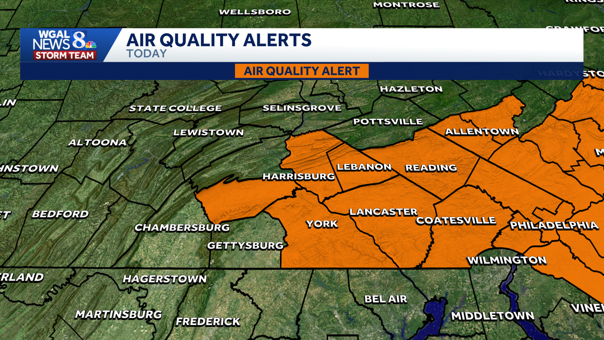
The Pennsylvania Department of Environmental Protection issued a code orange air quality alert for parts of the Susquehanna Valley. Video above: Check out the latest weather forecast from WGAL News 8 Today. The alert is in effect until midnight on Tuesday for the following counties: Cumberland Dauphin Lancaster Lebanon York What ‘Code Orange’ meansAir pollution levels may be unhealthy for sensitive groups, including:ChildrenOlder adultsPeople with asthmaPeople with heart disease or other lung diseasesSafety precautionsLimit strenuous outdoor activity.Reduce outdoor exercise.Sensitive groups should monitor how long they spend outdoors and take breaks as needed.Click here to check your local air quality.Additional advisories aheadAn extreme heat warning was issued from noon on Wednesday to 8 p.m. on Friday for the entire Susquehanna Valley ahead of a prolonged stretch of dangerous heat.The WGAL News 8 Storm Team also declared Wednesday through Friday as Alert Days, meaning the forecast features the threat of extreme, severe, and possibly life-threatening weather. A heat advisory was also issued from 8 p.m. on Friday to 8 p.m. on Saturday, making it an Impact Day, meaning the weather will likely disrupt your normal daily schedule or routine. Did you capture a moment that you would like to share with News 8? Send us your photos or videos at https://www.wgal.com/upload.
The Pennsylvania Department of Environmental Protection issued a code orange air quality alert for parts of the Susquehanna Valley.
Video above: Check out the latest weather forecast from WGAL News 8 Today.
The alert is in effect until midnight on Tuesday for the following counties:
Cumberland Dauphin Lancaster Lebanon York
What ‘Code Orange’ means
Air pollution levels may be unhealthy for sensitive groups, including:
ChildrenOlder adultsPeople with asthmaPeople with heart disease or other lung diseasesSafety precautionsLimit strenuous outdoor activity.Reduce outdoor exercise.Sensitive groups should monitor how long they spend outdoors and take breaks as needed.
Click here to check your local air quality.
Additional advisories ahead
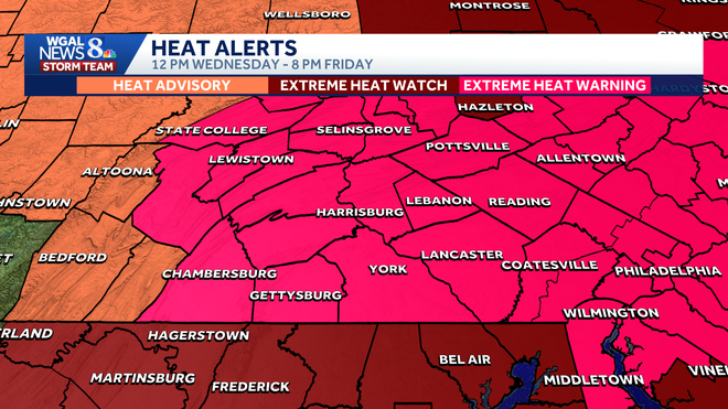
An extreme heat warning was issued from noon on Wednesday to 8 p.m. on Friday for the entire Susquehanna Valley ahead of a prolonged stretch of dangerous heat.
The WGAL News 8 Storm Team also declared Wednesday through Friday as Alert Days, meaning the forecast features the threat of extreme, severe, and possibly life-threatening weather.
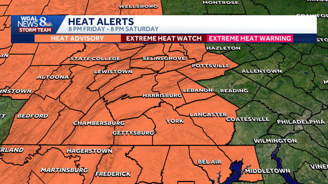
A heat advisory was also issued from 8 p.m. on Friday to 8 p.m. on Saturday, making it an Impact Day, meaning the weather will likely disrupt your normal daily schedule or routine.
Did you capture a moment that you would like to share with News 8? Send us your photos or videos at https://www.wgal.com/upload.