
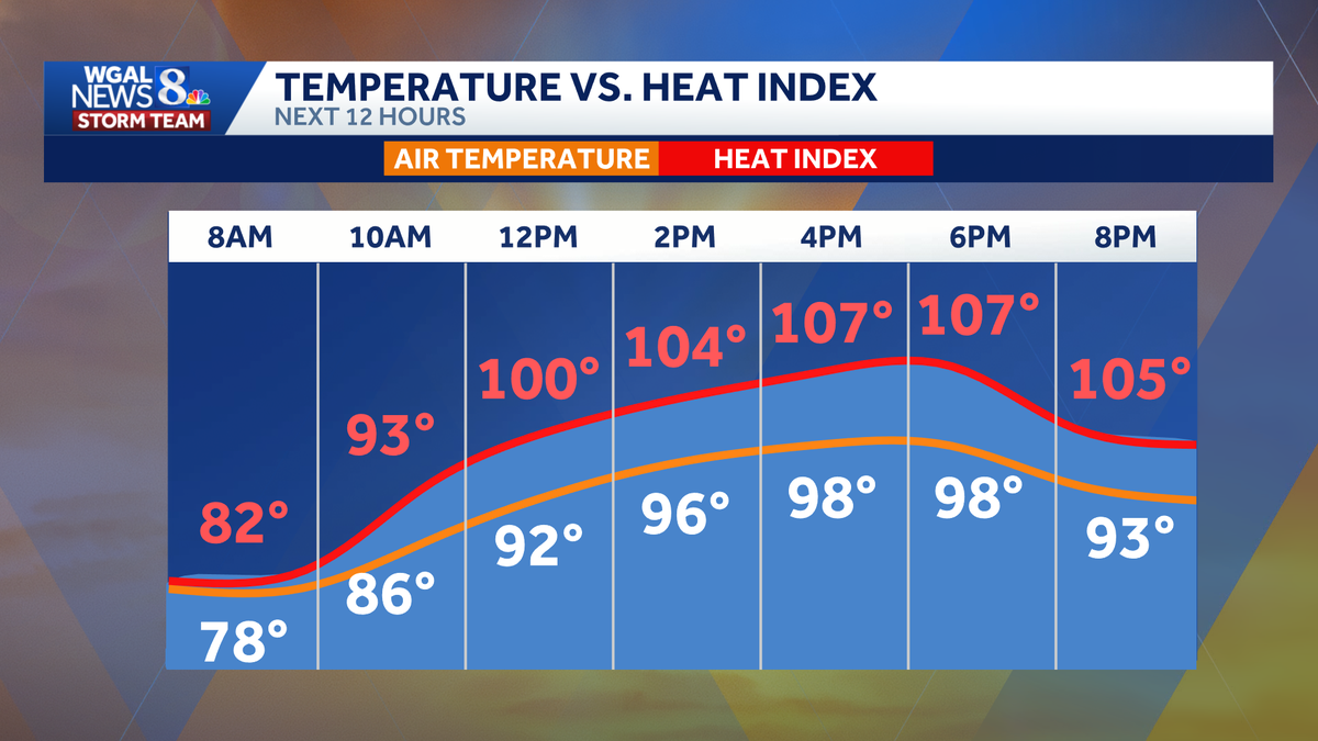
NOW. THE ALERT FORECAST. WGAL NEWS EIGHT STORM TEAM. GOOD MORNING. 645. AND IT’S AN ALERT DAY TODAY, TOMORROW AND FRIDAY BECAUSE WE’RE GOING TO BE NEAR TRIPLE DIGIT HEAT. AND WHEN YOU FACTOR IN TROPICAL HUMIDITY VALUES IT IS GOING TO FEEL LIKE IT’S WELL INTO THE TRIPLE DIGITS. SO TODAY WE COULD ACTUALLY CHALLENGE RECORDS. OUR FORECAST IS 98. THE RECORD STANDS AT 100 SET IN 1931. TOMORROW’S RECORD IS 104. AND THEN THE ALL TIME RECORD HIGH ANNIVERSARY IS ON FRIDAY AT 107. WE’RE NOT GOING TO BEAT THAT ONE. HERE’S A LOOK AT OUR HEAT INDEX FORECAST THOUGH. TODAY, TOMORROW, FRIDAY. NO CHANGE. THE HEAT INDEX 105 TO 110 NOW SATURDAY FOR INDEPENDENCE DAY. MAYBE A SLIGHT BREAK. HEAT NOT AS INTENSE. IT’S STILL GOING TO FEEL LIKE 100 TO 104. I SEE VERY LITTLE CHANGE. THEN FOR THE 4TH OF JULY FORECAST, WE’RE CALLING FOR SULTRY SUNSHINE IN THE MORNING FOR ALL OF YOUR MORNING PARADES AND PLANS AND FESTIVITIES OUTSIDE. IT’S GOING TO WARM QUICKLY. IT WILL BE IN THE 80S, NINE, 10:00 FOR THE AFTERNOON. ON THE FOURTH WE GET TO 96. AND THEN FOR FIREWORKS, WE’RE LOOKING AT 86. BUT WE HAVE TO WATCH OUT FOR JUST A COUPLE OF SHOWERS AND THUNDERSTORMS THAT MAY POP UP IN THE AFTERNOON AND EVENING, SO WE’LL KEEP A WATCHFUL EYE ON THAT AS THE HOURLY DETAILS BECOME AVAILABLE LATER THIS WEEK. TODAY, THOUGH, NEWS EIGHT STORM TEAM FORECAST SAYS THE ALERTS BEGIN THIS AFTERNOON AS TEMPERATURES SOAR. NOW WE’RE GOING TO GET THE MORE TROPICAL HUMIDITY TODAY. SO THAT’S GOING TO MAKE IT FEEL LIKE 105 TO 110. OUR HIGH 98 TONIGHT. WE DON’T COOL OFF MUCH. WE ONLY DROP TO THE UPPER 70S FOR JUST AN HOUR OR TWO. WE’RE GOING TO BE IN THE 80S MOST OF THE NIGHT. AND THE RECORD WARMEST LOW TONIGHT, OFFICIALLY IN HARRISBURG IS 80. TOMORROW, HAZY SUNSHINE, BLAZING HEAT, STILL FEELING LIKE THE TRIPLE DIGITS. AND WE COULD HIT THE LOW 100 TOMORROW AS WELL AS FRIDAY. RIGHT NOW WE HAVE A PAIR OF SEVENS IN HARRISBURG, 73 IN LANCASTER, 75 IN GETTYSBURG. AND THIS IS THE COOLEST PART OF THE DAY. SO IF YOU WANT TO DO YOUR EXERCISE OUTDOORS, THE TIME TO DO IT NOW OR LATE IN THE EVENING, DEW POINT TEMPERATURES, THEY’RE CLIMBING, THEY’RE IN THE 60S IN SOME SPOTS, BUT YOU’LL FEEL THAT MORE INTENSE HUMIDITY TODAY AS OUR DEW POINTS GET UP INTO THE 70S, WHETHER IN IN HEALTH. I WANT TO DIRECT YOUR ATTENTION TO THE UV INDEX. LOOK AT THAT. VERY HIGH. WITH A BURN TIME OF JUST 15 MINUTES. TODAY, OUR AIR QUALITY YESTERDAY WAS ON THE POOR SIDE. BUT TODAY IT’S EXPECTED TO BE MODERATE FOR OZONE. SO WE’LL BE WATCHING THAT CLOSELY. HERE’S THE JET STREAM COMING UP AND AROUND THE GREAT LAKES. SO IT COMES THROUGH THE MIDWEST WAY UP HIGH INTO CANADA AND ACROSS THE NORTHEAST, LEAVING US UNDER THIS HOT HEAT DOME. AND THAT’S EXACTLY WHAT WE’RE GOING TO BE FACED WITH THROUGH THE END OF THIS WEEK. SO MORE OF THE SAME REPEAT FORECAST, DAY AFTER DAY. PREDICTOR WANTS TO POP A STRAY SHOWER TODAY, BUT I DOUBT WE’LL SEE MUCH AT ALL AS WE HEAD INTO TONIGHT. IT’S CLEAR IT’S WARM OVERNIGHT, MUGGY, AND TOMORROW BARELY A CLOUD IN THE SKY. WE’RE GOING TO SEE BLAZING SUNSHINE WITH HIGHS NEAR 100. WE’LL DO THE SAME ON FRIDAY AS THAT DOME OF HEAT MOVES VERY LITTLE. IT’S CENTERED RIGHT OVER US. THERE COULD BE A STRAY SHOWER OR THUNDERSTORM LATER IN THE DAY ON FRIDAY, AND MAYBE A SLIGHTLY BETTER CHANCE ON SATURDAY. BUT IF YOU’RE LOOKING FOR A SCATTERED CHANCE OF SHOWERS AND STORMS, THAT LOOKS TO BE SUNDAY AND MONDAY. NOW, AS THIS DOME OF HEAT BREAKS DOWN, WE GET A FEW MORE DISTURBANCES OVERHEAD AND THAT WILL TRIGGER BETTER CHANCES FOR SOME SHOWERS AND THUNDERSTORMS. BUT NOTICE WE FINALLY GET BACK TO AVERAGE ON MONDAY. AT 88, WE STAY IN THE UPPER 80S. THAT’S TYPI
ALERT DAY | South-central Pennsylvania faces dangerous, near-record heat

Updated: 7:06 AM EDT Jul 1, 2026
A prolonged stretch of dangerous heat arrives in south-central Pennsylvania today, with a combination of near-record temperatures and humidity that will make it feel as hot as 105 to 110 degrees through Friday. What to know An extreme heat warning will be in effect from noon on Wednesday to 8 p.m. on Friday for the entire Susquehanna Valley. The WGAL News 8 Storm Team also declared Wednesday through Friday as Alert Days, meaning the forecast features the threat of extreme, severe, and possibly life-threatening weather. A heat advisory was also issued from 8 p.m. on Friday to 8 p.m. on Saturday, making Saturday an Impact Day, meaning the weather will likely disrupt your normal daily schedule or routine. Dangerous heat The hottest weather is expected from Wednesday through Friday, with highs in the upper 90s to around 100 degrees each day and feels-like temperatures between 105 and 110 degrees. Wednesday: Afternoon highs climb into the upper 90s, possibly nearing 100 degrees.The record is 100 degrees, set in 1931.Humidity levels will rise under mostly sunny skies. Thursday: Temperatures will approach 100 degrees under mostly sunny skies.The record is 104 degrees, set in 1966.Overnight lows will only fall into the upper 70s.Friday: It remains dangerously hot, with highs near 100 degrees.The record is 107 degrees, set in 1966.While a few thunderstorms may develop, widespread rainfall is not expected.Little relief expected at night The heat will not ease much after sunset. Overnight lows from Wednesday through Friday are expected to stay in the mid- to upper 70s, limiting recovery from the daytime heat. Officials say the lack of overnight cooling could increase the risk of heat-related illness, especially for older adults, young children, outdoor workers and people without reliable air conditioning. Triple-digit heat is rare While 100-degree days are possible this week, they remain relatively uncommon for our region. According to Harrisburg’s data: Harrisburg has recorded 63 days of 100 degrees or higher since 1888. Only seven of those days have occurred since 2000. The city’s last 100-degree high was July 16, 2024. The last back-to-back 100-degree highs were July 21-22, 2011, when temperatures reached 101 and 103. Holiday weekend remains hot The hot temperatures will continue into the Independence Day holiday weekend. A heat advisory is in effect until 8 p.m. Saturday, when highs are expected to reach the mid-90s, with heat index values of 100 to 104 degrees. A few evening thunderstorms are possible on Saturday. Some isolated storms could become strong to severe, with the main threats including:Damaging wind gustsBrief heavy rain By Sunday, highs are expected to drop to around 92 degrees, though humid conditions will linger before a more seasonable stretch arrives early next week. Safety precautionsTake frequent breaks if working or spending time outside. Drink plenty of water. Check on neighbors, older adults and vulnerable family members. Make sure pets have water and shade. Never leave children or pets in vehicles, even for short periods of timeFind a cooling station near you.Below: Hot weather tips to beat the heat. Did you capture a moment that you would like to share with News 8? Send us your photos or videos at https://www.wgal.com/upload.
A prolonged stretch of dangerous heat arrives in south-central Pennsylvania today, with a combination of near-record temperatures and humidity that will make it feel as hot as 105 to 110 degrees through Friday.
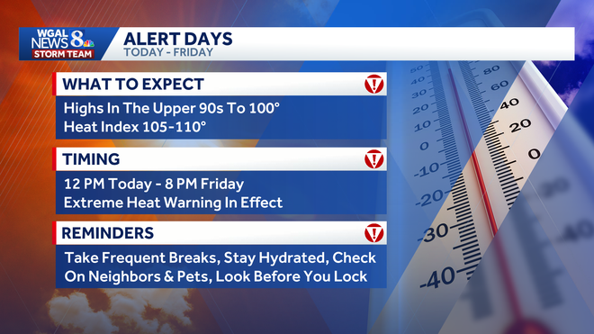
What to know
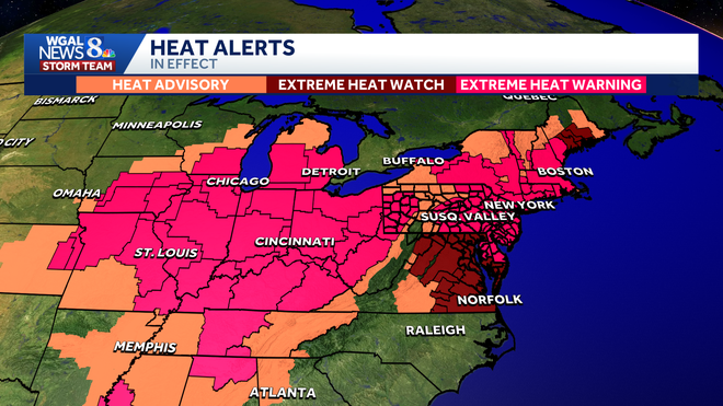
An extreme heat warning will be in effect from noon on Wednesday to 8 p.m. on Friday for the entire Susquehanna Valley.
The WGAL News 8 Storm Team also declared Wednesday through Friday as Alert Days, meaning the forecast features the threat of extreme, severe, and possibly life-threatening weather.
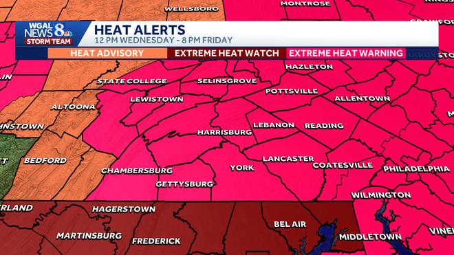
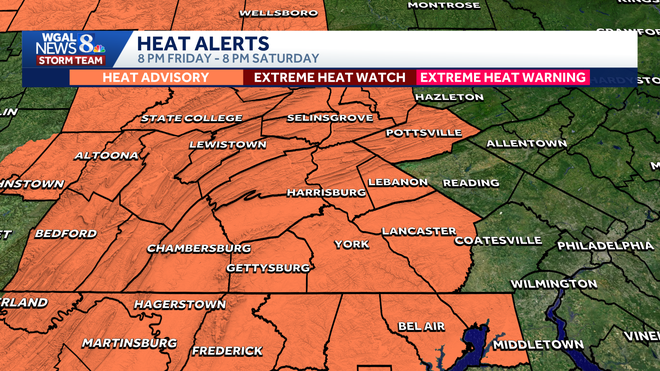
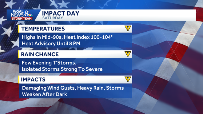
A heat advisory was also issued from 8 p.m. on Friday to 8 p.m. on Saturday, making Saturday an Impact Day, meaning the weather will likely disrupt your normal daily schedule or routine.
Dangerous heat
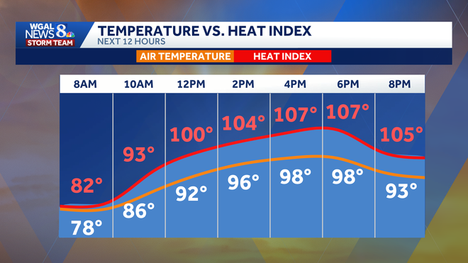
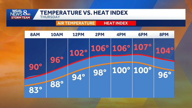
The hottest weather is expected from Wednesday through Friday, with highs in the upper 90s to around 100 degrees each day and feels-like temperatures between 105 and 110 degrees.
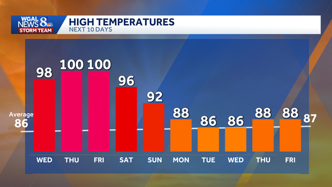
Wednesday:
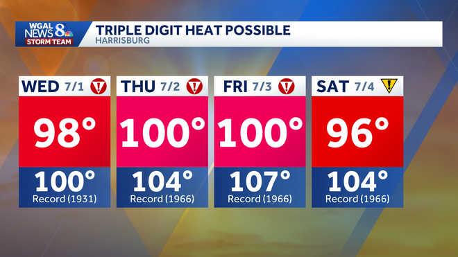
Afternoon highs climb into the upper 90s, possibly nearing 100 degrees.The record is 100 degrees, set in 1931.Humidity levels will rise under mostly sunny skies.
Thursday:
Temperatures will approach 100 degrees under mostly sunny skies.The record is 104 degrees, set in 1966.Overnight lows will only fall into the upper 70s.
Friday:
It remains dangerously hot, with highs near 100 degrees.The record is 107 degrees, set in 1966.While a few thunderstorms may develop, widespread rainfall is not expected.
Little relief expected at night
The heat will not ease much after sunset. Overnight lows from Wednesday through Friday are expected to stay in the mid- to upper 70s, limiting recovery from the daytime heat.
Officials say the lack of overnight cooling could increase the risk of heat-related illness, especially for older adults, young children, outdoor workers and people without reliable air conditioning.
Triple-digit heat is rare
While 100-degree days are possible this week, they remain relatively uncommon for our region.
According to Harrisburg’s data:
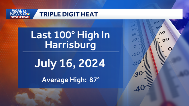
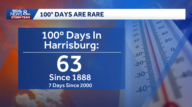
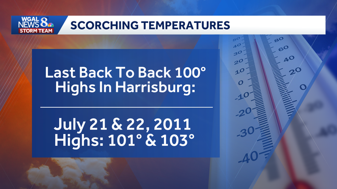
Harrisburg has recorded 63 days of 100 degrees or higher since 1888. Only seven of those days have occurred since 2000. The city’s last 100-degree high was July 16, 2024. The last back-to-back 100-degree highs were July 21-22, 2011, when temperatures reached 101 and 103.
Holiday weekend remains hot
The hot temperatures will continue into the Independence Day holiday weekend.
A heat advisory is in effect until 8 p.m. Saturday, when highs are expected to reach the mid-90s, with heat index values of 100 to 104 degrees.
A few evening thunderstorms are possible on Saturday. Some isolated storms could become strong to severe, with the main threats including:
Damaging wind gustsBrief heavy rain
By Sunday, highs are expected to drop to around 92 degrees, though humid conditions will linger before a more seasonable stretch arrives early next week.
Safety precautionsTake frequent breaks if working or spending time outside. Drink plenty of water. Check on neighbors, older adults and vulnerable family members. Make sure pets have water and shade. Never leave children or pets in vehicles, even for short periods of timeFind a cooling station near you.
Below: Hot weather tips to beat the heat.
Did you capture a moment that you would like to share with News 8? Send us your photos or videos at https://www.wgal.com/upload.