
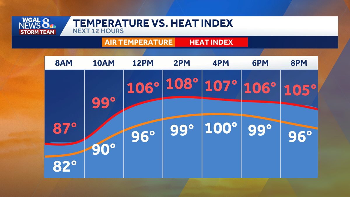
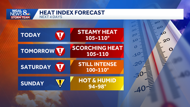
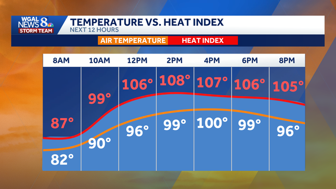
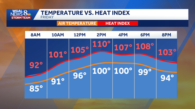
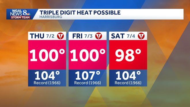
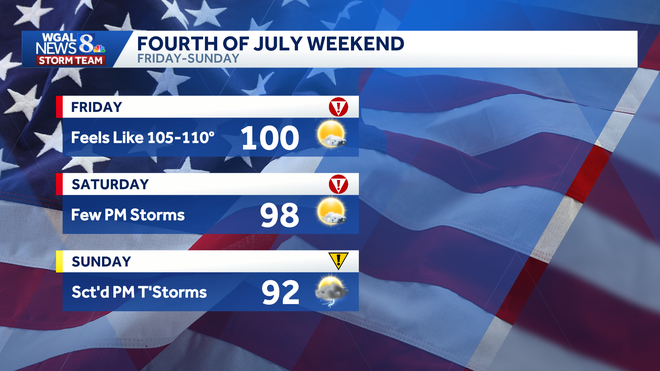
Now the alert day forecast from the WGAL News 8 storm team. Good morning. Let’s talk about this triple digit heat today. We have *** high of 100 degrees. The record 104, set in 1966. 107. That’s the all-time record high. Anniversary is tomorrow. We’re going for 100 degrees, and on Saturday we have 98 for the forecast record being 104. So we’re not going to be getting any records hopefully, but we will be seeing triple digit heat today, tomorrow, and it’ll be very close again on the fourth. Here’s the heat index forecast for today. It’s going to feel like 105 to 110 when you factor in those soupy tropical dew points. Same for tomorrow. Still intense on Saturday. Some areas will cool off just *** little bit, but it feels like temperatures still going to be well into the 100s. And finally Sunday, hot and humid, 94 to 98 for how hot it feels. But we’ll also have the chance for some scattered thunderstorms on Sunday. That seems to be the best bet of the holiday weekend. Here’s your Fourth of July forecast. If you’re out in the morning doing the blanket run, getting ready for the parades, we’ll The sultry sunshine, warm and humid conditions, about 849 for the afternoon. We go with 98 degrees for your high, and then on the fourth, fireworks look good. Couple of thunderstorms may be around. We’ll keep you updated, but it will be warm and stuffy. Here’s *** look at our news 8 storm team forecast for today. It’s an alert day because again we could reach the triple digits, that blazing heat, and it’s going to feel like 105 to 110 degrees for tonight. Clear skies, near record warm. Once again, the record stands at 79, forecasting 78, and then for tomorrow, sizzling sunshine, more of the same here. Feeling like 105 to 110 as the heat wave rolls on. We’ll hit 100 degrees once again tomorrow. Currently it’s 78 in Carlisle. We have 79 degrees in Harrisburg, 75 in Lancaster, and boy is it stuffy. You can kind of cut the air with *** knife. Temperatures for dew points are in the lower 70s, feeling tropical. For our weather and health update today. Mold spores are low. That’s *** change from yesterday. Air quality is still moderate, and the UV index is very high with *** burn time of just 15 minutes. Here’s the storm team live radar network. We have this dome of high pressure we’ve been talking about. It is parked over the eastern half of the country, just giving us hazy, hot and humid conditions as the storm track goes well up into the Great Lakes and over toward the northeast. So dry forecast for us today. Wall to wall blazing sunshine out there, barely *** cloud. In the sky tomorrow we start the day on *** dry note, and it should stay mainly dry throughout the day. Predictor wants to give us *** couple of showers, thunderstorms late in the day, but the chance looks pretty slim. Here we go into the 4th. We’re looking good in the morning. It is dry for most of the afternoon. I think our highest chance for some isolated showers or storms is going to be toward evening, and we’ll be watching those weaken as we approach fireworks time. Sunday’s actually the better chance of the holiday weekend for some scattered showers and Thunderstorms. That chance continues Monday and Tuesday as this dome of heat breaks down and we see more disturbances that could cause some much needed rain chances toward the end of next week. That’s typical July weather. We have highs in the 80s, upper 80s, lows in the upper 60s to near 70 degrees, warm and humid, so we are in the dog days of summer after that. But it does look like Monday and Tuesday could be *** little cooler, Regine. I’m looking forward to those 84s. It’s going to be *** cool down. It’s going to be *** nice break.
ALERT: Extreme heat warning stretches into holiday weekend with triple-digit feels in south-central Pennsylvania

Updated: 6:52 AM EDT Jul 2, 2026
A dangerous stretch of heat is gripping south-central Pennsylvania, with humidity and near-record temperatures pushing the heat index well into the triple digits through Saturday. What to knowAn extreme heat warning remains in effect for the entire Susquehanna Valley until 8 p.m. on Friday, with the warning extended until 8 p.m. on Saturday for Adams, Dauphin, Lancaster, Lebanon and York counties. Cumberland, Franklin, Juniata, Mifflin and Perry counties will be under a heat advisory until 8 p.m. on Saturday. The WGAL News 8 Storm Team has declared Thursday, Friday and Saturday as Alert Days, meaning the forecast features the threat of extreme, severe, and possibly life-threatening weather. Heat index could reach 110 degreesThe dangerous combination of triple-digit high temperatures plus tropical humidity could make it feel like up to 110 degrees. Thursday: Highs near 100 degrees under sunny skies, with a heat index of 105-110The record is 104 degrees, set in 1966. Friday: Highs near 100 degrees, with a heat index of 105-110The record is 107 degrees, set in 1966. Saturday: Highs around 98 degrees, with a heat index of 100-110 Warm nights offer little reliefEven overnight conditions are expected to remain uncomfortable. Temperatures are forecast to fall only to around 78 degrees on Thursday night, close to the record-warm low of 79 degrees, set in 2002. Storm chancesWhile the main story is the heat, isolated storms could develop heading into the weekend. Friday: A few afternoon or evening thunderstorms are possible. Storms could produce damaging wind gusts, though coverage is expected to remain isolated. Saturday: There is a chance for a few afternoon or evening storms, some of which could bring brief heavy rain and damaging wind gusts. By Sunday, highs are expected to drop to around 92 degrees, though humid conditions will linger before a more seasonable stretch arrives early next week. Scattered storms are possible. Triple-digit heat is rareWhile 100-degree days are possible this week, they remain relatively uncommon for our region.According to Harrisburg’s data:Harrisburg has recorded 63 days of 100 degrees or higher since 1888.Only seven of those days have occurred since 2000.The city’s last 100-degree high was July 16, 2024.The last back-to-back 100-degree highs were July 21-22, 2011, when temperatures reached 101 and 103. Safety precautionsTake frequent breaks if working or spending time outside.Drink plenty of water.Check on neighbors, older adults and vulnerable family members.Make sure pets have water and shade.Never leave children or pets in vehicles, even for short periods of timeFind a cooling station near you.Below: Hot weather tips to beat the heat.
A dangerous stretch of heat is gripping south-central Pennsylvania, with humidity and near-record temperatures pushing the heat index well into the triple digits through Saturday.
What to know
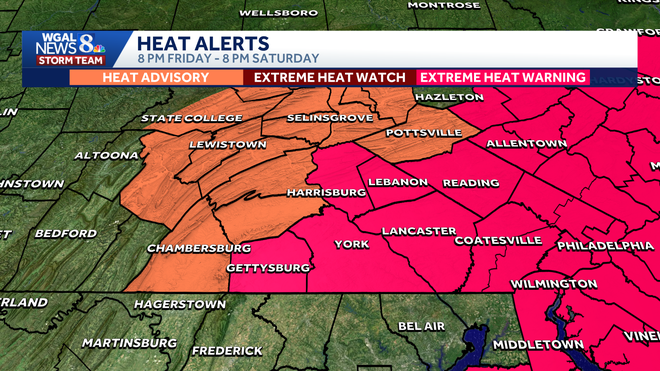
An extreme heat warning remains in effect for the entire Susquehanna Valley until 8 p.m. on Friday, with the warning extended until 8 p.m. on Saturday for Adams, Dauphin, Lancaster, Lebanon and York counties.
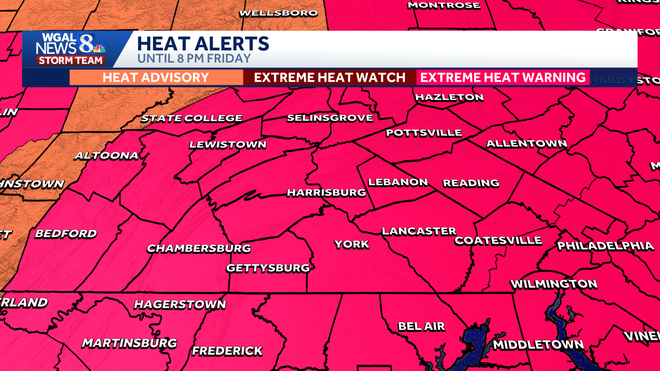
Cumberland, Franklin, Juniata, Mifflin and Perry counties will be under a heat advisory until 8 p.m. on Saturday.
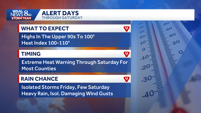
The WGAL News 8 Storm Team has declared Thursday, Friday and Saturday as Alert Days, meaning the forecast features the threat of extreme, severe, and possibly life-threatening weather.
Heat index could reach 110 degrees
The dangerous combination of triple-digit high temperatures plus tropical humidity could make it feel like up to 110 degrees.
Thursday:
Highs near 100 degrees under sunny skies, with a heat index of 105-110The record is 104 degrees, set in 1966.
Friday:
Highs near 100 degrees, with a heat index of 105-110The record is 107 degrees, set in 1966.
Saturday:
Highs around 98 degrees, with a heat index of 100-110
Warm nights offer little relief
Even overnight conditions are expected to remain uncomfortable.
Temperatures are forecast to fall only to around 78 degrees on Thursday night, close to the record-warm low of 79 degrees, set in 2002.
Storm chances
While the main story is the heat, isolated storms could develop heading into the weekend.
Friday: A few afternoon or evening thunderstorms are possible. Storms could produce damaging wind gusts, though coverage is expected to remain isolated.
Saturday: There is a chance for a few afternoon or evening storms, some of which could bring brief heavy rain and damaging wind gusts.
By Sunday, highs are expected to drop to around 92 degrees, though humid conditions will linger before a more seasonable stretch arrives early next week. Scattered storms are possible.
Triple-digit heat is rare
While 100-degree days are possible this week, they remain relatively uncommon for our region.
According to Harrisburg’s data:
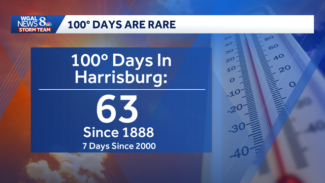
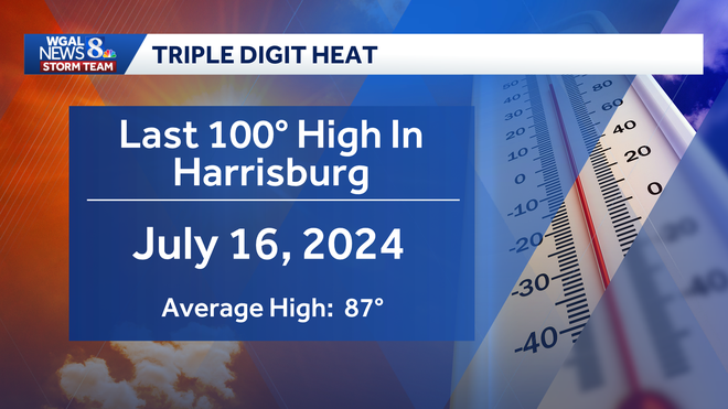
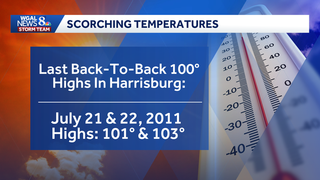
Harrisburg has recorded 63 days of 100 degrees or higher since 1888.Only seven of those days have occurred since 2000.The city’s last 100-degree high was July 16, 2024.The last back-to-back 100-degree highs were July 21-22, 2011, when temperatures reached 101 and 103.
Safety precautionsTake frequent breaks if working or spending time outside.Drink plenty of water.Check on neighbors, older adults and vulnerable family members.Make sure pets have water and shade.Never leave children or pets in vehicles, even for short periods of timeFind a cooling station near you.
Below: Hot weather tips to beat the heat.