
The intense heat wave eases this holiday weekend. It will still feel like the mid-90s or hotter. We are also monitoring thunderstorm chances with heavy rain and a rush of strong winds. The timing of the storms could spell trouble for some communities’ fireworks displays.Severe Thunderstorm Warning A Severe Thunderstorm Warning has been issued in Western Pennsylvania on Saturday. The National Weather Service said the following counties are under the warning until 7:15 p.m.: Fayette, Washington, and Westmoreland.City of Pittsburgh officials are advising those outside to seek shelter and move indoors if possible due to the storms moving into the area. As of 6:15 p.m., Independence Day programs have been temporarily suspended. Officials said event updates will be made on social media as conditions change. Shelter locations include the Wyndham Grand Pittsburgh (Downtown), the United Steelworkers Building garage, and Acrisure Stadium. More: Read the weather alert for your countyInteractive radar: Track storms in your areaLearn how to enable automatic weather alerts on the WTAE app WATCH PREVIOUS WEATHERCAST IN THE PLAYFINDER ABOVE Flash Flood Warning A Flash Flood Warning is in place for parts of Western Pennsylvania Saturday. The National Weather Service says the warning is in place for the following counties until 9:30 p.m.: Fayette, Westmoreland, and Washington. Some locations that will experience flash flooding include… Washington, Monessen, California, Donora, Mount Pleasant, Scottdale, Monongahela, Charleroi, West Newton, Bentleyville, East Washington, New Stanton, Perryopolis, North Belle Vernon, Wickerham Manor-Fisher, Baidland, Calumet-Norvelt, North Charleroi and Speers.Severe Storm Watch Multiple counties in the area are also under a Severe Thunderstorm Watch on Saturday. The watch is in place for the following counties until 9 p.m.: Allegheny, Armstrong, Butler, Beaver, Clairton, Fayette, Greene, Indiana, Lawrence, Mercer, Washington, and Westmoreland counties. Intense Heat to soon End The intense heat wave eases this holiday weekend. It will still feel like the mid 90s or hotter. We are also monitoring thunderstorm chances with heavy rain and a rush of strong winds. The heat alerts are set to expire at 8 p.m. Allegheny, Greene, Washington along with the lowlands of Fayette, Westmoreland and Monongalia counties remain under an Extreme Heat Warning. It is a Heat Advisory for Armstrong, Beaver, Butler, Lawrence and the lowlands of Indiana counties.Storms that develop Saturday afternoon and evening will produce strong winds, frequent lightning, and heavy downpours. The severe threat will come to an end by 9 p.m. with most locations dry by the time fireworks go off at 9:35.Impact Day Sunday The coverage of unsettled weather ramps up Sunday, but the activity won’t be as intense. Strong storms will stay east of the Pittsburgh area with rain and storms through most of the afternoon and evening. Sunday is an Impact Day.Returning to “normal” next week The “dog days of summer” are upon us, but it doesn’t need to be this hot so soon. Highs slide back into the 80s. A major, noticeable difference will be the drop in humidity. We will monitor chances for a few more thunderstorms and rain chances, especially late in next week.TONIGHT: Storms early then partly cloudy. Low: 70°.SUNDAY – Impact Day. Hot and humid with afternoon storms. High: 87°, low: 70°.MONDAY: Mostly cloudy with scattered showers. High: 81°, low: 68°.TUESDAY: Morning showers then mostly cloudy. High: 80°, low: 66°.
The intense heat wave eases this holiday weekend. It will still feel like the mid-90s or hotter. We are also monitoring thunderstorm chances with heavy rain and a rush of strong winds. The timing of the storms could spell trouble for some communities’ fireworks displays.
Severe Thunderstorm Warning
A Severe Thunderstorm Warning has been issued in Western Pennsylvania on Saturday.
The National Weather Service said the following counties are under the warning until 7:15 p.m.: Fayette, Washington, and Westmoreland.
City of Pittsburgh officials are advising those outside to seek shelter and move indoors if possible due to the storms moving into the area.
As of 6:15 p.m., Independence Day programs have been temporarily suspended.
This content is imported from Twitter.
You may be able to find the same content in another format, or you may be able to find more information, at their web site.
A weather update on Pittsburgh’s Independence Day celebrations. We’re temporarily suspending programs & will provide more updates as we monitor the weather. pic.twitter.com/pGz9akMaAi
— City of Pittsburgh (@Pittsburgh) July 4, 2026
Officials said event updates will be made on social media as conditions change.
Shelter locations include the Wyndham Grand Pittsburgh (Downtown), the United Steelworkers Building garage, and Acrisure Stadium.
WATCH PREVIOUS WEATHERCAST IN THE PLAYFINDER ABOVE
Flash Flood Warning
A Flash Flood Warning is in place for parts of Western Pennsylvania Saturday.
The National Weather Service says the warning is in place for the following counties until 9:30 p.m.: Fayette, Westmoreland, and Washington.
Some locations that will experience flash flooding include… Washington, Monessen, California, Donora, Mount Pleasant, Scottdale, Monongahela, Charleroi, West Newton, Bentleyville, East Washington, New Stanton, Perryopolis, North Belle Vernon, Wickerham Manor-Fisher, Baidland, Calumet-Norvelt, North Charleroi and Speers.
Severe Storm Watch
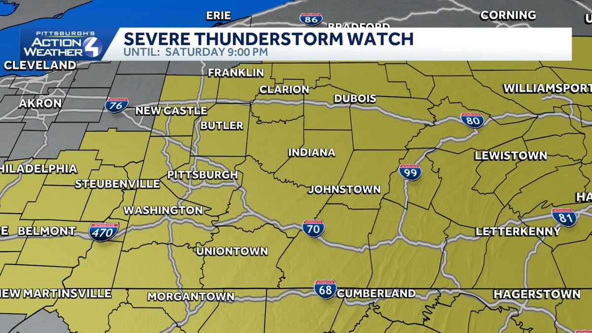
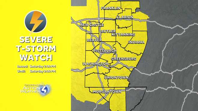
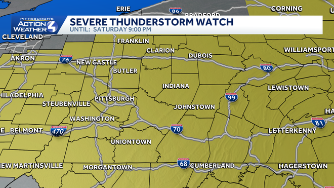
Multiple counties in the area are also under a Severe Thunderstorm Watch on Saturday.
The watch is in place for the following counties until 9 p.m.: Allegheny, Armstrong, Butler, Beaver, Clairton, Fayette, Greene, Indiana, Lawrence, Mercer, Washington, and Westmoreland counties.
Intense Heat to soon End
The intense heat wave eases this holiday weekend. It will still feel like the mid 90s or hotter. We are also monitoring thunderstorm chances with heavy rain and a rush of strong winds.
The heat alerts are set to expire at 8 p.m. Allegheny, Greene, Washington along with the lowlands of Fayette, Westmoreland and Monongalia counties remain under an Extreme Heat Warning. It is a Heat Advisory for Armstrong, Beaver, Butler, Lawrence and the lowlands of Indiana counties.
Storms that develop Saturday afternoon and evening will produce strong winds, frequent lightning, and heavy downpours. The severe threat will come to an end by 9 p.m. with most locations dry by the time fireworks go off at 9:35.
Impact Day Sunday
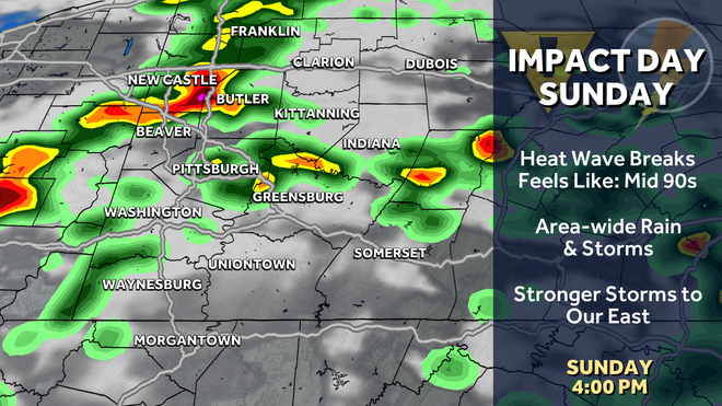
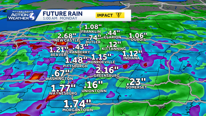
The coverage of unsettled weather ramps up Sunday, but the activity won’t be as intense. Strong storms will stay east of the Pittsburgh area with rain and storms through most of the afternoon and evening. Sunday is an Impact Day.
Returning to “normal” next week
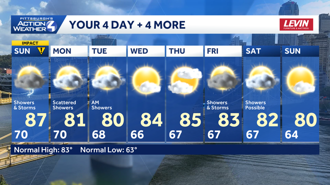
The “dog days of summer” are upon us, but it doesn’t need to be this hot so soon. Highs slide back into the 80s. A major, noticeable difference will be the drop in humidity. We will monitor chances for a few more thunderstorms and rain chances, especially late in next week.
TONIGHT: Storms early then partly cloudy. Low: 70°.
SUNDAY – Impact Day. Hot and humid with afternoon storms. High: 87°, low: 70°.
MONDAY: Mostly cloudy with scattered showers. High: 81°, low: 68°.
TUESDAY: Morning showers then mostly cloudy. High: 80°, low: 66°.