Flood watch and storm risk begin Sunday in South-Central Pennsylvania
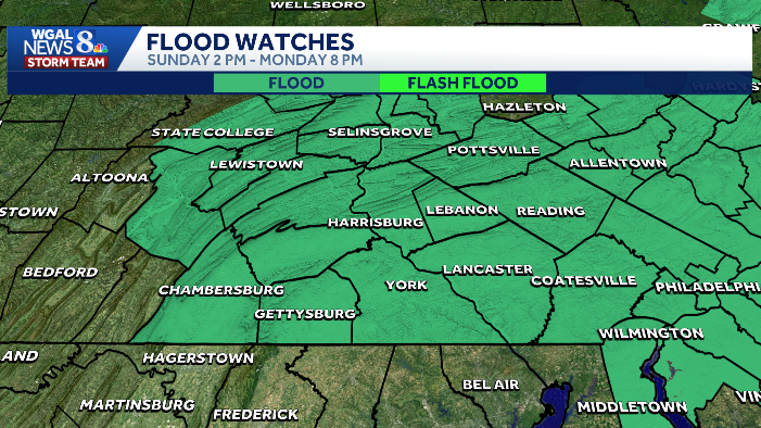
Flood Watch is in effect from 2 p.m. Sunday through 8 p.m. Monday
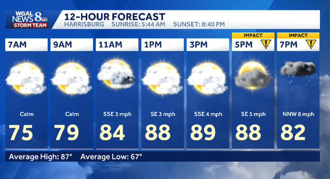
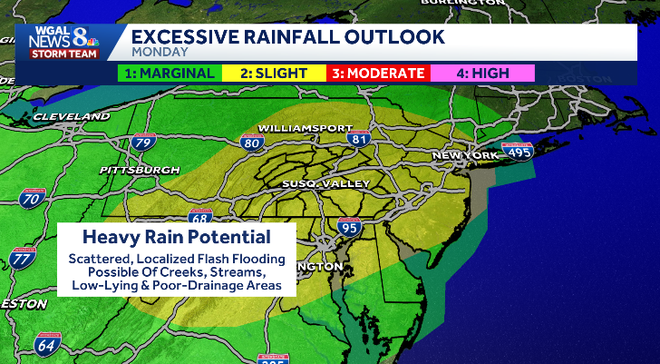
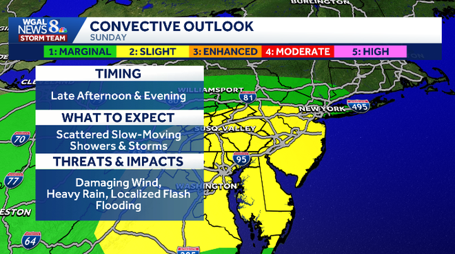
As we take *** look at the weather headlines, there will be another round of storms that move in late afternoon into the evening hours. They could be on the strong to severe side, and we also have an elevated flood risk, so it is an impact day because of that. Uh, plenty of dry hours though to get out and enjoy or clean up unfortunately from those storms last night. Now we do have *** couple cooler days ahead as we head back into the work week. Temperatures will drop back to right around 80 degrees for both Monday and Tuesday and then we head back up to seasonable averages mid to late week with more storm chances. We are outlooked. This is the convective outlook from the storm Prediction Center. You can see we are highlighted in *** slight risk, which is *** 2 on *** scale of 1 to 5. Uh, the timing again late afternoon in our western counties. It’ll take *** little bit longer for our southern and eastern counties to see these storms, more towards the evening hours. Scattered slow moving showers and storms. Will be possible. Damaging winds. Primary threat heavy rain also *** primary threat. Localized flash flooding will be possible, and there may even be some hail. Now *** flood watch will go into effect at 2 p.m. today until 8:00 p.m. Monday because the storm shower chances and storm chances will continue into tomorrow. In fact, tomorrow has *** slightly higher chance for seeing some heavy potential rainfall, scattered localized flash flooding. Creeks, streams, low lying areas, poor drainage areas. So just keep that in mind as we head through the next 24 hours. For today though, we’ve got *** little bit of sunshine out there right now, *** lot of cloud cover. I can’t rule out an isolated shower later this morning, but most of the day is dry, as I mentioned. Temperatures will climb into the upper 80s to near 90 degrees. Storms will develop after 4 o’clock in our western counties. It’ll take *** little longer again for those eastern counties, uh, to see the storms moving in. Scattered storms. That’s going to be the best chance is this evening for seeing those strong to severe storms and the heavy downpours. Temperatures right around 80 degrees. Um, overnight tonight we could have *** few showers lingering, maybe even *** rumble of thunder. Otherwise it’s muggy with some patchy fog, temperatures in the low 70s, and tomorrow scattered showers and storms in the afternoon and the evening. We are not outlooked for severe weather tomorrow as of right now. However, the flood threat is elevated as I just showed you. That’s why. Tomorrow is also an impact day. Temperatures though much cooler, although it’ll still be humid with highs around 80. Right now we’re sitting at 72 in Carlisle, 73 in Gettysburg, York’s at 70, along with Lebanon and Lewistown. We have low 70s in Harrisburg. Dew points are in the upper 60s and low 70s, so it is feeling quite soupy outside. And look at these numbers. They climb into the low 70s, even mid 70s as we head through the afternoon and evening hours. So no relief from the humidity, uh, for today. We’ve got *** stationary boundary literally right over the area and it’s going to stay pretty close to us for the next 24 hours, but this is going to be where we see these showers and storms firing as some upper level energy comes through. Unfortunately, the winds in the upper levels not very strong at all, so these storms will be slow moving, and that’s what gives us the potential for these heavier downpours. Then things start to quiet down overnight into tomorrow, but we do have another round in the afternoon, the evening, and again. Not severe storms tomorrow, but the rain could lead to the possibility of some flooding in some areas. And then Tuesday we’ll have more shower and storm chances, although our system is pulling away, so I do expect *** drying trend. Rainfall potential through tomorrow evening. We could see some areas, uh, picking up close to 2 inches or more if you get in under one of these. Thunderstorms with the torrential rain. 10 day forecast shows once we get beyond Tuesday, temperatures start to climb back up to more seasonable averages. Upper 80s by Thursday and Friday. Still some storm chances each day, but no washouts. And then next weekend, mid 80s with the possibility of some storms, still pinning trying to pinpoint which day has the best chance.
Flood watch and storm risk begin Sunday in South-Central Pennsylvania
Flood Watch is in effect from 2 p.m. Sunday through 8 p.m. Monday

Updated: 9:06 AM EDT Jul 5, 2026
A Flood Watch is in effect from 2 p.m. Sunday through 8 p.m. Monday for South-Central Pennsylvania, with multiple rounds of slow-moving thunderstorms expected to bring heavy rain, flooding concerns, and a chance for severe weather.Sunday: Heavy rain and severe storm riskA Flood Watch starts at 2 p.m. Sunday and continues until 8 p.m. Monday.The Storm Prediction Center has placed the entire Susquehanna Valley in a Slight Risk for severe storms.Storms may produce:Damaging windLarge hailRainfall rates over 2 inches per hourHighs will reach the mid to upper 80s, near 90, with very humid conditions Sunday night: Storms continueThe severe threat ends tonight, but showers and thunderstorms remain likely.Lows will settle into the low 70s.Foggy areas and muggy conditions are possible. Monday: Cooler, but flooding risk continuesTemperatures drop back to near 80 degrees.Showers may develop early, followed by scattered showers and storms in the afternoon.Severe weather is not currently expected, but excessive runoff and flooding remain a concern.Tuesday and beyond: Unsettled, then a bit drierTuesday stays unsettled with more showers and a rumble or two.Highs will be around 80 degrees.The rest of the week trends drier, though a few showers and storms may still pop up.Highs return to the mid and upper 80s.Another system may bring showers and storms next weekend, but timing remains uncertain.
A Flood Watch is in effect from 2 p.m. Sunday through 8 p.m. Monday for South-Central Pennsylvania, with multiple rounds of slow-moving thunderstorms expected to bring heavy rain, flooding concerns, and a chance for severe weather.
Sunday: Heavy rain and severe storm riskA Flood Watch starts at 2 p.m. Sunday and continues until 8 p.m. Monday.The Storm Prediction Center has placed the entire Susquehanna Valley in a Slight Risk for severe storms.Storms may produce:Damaging windLarge hailRainfall rates over 2 inches per hourHighs will reach the mid to upper 80s, near 90, with very humid conditions
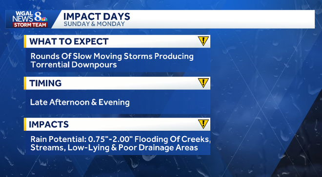
Sunday night: Storms continueThe severe threat ends tonight, but showers and thunderstorms remain likely.Lows will settle into the low 70s.Foggy areas and muggy conditions are possible.
Monday: Cooler, but flooding risk continues
Temperatures drop back to near 80 degrees.Showers may develop early, followed by scattered showers and storms in the afternoon.Severe weather is not currently expected, but excessive runoff and flooding remain a concern.Tuesday and beyond: Unsettled, then a bit drierTuesday stays unsettled with more showers and a rumble or two.Highs will be around 80 degrees.The rest of the week trends drier, though a few showers and storms may still pop up.Highs return to the mid and upper 80s.Another system may bring showers and storms next weekend, but timing remains uncertain.