
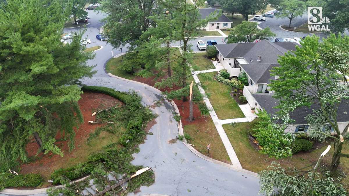
WGAL viewers are sharing photos and videos showing damage caused by storms that swept across South-Central Pennsylvania on the Fourth of July. We’ve posted some of those photos and videos on this page and will continue to post updates as more come in.SHARE | If you have photos or videos you’d like to share, go here.UPDATE | The threat of severe weather continues Sunday. We’ve posted those details below. Flood watch in effect | Severe storm threat buildsA Flood Watch begins at 2 p.m. today and lasts through Monday at 8 p.m. for South-Central Pennsylvania, where repeated rounds of slow-moving thunderstorms could bring heavy rain, flooding, and a risk for severe weather.Heavy rain and flooding concernsMultiple rounds of thunderstorms are expected from later today into MondayRainfall rates could exceed 2 inches per hourStorms may train or linger over the same areasFlooding is possible in:creeks and streamslow-lying spotspoor drainage areasurban locationsSevere weather risk todayThe Storm Prediction Center has placed the entire Susquehanna Valley in a Slight Risk for severe storms today, which is a 2 out of 5.Main threats:damaging windlarge hailHigh temperatures will reach the mid and upper 80s to near 90Conditions will remain humidTonight and MondayThe severe threat ends tonight, but showers and thunderstorms will continue.Lows will settle in the low 70sFoggy spots are possibleConditions will stay muggy overnight and into MondayCheck live conditions around the ValleySOUTH-CENTRAL PA WEATHER RESOURCES: INTERACTIVE RADAR | ACTIVE WEATHER ALERTS | CURRENT CONDITIONS | HOURLY FORECAST | 10-DAY FORECAST | WEEKEND FORECAST | MAP ROOM | DOWNLOAD THE APP | WEATHER EMAILS
WGAL viewers are sharing photos and videos showing damage caused by storms that swept across South-Central Pennsylvania on the Fourth of July. We’ve posted some of those photos and videos on this page and will continue to post updates as more come in.
SHARE | If you have photos or videos you’d like to share, go here.
UPDATE | The threat of severe weather continues Sunday. We’ve posted those details below.
2 of 17
Manheim Township off Euclid Drive
PHOTO: uLocal
3 of 17
East Frederick in Lancaster City.
PHOTO: uLocal
4 of 17
East Earl Township
PHOTO: WGAL
5 of 17
East Earl Township
PHOTO: WGAL
6 of 17
Route 322 between Ephrata and Hinkletown
PHOTO: uLocal
7 of 17
Hillcrest Road and Tenth Street in Akron
PHOTO: uLocal
8 of 17
Hillcrest Road and Tenth Street in Akron
PHOTO: uLocal
9 of 17
Hillcrest Road and Tenth Street in Akron
PHOTO: uLocal
10 of 17
Larchmont Lane, Manheim Township
PHOTO: uLocal
11 of 17
Larchmont Lane, Manheim Township
PHOTO: uLocal
12 of 17
Park City Center, Lancaster
PHOTO: WGAL
13 of 17
East York
PHOTO: uLocal
14 of 17
East York
PHOTO: uLocal
15 of 17
Butter Road, Manheim Township
PHOTO: uLocal
16 of 17
Kissel Hill Commons, Lititz
PHOTO: uLocal
17 of 17
Kissel Hill Commons, Lititz
PHOTO: uLocal
Flood watch in effect | Severe storm threat builds
A Flood Watch begins at 2 p.m. today and lasts through Monday at 8 p.m. for South-Central Pennsylvania, where repeated rounds of slow-moving thunderstorms could bring heavy rain, flooding, and a risk for severe weather.
Heavy rain and flooding concernsMultiple rounds of thunderstorms are expected from later today into MondayRainfall rates could exceed 2 inches per hourStorms may train or linger over the same areasFlooding is possible in:creeks and streamslow-lying spotspoor drainage areasurban locationsSevere weather risk today
The Storm Prediction Center has placed the entire Susquehanna Valley in a Slight Risk for severe storms today, which is a 2 out of 5.
Main threats:High temperatures will reach the mid and upper 80s to near 90Conditions will remain humidTonight and Monday
The severe threat ends tonight, but showers and thunderstorms will continue.
Lows will settle in the low 70sFoggy spots are possibleConditions will stay muggy overnight and into MondayCheck live conditions around the Valley
SOUTH-CENTRAL PA WEATHER RESOURCES: INTERACTIVE RADAR | ACTIVE WEATHER ALERTS | CURRENT CONDITIONS | HOURLY FORECAST | 10-DAY FORECAST | WEEKEND FORECAST | MAP ROOM | DOWNLOAD THE APP | WEATHER EMAILS