
IMPACT: Storms return Thursday in south-central Pennsylvania with risk of damaging winds, heavy downpours
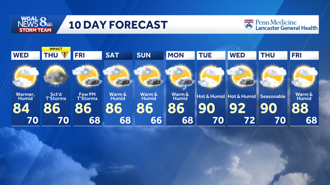
NOW THE WGAL NEWS EIGHT STORM TEAM FORECAST WITH CHIEF METEOROLOGIST CHRISTINE FERREIRA. GOOD MORNING. IT IS 6.46 STORM TEAM LIVE RADAR NETWORK PICKING UP JUST A TINY LINE OF SHOWERS ROLLING RIGHT THROUGH FRANKLIN COUNTY. IT’S THE ONLY SPOT SEEING SOME RAIN THIS MORNING JUST SOUTH OF CHAMBERSBURG TOWARD WAYNESBORO, GREENCASTLE, JUST NORTH OF YOU. THAT’S WHERE WE’RE SEEING THE SHOWERS. IF YOU’RE DRIVING, I-81 PROBABLY HIT THE WINDSHIELD WIPERS GOING JUST A COUPLE OF TIMES AS YOU DRIVE THROUGH THAT LITTLE LINE. NOW, TOMORROW WE DO HAVE A BETTER CHANCE OF SOME SCATTERED SHOWERS AND THUNDERSTORMS TODAY, MAINLY DRY, BUT TOMORROW IT’S EASTERN COUNTIES THAT ARE UNDER A MARGINAL RISK OF SEVERE WEATHER. SO THAT’S A VERY LOW RISK FOR ANY ISOLATED STORMS THAT MAY PRODUCE DAMAGING WIND GUSTS AS WELL AS BRIEF HEAVY RAINFALL. I THINK TOMORROW MORNING THERE WILL BE A FEW SHOWERS AROUND, BUT A BETTER CHANCE OF THOSE SCATTERED THUNDERSTORMS IN THE AFTERNOON AND EVENING. NOT A GUARANTEE THAT YOU GET THE RAIN TOMORROW. BUT IF YOU DO, ISOLATED STORMS MAY BE STRONG OR SEVERE. SO THAT’S WHAT WE’RE GOING TO BE WATCHING OUT FOR, MAINLY BETWEEN 2 P.M. AND ABOUT 10 P.M. TOMORROW. TEAM FORECAST IS TRENDING BRIGHTER. IT’S NICE TO SEE THE SUNSHINE AGAIN IN SOME SPOTS THIS MORNING. THE CLOUDS ARE STARTING TO CLEAR. IT’S STICKY OUT THERE. IT’S NOT ALL THAT BAD AS FAR AS HUMIDITY IS CONCERNED, BUT THE HUMIDITY WILL BE COMING BACK THIS AFTERNOON. OUR HIGH TODAY 84 DEGREES TURNING MORE HUMID LATER. JUST A FEW CLOUDS THIS EVENING. TEMPERATURES IN THE LOW 80S. FOR TONIGHT WE HAVE 68 TO 72. MOSTLY CLOUDY. A STRAY SHOWER. WE’LL KEEP THE MUGGINESS AROUND AND TOMORROW A COUPLE OF MORNING SHOWERS, FOLLOWED BY THAT SCATTERED ACTIVITY IN THE AFTERNOON. IMPACTS DO INCLUDE THE DAMAGING WIND GUSTS AND HEAVY RAIN, BUT NOT ANYWHERE NEAR AS STRONG AS WHAT WE SAW OVER THE WEEKEND. HERE’S A LOOK AT YOUR TEMPERATURES AT 70 DEGREES IN LEWISTOWN. 69 IN YORK, 67 DEGREES IN LANCASTER. GOOD MORNING HARRISBURG. YOU HAVE 70 RIGHT ON THE NOSE. AND CHECK OUT YOUR DEW .63. NOT ALL THAT BAD. WE DO HAVE SOME NORTHEASTERLY WINDS COMING IN THIS MORNING, HELPING TO LOWER THE HUMIDITY EVER SO SLIGHTLY. SO WEATHER HEALTH UPDATE TODAY OUR RAGWEED POLLEN LEVELS ARE MODERATE AIR QUALITY MODERATE AS WELL. UV INDEX HIGHER THAN YESTERDAY. A BURN TIME OF 35 MINUTES WITH MORE SUN. SO RIGHT NOW HIGH PRESSURE IS TRYING TO BUILD IN FROM THE NORTHEAST, ERODING THE CLOUD COVER OVERHEAD. AND ASIDE FROM A STRAY SHOWER IN SOUTHWESTERN COUNTIES, WE SHOULD BE DRY TODAY. SO A MAINLY DRY DAY FOR MUCH OF THE AREA. YOU SEE THE BIG BLUE H BUILDING SOUTH, HELPING TO GET RID OF THAT CLOUD COVER AND BRINGING YOU A PLEASANT WEDNESDAY. NOW TONIGHT, CLOUDS COME RIGHT BACK IN. HIGH PRESSURE HITS THE ROAD AND TOMORROW WE HAVE THE CHANCE OF THOSE SCATTERED SHOWERS AND STORMS. I DO FAVOR AREAS TO THE SOUTH, OFF TO THE EAST FOR STRONGER EFFECTS FROM THOSE STORMS TOMORROW. BY THE TIME WE HIT FRIDAY, ANOTHER ROUND OF SHOWERS AND THUNDERSTORMS WITH A COLD FRONT DROPPING IN THAT WILL PRODUCE A ROUND OF SHOWERS IN THE MORNING, MAYBE A FEW THUNDERSTORMS IN THE AFTERNOON, BUT RIGHT NOW WE ARE NOT. OUTLOOK FOR SEVERE WEATHER ON FRIDAY FOR THE WEEKEND IT IS LOOKING GOOD. TEMPERATURES WILL BE NEAR AVERAGE. TYPICAL FOR JULY MID TO UPPER 80S. WE HAVE THE CHANCE OF A SHOWER OR THUNDERSTORM SATURDAY OR SUNDAY, BUT THE CHANCES PRETTY LOW NEXT WEEK ALSO LOOKS LIKE A MAINLY DRY STRETCH FOR US. AND LOOK AT THOSE 90S COMING BACK. WE COULD HAVE A LITTLE HEAT WAVE ON OUR HANDS. TUESDAY, WEDNESDAY, THURSDAY. NOT AS HOT, NOT AS IMPRESSIVE AS LAST
IMPACT: Storms return Thursday in south-central Pennsylvania with risk of damaging winds, heavy downpours

Updated: 10:25 AM EDT Jul 8, 2026
Storm chances are expected to return on Thursday in south-central Pennsylvania. The WGAL News 8 Storm Team has declared Thursday an Impact Day, meaning the weather will likely disrupt your normal daily schedule or routine. Timing A few showers are possible in the morning before scattered showers and thunderstorms are expected to develop in the afternoon and evening. The highest chance for storms is between 2 p.m. and 10 p.m. It will be warm and humid, with highs in the mid-80s. Below: Swipe through the predicted radar for Thursday’s storms. Main threats While Thursday’s storms are not expected to be as intense as the severe weather seen over the holiday weekend, a few isolated storms could produce: Isolated damaging wind gusts Brief heavy rain The risk for flash flooding is low, and large hail and tornadoes are not expected at this time. Marginal risk The following counties are in a marginal risk (level 1/5) for severe weather: Lebanon Lancaster York Adams Southern Dauphin Southeastern Franklin Looking ahead Friday will be humid with highs in the mid-80s and a few afternoon showers and thunderstorms as a cold front passes. Severe weather and excessive rainfall are not expected at this time. Next week starts in the mid-80s Monday before heat builds Tuesday through Thursday, with highs reaching the low 90s. Rain chances stay low overall, with only a slight chance for a few thunderstorms Wednesday. Did you capture a moment that you would like to share with News 8? Send us your photos or videos at https://www.wgal.com/upload.
Storm chances are expected to return on Thursday in south-central Pennsylvania.
The WGAL News 8 Storm Team has declared Thursday an Impact Day, meaning the weather will likely disrupt your normal daily schedule or routine.
Timing
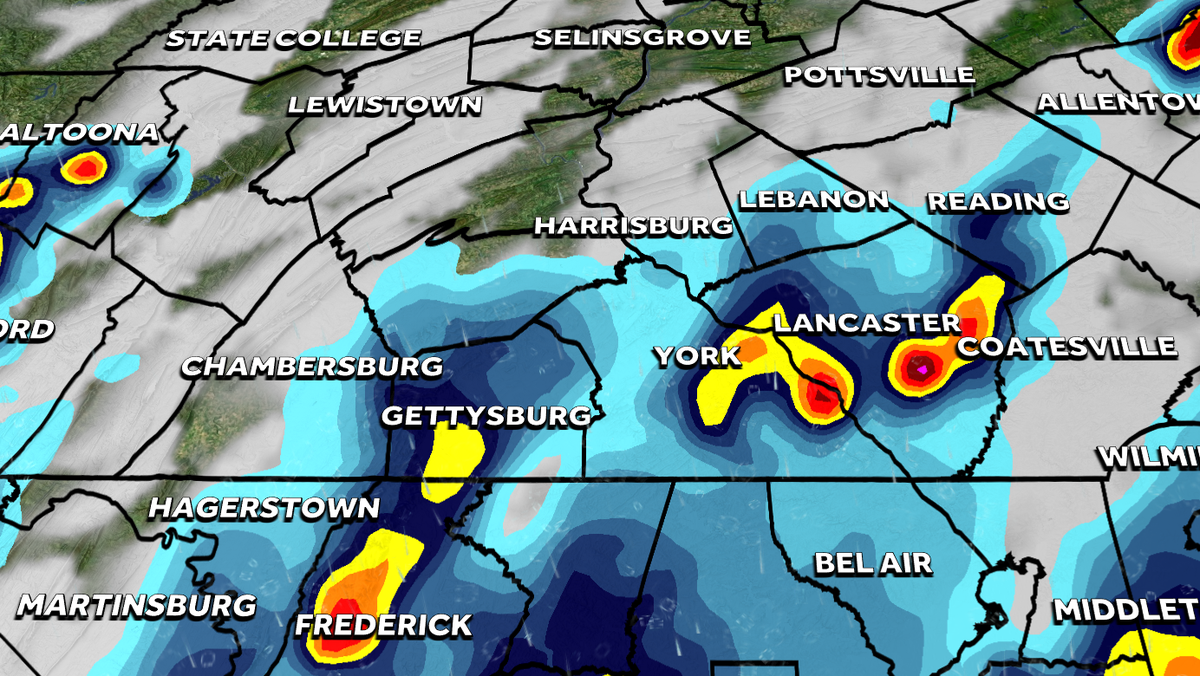
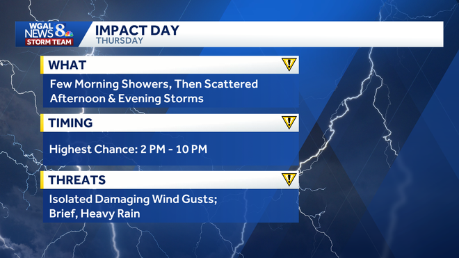
A few showers are possible in the morning before scattered showers and thunderstorms are expected to develop in the afternoon and evening.
The highest chance for storms is between 2 p.m. and 10 p.m.
It will be warm and humid, with highs in the mid-80s.
Below: Swipe through the predicted radar for Thursday’s storms.
Main threats
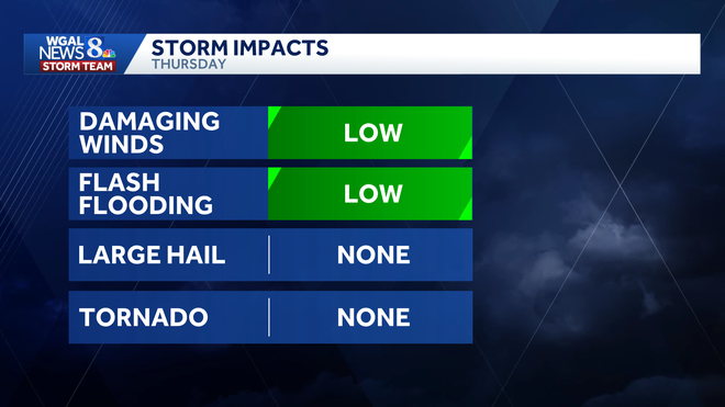
While Thursday’s storms are not expected to be as intense as the severe weather seen over the holiday weekend, a few isolated storms could produce:
Isolated damaging wind gusts Brief heavy rain
The risk for flash flooding is low, and large hail and tornadoes are not expected at this time.
Marginal risk
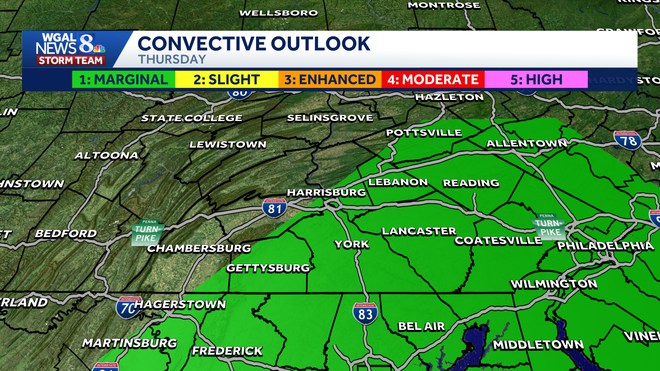
The following counties are in a marginal risk (level 1/5) for severe weather:
Lebanon Lancaster York Adams Southern Dauphin Southeastern Franklin
Looking ahead
Friday will be humid with highs in the mid-80s and a few afternoon showers and thunderstorms as a cold front passes. Severe weather and excessive rainfall are not expected at this time.
Next week starts in the mid-80s Monday before heat builds Tuesday through Thursday, with highs reaching the low 90s. Rain chances stay low overall, with only a slight chance for a few thunderstorms Wednesday.
Did you capture a moment that you would like to share with News 8? Send us your photos or videos at https://www.wgal.com/upload.