
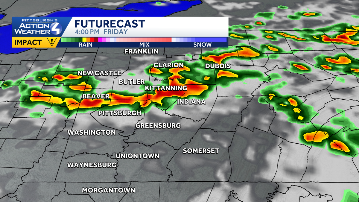
Western PA: Impact Day Friday for rain, flooding potential
Friday is an Impact Day for widespread rain and heavy downpours.
WEATHER WE’VE BEEN HAVING HERE. BRIAN HAS FELT LIKE FLORIDA HERE, THAT’S FOR SURE. AND WE ARE STICKING WITH THE HUMIDITY AND THE RAIN CHANCES AS WE HEAD TOWARDS THE END OF THE WEEK, THE WETTEST DAY IS GOING TO BE FRIDAY. THAT’S OUR IMPACT DAY. IT’S GOING TO STAY WARM AS WELL AS WE’RE STAYING IN THE 80S. AND AGAIN, THE HUMIDITY STAYS UP, WHICH MEANS YOU’LL LIKELY SEE ANOTHER ROUND OF FOG TOMORROW MORNING. AND AGAIN, ESPECIALLY IN THE MORNING, YOU’LL REALLY FEEL THE AIR AS YOU STEP OUTSIDE. AS WE LOOK FORWARD TO FRIDAY, BY THE TIME WE’RE DONE WITH OUR WIDESPREAD RAIN, WE COULD SEE ISOLATED SPOTS OF OVER AN INCH OF RAIN ACROSS THE AREA. THAT COULD OBVIOUSLY CAUSE FLOODING CONCERNS FROM ALL THE RAIN WE’VE RECEIVED OVER THE WEEKEND AND TO START THIS WEEK. SO BECAUSE OF THAT, FLOODING IS THE PRIMARY CONCERN THAT PROMPTS OUR IMPACT DAY. AS WE HEAD INTO YOUR FRIDAY. TOMORROW IS AN ISOLATED STORM. CHANCES 87 A LITTLE BETTER COVERAGE THAN TODAY, BUT THEY’LL STILL BE PRETTY HIT OR MISS THROUGH THE AFTERNOON. FRIDAY IS THE IMPACT DAY WITH RAIN AND STORMS AROUND THROUGH THE SECOND HALF OF THE DAY, ESPECIALLY WILL HOLD AT 82 ON SATURDAY, WITH A COUPLE OF SHOWERS STILL POTENTIALLY LEFT OVER. THEN WE DRY OUT. SUNDAY WE DROP THE HUMIDITY AS OUR LOWS HEAD BACK TO THE MIDDLE 60S, AND THEN THE HEAT IS ON AGAIN AS WE HEAD THROUGH NEXT WEEK. HIGHS WILL FLIRT WITH 90 BY TUESDAY. WE SHOULD GET THERE WEDNESDAY AND THURSDAY AS THE HUMIDITY RAMPS BACK UP. THIS DOES NOT LOOK AT THIS POINT NECESSARILY BE A STRONG HEAT WAVE, BUT WE ARE GOING TO BE WARM AS WE HEAD INTO THE MIDDLE AND BACK PART OF NEXT WEEK. STILL COULD SEE A STRAY SHOWER FOR ANOTHER COUPLE OF HOURS, BUT FOR THE MOST PART, WE’RE DONE WITH RAIN CHANCES TODAY. TOMORROW MORNING WE’LL SEE FOG AND WE’LL WATCH RAIN LIFTING NORTH OUT OF CENTRAL WEST VIRGINIA. THAT WILL LIKELY FIZZLE OUT AS IT CROSSES WESTERN PENNSYLVANIA BEFORE MORE SHOWERS AND STORMS ROLL THROUGH IN THE EARLY TO MID AFTERNOON HOURS TOMORROW. AGAIN, NOTICE VERY HIT OR MISS WITH SOME SHOWERS AND STORMS WILL BE AROUND THEN AS WE HEAD INTO YOUR. FRIDAY WILL LIKELY BE DRY OUT THE DOOR AND THEN WE’LL SEE SHOWERS AND STORMS BUBBLING UP INTO THE AFTERNOON AND EARLY EVENING HOURS AND AGAIN WHERE THE HEAVIEST RAIN FALLS. THAT’S WHERE WE’LL BE WATCHING FOR FLOODING CONCERNS AS RAIN TAPERS OFF. AS WE GET TO AND PAST SUNSET ON YOUR FRIDAY. AND THEN THAT SHOWER CHANCE LINGERS ON YOUR SATURDAY. SUNSHINE, THOUGH, POKING OUT FOR US ON ACTION CAM. AFTER WE HAD A MOSTLY CLOUDY START TO THE DAY, 86 IS THE CURRENT TEMPERATURE AT THE AIRPORT. IT FEELS LIKE IT’S 87 DEGREES OUTSIDE. IT’S GOING TO BE WARM AS WE HEAD THROUGH THE REST OF THE EVENING. WE’RE STARTING MILD. TOMORROW WILL WARM BACK TO THE UPPER 80S THROUGH THE DAY
Western PA: Impact Day Friday for rain, flooding potential
Friday is an Impact Day for widespread rain and heavy downpours.

Updated: 4:25 PM EDT Jul 8, 2026
Humidity levels remain elevated and continues to plague us. Humidity will gradually drop over the weekend, after we see a few days of rain chances. The wettest day this week will be Friday.Impact Day FridayWe will see some showers south of Pittsburgh to start our Thursday and isolated showers and storms in the afternoon. The best coverage of rain is here Friday.Friday will see rain showers and thunderstorms developing into the afternoon and early evening. Even though some storms are possible, severe weather looks unlikely as we move through the day. Storms though will produce heavy rainfall and some gusty winds. Rain should come to an end as we get to sunset. By the time rain is done late on Friday, some locations could pick up over an inch of rain, leading to localized flooding concerns late Friday. Quieter Weekend and Start to Next WeekShower chances may be possible this weekend, but any rain will be battling a ridge of high pressure setting up again across the area. Saturday is the best chance to see some rain, and that may be confined to mainly south of Interstate 70. Highs will warm into the start of next week with increasing sunshine. We will see 90° again by midweek. TONIGHT: A few clouds, patchy fog late. Low 69°.THURSDAY: Morning showers south then mostly cloudy with afternoon showers and storms. High: 87°, low: 69°.FRIDAY – Impact Day: Mostly cloudy with showers and storms. High: 82°, low: 68°.SATURDAY: Mostly cloudy with showers possible. High: 82°, low: 64°.
PITTSBURGH —
Humidity levels remain elevated and continues to plague us. Humidity will gradually drop over the weekend, after we see a few days of rain chances. The wettest day this week will be Friday.
Impact Day Friday
We will see some showers south of Pittsburgh to start our Thursday and isolated showers and storms in the afternoon. The best coverage of rain is here Friday.
Hearst Owned
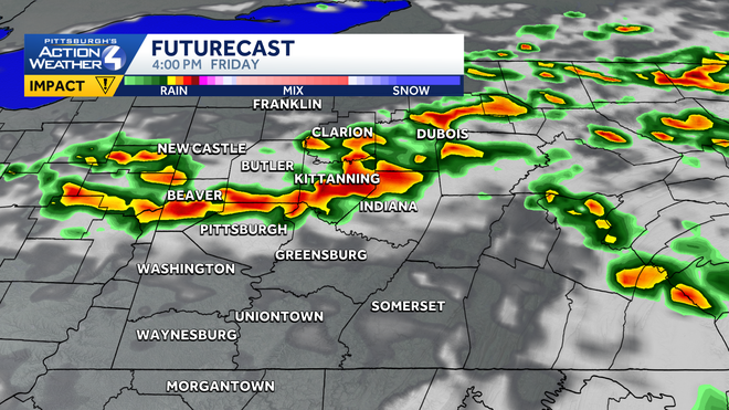
Heavy rain and a few storms are possible Friday afternoon. Friday is an Impact Day.
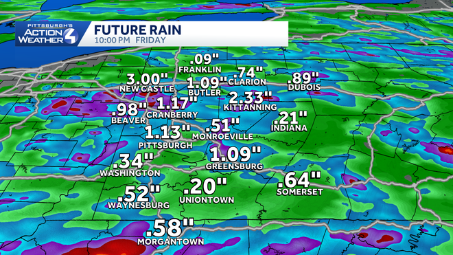
Friday will see rain showers and thunderstorms developing into the afternoon and early evening. Even though some storms are possible, severe weather looks unlikely as we move through the day. Storms though will produce heavy rainfall and some gusty winds. Rain should come to an end as we get to sunset. By the time rain is done late on Friday, some locations could pick up over an inch of rain, leading to localized flooding concerns late Friday.
Hearst Owned
Some spots could pick up over an inch of rain through late Friday, leading to localized flooding concerns.
Quieter Weekend and Start to Next Week
Shower chances may be possible this weekend, but any rain will be battling a ridge of high pressure setting up again across the area. Saturday is the best chance to see some rain, and that may be confined to mainly south of Interstate 70. Highs will warm into the start of next week with increasing sunshine. We will see 90° again by midweek.
Hearst Owned
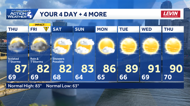
Daily rain chances end Saturday with the heat returning next week.
TONIGHT: A few clouds, patchy fog late. Low 69°.
THURSDAY: Morning showers south then mostly cloudy with afternoon showers and storms. High: 87°, low: 69°.
FRIDAY – Impact Day: Mostly cloudy with showers and storms. High: 82°, low: 68°.
SATURDAY: Mostly cloudy with showers possible. High: 82°, low: 64°.