
Humidity levels remain elevated and continues to plague us. Humidity will gradually drop over the weekend, after we see a few days of rain and storm chances. The wettest day this week will be Friday.Isolated Storms TodayWe can’t rule out isolated showers and storms today, especially through the early afternoon. Showers start to wrap up during the evening commute with a stray shower or two into the overnight.Impact Day – FridayWe will see some showers south of Pittsburgh to start our Thursday and isolated showers and storms in the afternoon. The best coverage of rain is here Friday.Friday will see rain showers and thunderstorms developing into the afternoon and early evening. Even though some storms are possible, severe weather looks unlikely as we move through the day. Storms though will produce heavy rainfall and some gusty winds. Rain should come to an end as we get to sunset. By the time rain is done late on Friday, some locations could pick up over an inch of rain, leading to localized flooding concerns late Friday.Weekend Dries Out… Warm Temps Next WeekShower chances may be possible this weekend, but any rain will be battling a ridge of high pressure setting up again across the area. Saturday is the best chance to see some rain, and that may be confined to mainly south of Interstate 70. Highs will warm into the start of next week with increasing sunshine. We will see 90° again by midweek.TODAY: AM showers south, sun/clouds with afternoon showers and storms. High: 87°TONIGHT: Isolated showers, mostly cloudy. Low 69°.FRIDAY – Impact Day: Mostly cloudy with showers and storms. High: 82°, low: 68°.SATURDAY: Mostly cloudy with a few PM showers. High: 82°, low: 64°.
Humidity levels remain elevated and continues to plague us. Humidity will gradually drop over the weekend, after we see a few days of rain and storm chances. The wettest day this week will be Friday.
Isolated Storms Today
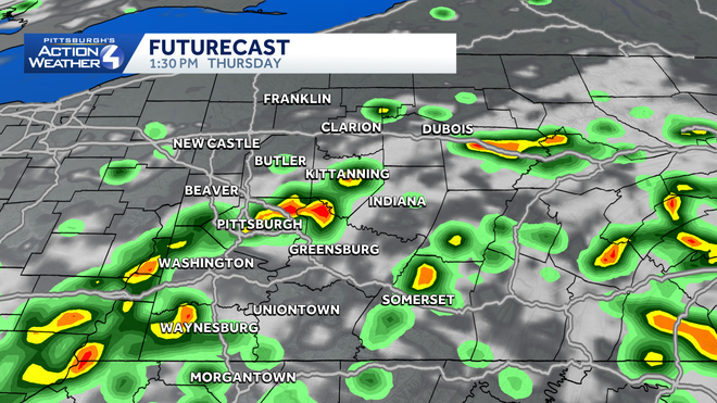
We can’t rule out isolated showers and storms today, especially through the early afternoon. Showers start to wrap up during the evening commute with a stray shower or two into the overnight.
Impact Day – Friday
We will see some showers south of Pittsburgh to start our Thursday and isolated showers and storms in the afternoon. The best coverage of rain is here Friday.
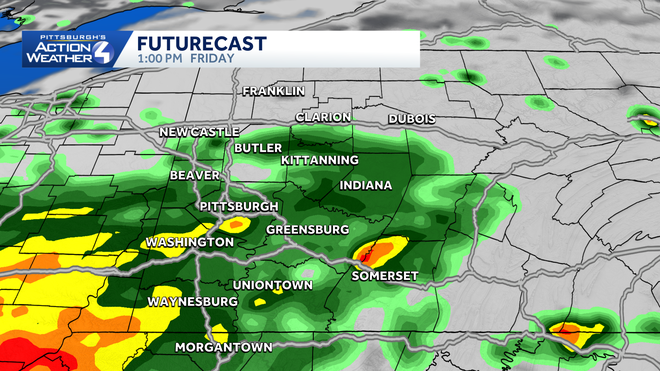
Friday will see rain showers and thunderstorms developing into the afternoon and early evening. Even though some storms are possible, severe weather looks unlikely as we move through the day. Storms though will produce heavy rainfall and some gusty winds. Rain should come to an end as we get to sunset. By the time rain is done late on Friday, some locations could pick up over an inch of rain, leading to localized flooding concerns late Friday.
Weekend Dries Out… Warm Temps Next Week
Shower chances may be possible this weekend, but any rain will be battling a ridge of high pressure setting up again across the area. Saturday is the best chance to see some rain, and that may be confined to mainly south of Interstate 70. Highs will warm into the start of next week with increasing sunshine. We will see 90° again by midweek.
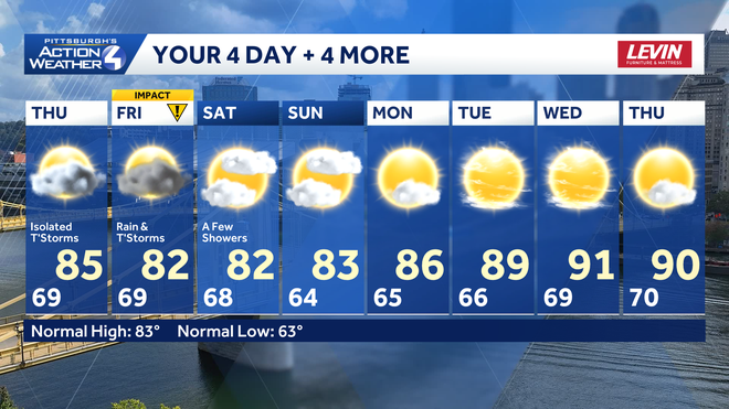
TODAY: AM showers south, sun/clouds with afternoon showers and storms. High: 87°
TONIGHT: Isolated showers, mostly cloudy. Low 69°.
FRIDAY – Impact Day: Mostly cloudy with showers and storms. High: 82°, low: 68°.
SATURDAY: Mostly cloudy with a few PM showers. High: 82°, low: 64°.