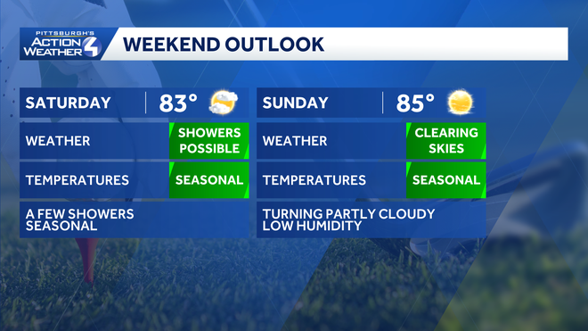
SOGGY THIS WEEK STILL? YEAH, WE ARE STILL SOGGY. AND IT’S REALLY THE HEAVY RAIN THAT’S FALLING THAT’S CAUSING THE PROBLEMS. A NEW REPORT OUT JUST IN ARMSTRONG COUNTY NEAR KITTANNING. TWO INCHES OF RAIN IN ABOUT 40 MINUTES. A LOT OF RAIN IS FALLING QUICKLY. AND THAT’S WHY OUR FLOOD WATCH IS IN EFFECT UNTIL 10:00 THIS EVENING. AND THIS IS FOR ALL OF WESTERN PENNSYLVANIA. WE’VE SEEN RAIN ACROSS THE AREA FOR MOST OF THE DAY TODAY, AND WE HAVE NUMEROUS FLASH FLOOD WARNINGS THAT ARE CURRENTLY IN EFFECT. ONE THOUGH, THAT WAS SOUTH OF THE CITY, THAT ONE WAS ALLOWED TO EXPIRE HERE. THEY CANCELED THAT ONE EARLY. WE DO HAVE TWO FLASH FLOOD WARNINGS INCLUDE ALLEGHENY COUNTY, INCLUDING THE CITY OF PITTSBURGH. THERE’S REPORTS OF FLOODING IN THE PORTION AS YOU HEAD DOWN TOWARDS MILLVILLE AND DOWN TOWARDS SHARPSBURG, WHERE FLOODING IS REPORTING ROSS TOWNSHIP OVER TO HAMPTON TOWNSHIP, OVER TOWARDS TARENTUM, SEEING POCKETS OF HEAVY RAIN THAT EXTENDS OFF TO THE NORTH AND WEST AND THE PORTIONS OF BEAVER COUNTY AS WELL, ESPECIALLY WEST OF THE BEAVER VALLEY EXPRESSWAY. SEEING A LOT OF HEAVY RAIN ALONG ROUTE 18. SO AGAIN, VERY WET HERE IN BEAVER COUNTY. AND AGAIN, THAT CONTINUES THROUGH PORTIONS OF ARMSTRONG AND INDIANA COUNTIES. AGAIN, THERE’S REPORTS TWO INCHES OF RAIN JUST OUTSIDE OF HERE IN ABOUT 40 MINUTES. SO THIS IS A LOT OF RAIN THAT’S FALLING. AND IT’S REALLY IF YOU GET THAT MUCH RAIN THAT QUICKLY, THAT’S GOING TO CAUSE FLOODING PROBLEMS AS WE ARE TOO SATURATED TO ABSORB ALL OF THAT QUICKLY. AND SO THAT’S WHY OUR FLASH FLOOD WARNINGS ARE NOW IN EFFECT. SO AGAIN, IF YOU SEE RAIN THE REST OF THE DAY, IF IT COMES DOWN HEAVILY, THAT COULD LEAD TO FLOODING PROBLEMS. WE WILL DRY OUT MORE TOMORROW. BUT WE ARE WATCHING FOR A SHOWER CHANCE. I’LL TIME THAT OUT HERE IN A SECOND. 83 TOMORROW, 85 ON SUNDAY. THEN TEMPERATURES BEGIN SKYROCKETING. WE CLIMB TO 90 BY TUESDAY. WE HOLD IN 90S THROUGH FRIDAY BEFORE TEMPERATURES START DROPPING NEXT SATURDAY. HUMIDITY WILL INCREASE, BUT IT WON’T BE AS BAD AS IT WAS JUST A WEEK AGO. BUT THE HEAT AND HUMIDITY ARE COMING BACK. SO AGAIN, THOSE SHOWERS AND STORMS ARE OUT THERE NOW. THEY WILL CONTINUE FOR ANOTHER FEW HOURS AFTER ABOUT 8:00. WE SHOULD SEE A GENERAL DOWNWARD TREND AS FAR AS THE SHOWERS AND STORMS GO. THAT LEADS TO A GENERALLY DRY NIGHT TONIGHT AS WINDS SHIFT AROUND FROM THE NORTH, THAT STARTS BRINGING IN DRIER AIR. AND AS WE HEAD THROUGH THE DAY ON SATURDAY, A COUPLE OF SHOWERS MAY FIRE, BUT IT LOOKS LIKE THE BEST COVERAGE WILL GENERALLY BE SOUTH OF THE CITY OF PITTSBURGH. AS WE HEAD THROUGH SATURDAY AFTERNOON AND EARLY EVENING. IF YOU’RE MAKING PLANS TO HEAD DOWN TO THE PIRATES GAME, BE AWARE WE MAY SEE A DELAY AS THE GAME STARTS WITH SHOWERS AND STORMS NEARBY. IF THE GAME CAN GET UNDERWA
Heavy rain, gusty winds and flood warnings in Western Pennsylvania

Updated: 5:43 PM EDT Jul 10, 2026
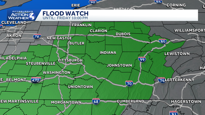
All of Western Pennsylvania is under a Flood Watch until 10 p.m. Friday with heavy rain expected through the area. Multiple counties are currently in a Flash Flood Warning through evening. Severe weather alerts: Read the current weather alert for your countyInteractive radar: Track storms moving through the areaWhere are the flash flood warnings?Flash Flood Warning until 8:30 p.m. for:West Central Allegheny CountyNorthwestern Washington County Southwestern Beaver CountySome locations that will experience flash flooding include… Moon Township, Weirton, Steubenville, Canonsburg, Wellsburg, Avella, Robinson Township, Cecil-Bishop, Coraopolis, Bridgeville, Toronto, Wintersville, Mingo Junction, Follansbee, McGovern and Hooverson Heights.Flash Flood Warning until 6:15 p.m. for:Southern Armstrong CountySouthwestern Indiana CountySome locations that will experience flash flooding include… Homer City, Ford City, Freeport, Black Lick, West Lebanon, Manorville, Ford Cliff, Elderton, Lenape Heights, Shelocta, Jacksonville, Lucerne Mines, Brush Valley and Crooked Creek Lake Park. Flash Flood Warning until 7 p.m. for:Northern Allegheny CountySouthern Butler CountyBeaver CountySouthwestern Lawrence CountySome locations that will experience flash flooding include… Ross Township, McCandless, Cranberry, Moon Township, Franklin Park, East Liverpool, Aliquippa, Beaver Falls, Monaca, East Palestine, Wellsville, Shaler Township, Hampton Township, Harrison Township, Economy and Ellwood City.Flash Flood Warning until 6:15 p.m. for:Central Allegheny CountySome locations that will experience flash flooding include… Pittsburgh, Penn Hills, Ross Township, McCandless, Monroeville, Shaler Township, Plum, North Side, Baldwin, Hampton Township, Scott Township, Wilkinsburg, Robinson Township and Munhall.Impact Day – Scattered Storms, Flood WatchScattered rain and storms continue into the evening. Storms will produce heavy rainfall and some gusty winds. Rain should come to an end as we get close to sunset.By the time rain is done late on Friday, some localized locations could pick up over an inch of rain, leading to localized flooding concerns. The night will dry out. WTAE app: Download it now to stay connected with breaking news & weatherSevere weather alerts: Sign up to receive free alerts to your phone or email
PITTSBURGH —
All of Western Pennsylvania is under a Flood Watch until 10 p.m. Friday with heavy rain expected through the area.
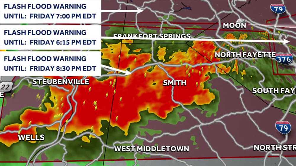
Multiple counties are currently in a Flash Flood Warning through evening.
Where are the flash flood warnings?
Flash Flood Warning until 8:30 p.m. for:
West Central Allegheny CountyNorthwestern Washington County Southwestern Beaver County
Some locations that will experience flash flooding include… Moon Township, Weirton, Steubenville, Canonsburg, Wellsburg, Avella, Robinson Township, Cecil-Bishop, Coraopolis, Bridgeville, Toronto, Wintersville, Mingo Junction, Follansbee, McGovern and Hooverson Heights.
Flash Flood Warning until 6:15 p.m. for:
Southern Armstrong CountySouthwestern Indiana County
Some locations that will experience flash flooding include… Homer City, Ford City, Freeport, Black Lick, West Lebanon, Manorville, Ford Cliff, Elderton, Lenape Heights, Shelocta, Jacksonville, Lucerne Mines, Brush Valley and Crooked Creek Lake Park.
Flash Flood Warning until 7 p.m. for:
Northern Allegheny CountySouthern Butler CountyBeaver CountySouthwestern Lawrence County
Some locations that will experience flash flooding include… Ross Township, McCandless, Cranberry, Moon Township, Franklin Park, East Liverpool, Aliquippa, Beaver Falls, Monaca, East Palestine, Wellsville, Shaler Township, Hampton Township, Harrison Township, Economy and Ellwood City.
Flash Flood Warning until 6:15 p.m. for:
Some locations that will experience flash flooding include… Pittsburgh, Penn Hills, Ross Township, McCandless, Monroeville, Shaler Township, Plum, North Side, Baldwin, Hampton Township, Scott Township, Wilkinsburg, Robinson Township and Munhall.
Impact Day – Scattered Storms, Flood Watch
Scattered rain and storms continue into the evening. Storms will produce heavy rainfall and some gusty winds. Rain should come to an end as we get close to sunset.
By the time rain is done late on Friday, some localized locations could pick up over an inch of rain, leading to localized flooding concerns. The night will dry out.