
Areas of patchy fog, mainly south of I70 this morning While a stray shower can’t be ruled out, we should now enter a dry spell that will take us through most of the upcoming week.Increasing Heat and HumidityOur dry stretch with sunshine will continue through next week, but the heat cranks up! Highs will warm back to 90 by Tuesday with us staying there on Wednesday. Wednesday should be the hottest and most humid day where it will feel like we are close to 100 degrees.The good news is the heat, and humidity will be short lived as highs start dropping as we approach the weekend. We will have to watch for a rain chance at some point late week, but as of now, no one day stands out. Highs return to normal for this time of year by next Sunday.TODAY: Mostly sunny to partly cloudy, less humid. High: 85°TONIGHT: Mostly clear and warm. Low 65°.MONDAY: Mostly sunny and warmer. High: 87°, low: 67°.TUESDAY: Mostly sunny and more humid. High: 90°, low: 70°. Feels like the mid 90s.
Areas of patchy fog, mainly south of I70 this morning While a stray shower can’t be ruled out, we should now enter a dry spell that will take us through most of the upcoming week.
Increasing Heat and Humidity
Our dry stretch with sunshine will continue through next week, but the heat cranks up! Highs will warm back to 90 by Tuesday with us staying there on Wednesday. Wednesday should be the hottest and most humid day where it will feel like we are close to 100 degrees.
The good news is the heat, and humidity will be short lived as highs start dropping as we approach the weekend. We will have to watch for a rain chance at some point late week, but as of now, no one day stands out. Highs return to normal for this time of year by next Sunday.
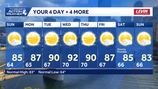
TODAY: Mostly sunny to partly cloudy, less humid. High: 85°
TONIGHT: Mostly clear and warm. Low 65°.
MONDAY: Mostly sunny and warmer. High: 87°, low: 67°.
TUESDAY: Mostly sunny and more humid. High: 90°, low: 70°. Feels like the mid 90s.