
90s Return to Pittsburgh this Week
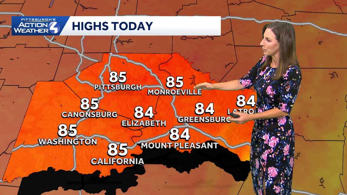
IN. NOT AS BAD AS THAT FIRST HEAT WAVE, AND WE HAVE THE POTENTIAL TO HIT A HEAT WAVE. YOU HAVE TO HAVE OFFICIALLY THREE CONSECUTIVE DAYS OR MORE OF 90 DEGREES OR HIGHER. EITHER WAY, IT’S GOING TO BE HOT. IT’S GOING TO BE MUGGY. RAIN CHANCES WILL BE SLIM TODAY, BUT AS THAT HIGH PRESSURE BUILDS IN, IT COULD FIRE OFF A POP UP SHOWER. RIGHT NOW THOUGH, WE DO HAVE SOME HIGH CLOUDS AND THAT SUNRISE IS JUST ABSOLUTELY STUNNING THIS MORNING. NOT JUST DOWNTOWN PITTSBURGH, BUT ALL AROUND WESTERN PENNSYLVANIA. SO IF YOU’RE GETTING READY TO HEAD OUT, MAYBE SOME EARLY CHURCH SERVICES, MAYBE A LITTLE BIT OF AN ISSUE, 69 DEGREES RIGHT NOW IN PITTSBURGH, WINDS ARE OUT OF THE NORTHEAST ABOUT THREE MILES PER HOUR, 66 IN KITTANNING AND CRANBERRY UNIONTOWN, SITTING AT 67, BEAVER AT 64. 64 ALSO IN FRANKLIN. WE’RE GOING TO JUMP UP NEAR 85 TODAY IN CRANBERRY AND BUTLER 84 INTO INDIANA. OIL CITY WILL HIT NEAR 86 IN NEW CASTLE. OUR WARMEST SPOT AT 8777, THOUGH IN SEVEN SPRINGS AND SOMERSET, 84 IN UNIONTOWN AND MORGANTOWN WILL BE INTO THE MID 80S. MID TO UPPER 80S IN AND AROUND THE CITY OF PITTSBURGH. WASHINGTON UP NEAR 8584. IN LATROBE THIS AFTERNOON. SO LOOKING AT YOUR 4-DAY PLUS 4 MORE FORECAST, THOSE TEMPERATURES WILL GRADUALLY CLIMB INTO THE LOW 90S FOR THE MIDDLE OF THE WEEK. WE’LL BE WATCHING FOR STORM CHANCES COMING FRIDAY, SATURDAY, POTENTIALLY LEADING INTO NEXT SUNDAY. BUT THROUGH THE DAY TODAY. OVERALL, NOT BAD AS THIS HIGH STARTS TO BUILD IN. IT COULD PICK UP SOME OF THIS MOISTURE FROM THE SOUTH, WHICH COULD FIRE OFF ALONG INTERSTATE 70 ON SOUTH AS EARLY AS SIX 7:00 THIS EVENING. COULD EVEN HIT PARTS OF WASHINGTON AND SOUTHERN ALLEGHENY COUNTY. SO THERE’S YOUR FOUR DAY PLUS FOUR MORE FORECAST. IF YOU’RE HEADING TO THE PIRATES GAME TODAY, SHOULDN’T BE TOO BAD FOR YOU. JUST MAKE SURE YOU HAVE THAT SUNBLOCK ON. TEMPERATURES WILL BE INTO THE LOW 80S DURING GAME TIME. SEVENTH INNING STRETCH WILL BE NEAR 2 TO 30, BUT SEASONAL FOR US, WE REALLY START TO HEAT UP THOUGH FOR THE MIDDLE OF NEXT WEEK. AND IT’S NOT JUST THE DAYTIME HIGHS, IT’S ALSO THE MORNING TEMPERATURES AS WE CLIMB INTO THE UPPER 60S AND LOW 70S. SO NEEDLESS TO SAY, IT’S GOING TO BE HOT. IT’S GOING TO BE MUGGY IF YOU’RE SENSITIVE T
Areas of patchy fog, mainly south of I70 this morning While a stray shower can’t be ruled out, we should now enter a dry spell that will take us through most of the upcoming week.Increasing Heat and HumidityOur dry stretch with sunshine will continue through next week, but the heat cranks up! Highs will warm back to 90 by Tuesday with us staying there on Wednesday. Wednesday should be the hottest and most humid day where it will feel like we are close to 100 degrees.The good news is the heat, and humidity will be short lived as highs start dropping as we approach the weekend. We will have to watch for a rain chance at some point late week, but as of now, no one day stands out. Highs return to normal for this time of year by next Sunday.TODAY: Mostly sunny to partly cloudy, less humid. High: 85°TONIGHT: Mostly clear and warm. Low 65°.MONDAY: Mostly sunny and warmer. High: 87°, low: 67°.TUESDAY: Mostly sunny and more humid. High: 90°, low: 70°. Feels like the mid 90s.
Areas of patchy fog, mainly south of I70 this morning While a stray shower can’t be ruled out, we should now enter a dry spell that will take us through most of the upcoming week.
Increasing Heat and Humidity
Our dry stretch with sunshine will continue through next week, but the heat cranks up! Highs will warm back to 90 by Tuesday with us staying there on Wednesday. Wednesday should be the hottest and most humid day where it will feel like we are close to 100 degrees.
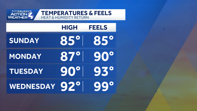
The good news is the heat, and humidity will be short lived as highs start dropping as we approach the weekend. We will have to watch for a rain chance at some point late week, but as of now, no one day stands out. Highs return to normal for this time of year by next Sunday.
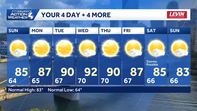
TODAY: Mostly sunny to partly cloudy, less humid. High: 85°
TONIGHT: Mostly clear and warm. Low 65°.
MONDAY: Mostly sunny and warmer. High: 87°, low: 67°.
TUESDAY: Mostly sunny and more humid. High: 90°, low: 70°. Feels like the mid 90s.