IMPACT DAY: Heat wave begins as 100-degree feels grip south-central Pennsylvania
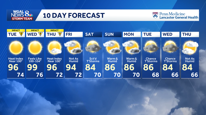
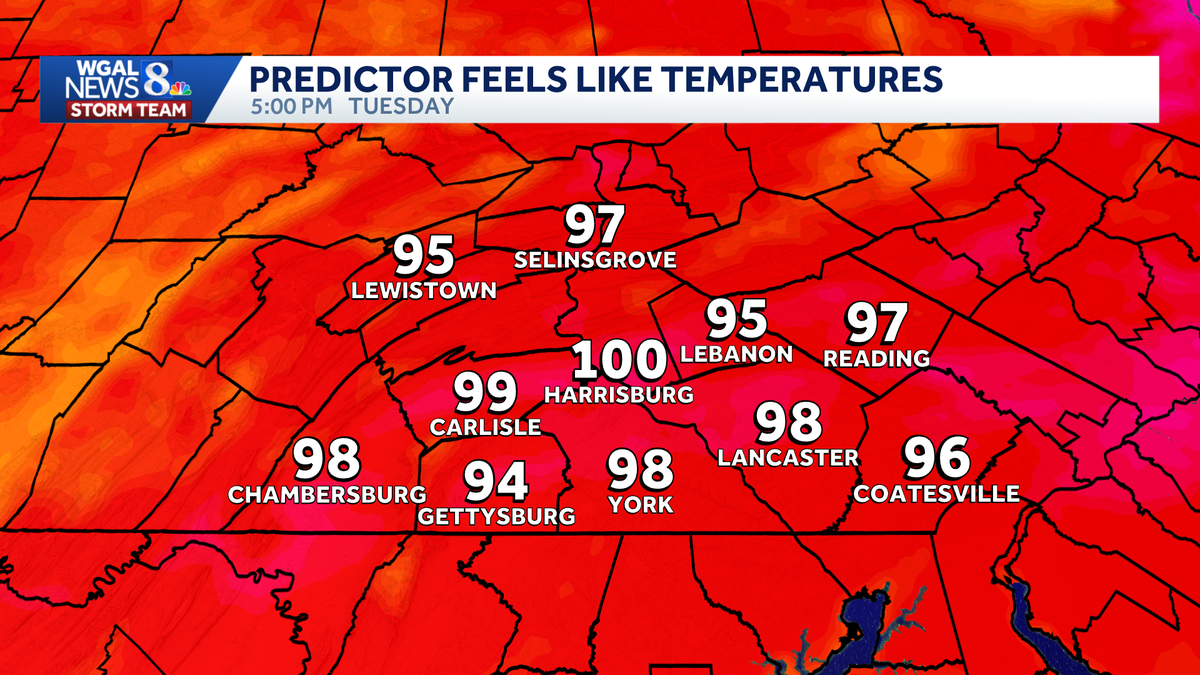
Now the WGAL News 8 storm team forecast with Chief meteorologist Christine Ferreira. Good morning. Let’s go over the heat alerts today. We have *** heat advisory for the counties in Orange from 11:00 a.m. until 8:00 p.m. That means the heat index that feels like temperature is going to be near 100 or exceeding 100 in these spots. Southern counties, it’ll be close, feeling like the upper 90s maybe briefly touching 100. Now tomorrow, everybody’s under *** heat advisory, same time period, 11 to 8. We are looking for heat index values in the low 100s tomorrow. We could very well hit the upper 90s for our high and That is the record. The record stands at 99 on Wednesday. 96 is our forecast high on Thursday, 90 for Friday. So this is *** 4 day heat wave this time around, but still pretty intense. The humidity does drop *** bit by Friday, so that’ll be some relief. Then we get more relief with temperatures in the 80s this weekend and increased rain chances. Today our News 8 storm team forecast says sunny skies, more humid, *** heat index near 100 in many spots. Highs about 10 degrees warmer than yesterday. Tonight, clear, muggy. Overnight lows are going to drop down into the 70s, and tomorrow we have blazing sunshine impacts or feels like temperatures 100 to 1004 heat advisory in effect for us tomorrow. Looking back at yesterday, our high was 86. Average is 87, and we are going to see temperatures about 10 degrees warmer today. So be prepared for that change. It’s *** big jump from where we were yesterday. Temperatures right now 64 in Lebanon 65 in York, 68 degrees in Chambersburg, and look at those dew points, low 60s, so feeling *** little sticky now but OK. Dew points will be in the mid-60s later and then we go for dew points near 70 tomorrow, really turning up that sultry heat. Weather and health, some changes today. Direct your attention to the UV index, which is very high, *** burn time of just 15 minutes. Air quality is moderate, and our mold spores are moderate. Here’s the storm team live radar network. All is quiet and dry. We have *** big area of high pressure right overhead, and that extends all the way back into the Midwestern Plains. So we’re not the only ones dealing with this heat or this heat wave this week. Here’s what the predictor says. Hardly *** cloud in the sky for us today. We have wall to wall sunshine and blazing hot sunshine come tomorrow. So tomorrow. Highs could touch 100 in some spots. Wouldn’t be shocked to see that for the actual air temperature and feels like low 100s for Thursday. Notice we get *** boundary that drops in from the north. Predictor says, uh, there might be *** stray shower with that in the morning, but I don’t see much in the afternoon. We should see clearing skies and then lower humidity, which will help out *** little bit. It won’t make it feel quite as intense at the end of the week. So here’s your feels like temperatures today. Some spots touching that 100 mark. Other spots will be close. Tomorrow, everybody feels like 100, low 100s definitely out there. And then finally on Thursday as the humidity drops *** little bit, still hot, still humid, but just not as intense as Wednesday. Here’s the 10 day forecast. Temperature wise we’re going to be looking at 90s all the way through Friday, then *** long stretch of 80s, *** little more typical for this time of the year. In fact, some days may even be slightly below average starting on Saturday. Best rain chances look to be Saturday and again next Tuesday into Wednesday.
IMPACT DAY: Heat wave begins as 100-degree feels grip south-central Pennsylvania

Updated: 6:43 AM EDT Jul 14, 2026
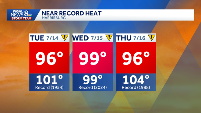
An intense stretch of summer heat has arrived in south-central Pennsylvania, with rising humidity and heat index values above 100 degrees. The WGAL News 8 Storm Team has declared Tuesday through Thursday as Impact Days, meaning the weather will likely disrupt your normal daily schedule or routine. Heat wave begins TuesdayHigh pressure will bring full sunshine and hotter temperatures Tuesday, with afternoon highs around 96 degrees and a burn time of about 15 minutes. Humidity will be higher than Monday, though not yet oppressive. A heat advisory was issued for the following counties from 11 a.m. to 8 p.m. on Tuesday: DauphinJuniataLebanonMifflinPerryHighs in the mid-90s, combined with dew points in the upper 60s, will make it feel like 100 degrees in those areas. Elsewhere, the heat index is expected to come close to 100. Wednesday will be even hotterWednesday will likely be the hottest day of the stretch, with highs soaring to 99 degrees and tropical humidity pushing heat index values to 100 to 104 degrees. A heat advisory was also issued for Wednesday from 11 a.m. to 8 p.m. for the entire Susquehanna Valley. NEAR-RECORD HEAT: Harrisburg’s record high for Wednesday is 99 degrees, set in 2024, meaning the city could come close to tying that mark. Heat lingers Thursday before easingThe heat is expected to ease slightly later in the week, though conditions will remain hot. Forecast highs: Tuesday: 96Wednesday: 99Thursday: 96Friday: 94Saturday: 84Sunday: 86Humidity levels should begin to drop by the end of the week, making the heat less intense. Thursday is expected to remain humid, while Friday will feel somewhat less oppressive. A slight chance of thunderstorms is in the forecast for Friday. Safety precautionsResidents are urged to take precautions during the heat wave, including:Drink plenty of waterTake frequent breaks if working outdoorsWear light-colored, loose-fitting clothingLimit strenuous activity during the afternoonCheck on older adults, children and pets
An intense stretch of summer heat has arrived in south-central Pennsylvania, with rising humidity and heat index values above 100 degrees.
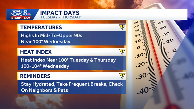
The WGAL News 8 Storm Team has declared Tuesday through Thursday as Impact Days, meaning the weather will likely disrupt your normal daily schedule or routine.
Heat wave begins Tuesday
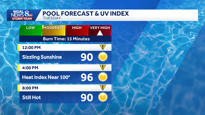
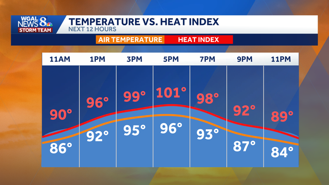
High pressure will bring full sunshine and hotter temperatures Tuesday, with afternoon highs around 96 degrees and a burn time of about 15 minutes. Humidity will be higher than Monday, though not yet oppressive.
A heat advisory was issued for the following counties from 11 a.m. to 8 p.m. on Tuesday:
DauphinJuniataLebanonMifflinPerry
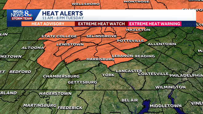
Highs in the mid-90s, combined with dew points in the upper 60s, will make it feel like 100 degrees in those areas. Elsewhere, the heat index is expected to come close to 100.
Wednesday will be even hotter
Wednesday will likely be the hottest day of the stretch, with highs soaring to 99 degrees and tropical humidity pushing heat index values to 100 to 104 degrees.
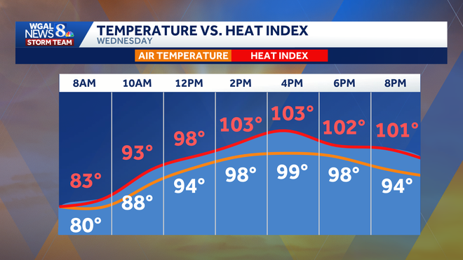
A heat advisory was also issued for Wednesday from 11 a.m. to 8 p.m. for the entire Susquehanna Valley.
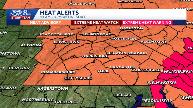
NEAR-RECORD HEAT: Harrisburg’s record high for Wednesday is 99 degrees, set in 2024, meaning the city could come close to tying that mark.
Heat lingers Thursday before easing
The heat is expected to ease slightly later in the week, though conditions will remain hot.
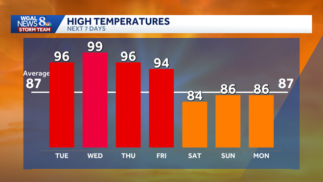
Forecast highs:
Tuesday: 96Wednesday: 99Thursday: 96Friday: 94Saturday: 84Sunday: 86
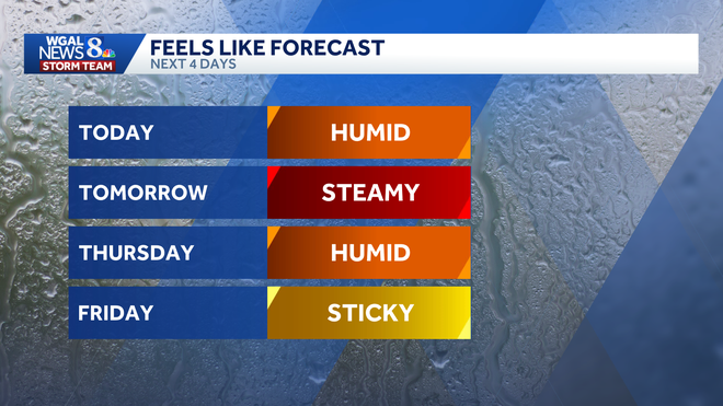
Humidity levels should begin to drop by the end of the week, making the heat less intense. Thursday is expected to remain humid, while Friday will feel somewhat less oppressive. A slight chance of thunderstorms is in the forecast for Friday.
Safety precautions
Residents are urged to take precautions during the heat wave, including:
Drink plenty of waterTake frequent breaks if working outdoorsWear light-colored, loose-fitting clothingLimit strenuous activity during the afternoonCheck on older adults, children and pets