
IMPACT: Heatwave Starts Today, Lasts Through Friday In South Central Pennsylvania
A Heat Advisory is in effect for northern counties today, and all counties on Wednesday.

Updated: 1:02 PM EDT Jul 14, 2026
Good afternoon,IMPACT: HEAT ADVISORY IN EFFECTHigh pressure will provide full sunshine and warmer temperatures today. Expect highs around 96°. Humidity will be higher than on Monday, but not oppressive.A Heat Advisory is in effect for Mifflin, Juniata, Perry, Dauphin, and Lebanon Counties until 8 p.m. today. In these areas, highs in the mid-90s, combined with dew points in the upper 60s will make it feel like 100 degrees. The rest of the area will have a heat index just shy of 100 degrees.Wednesday’s high will soar to 99°, with more tropical humidity levels. Wednesday’s record high in Harrisburg is 99°, set in 2024.A Heat Advisory is in effect for all counties in the Susquehanna Valley from 11 a.m. until 8 p.m. Wednesday. Highs in the upper 90s, combined with dew points near 70° will make it feel like 100-104 degrees.HOT END TO THE WEEKThe heat eases slightly on Thursday as a weak cold front drops south. Humidity levels will drop slightly, but the heat index could still be near 100, with a high of 96.By Friday, humidity levels will drop more, so the heat won’t be as intense. Highs will reach 94 degrees on Friday. A slight chance of thunderstorms is also in the forecast.WEEKEND RAIN CHANCESTemperatures will fall to the mid-80s on Saturday and Sunday. Scattered thunderstorms are in the forecast Saturday, and there’s a slight chance Sunday.Next week, temperatures will stay near seasonable averages, in the mid-80s. Dew points will hover in the 60s, which is typical for July. There’s a slim chance of thunderstorms on Monday, then a better chance on Tuesday and Wednesday.Have a great day!
Good afternoon,
IMPACT: HEAT ADVISORY IN EFFECT
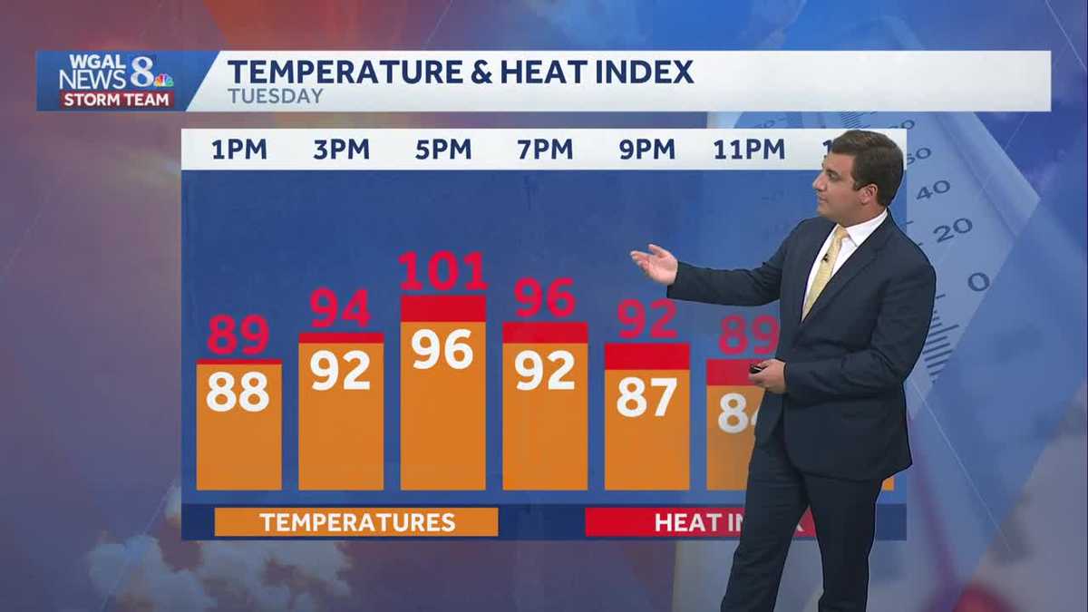
High pressure will provide full sunshine and warmer temperatures today. Expect highs around 96°. Humidity will be higher than on Monday, but not oppressive.
A Heat Advisory is in effect for Mifflin, Juniata, Perry, Dauphin, and Lebanon Counties until 8 p.m. today. In these areas, highs in the mid-90s, combined with dew points in the upper 60s will make it feel like 100 degrees. The rest of the area will have a heat index just shy of 100 degrees.
Wednesday’s high will soar to 99°, with more tropical humidity levels. Wednesday’s record high in Harrisburg is 99°, set in 2024.
A Heat Advisory is in effect for all counties in the Susquehanna Valley from 11 a.m. until 8 p.m. Wednesday. Highs in the upper 90s, combined with dew points near 70° will make it feel like 100-104 degrees.
HOT END TO THE WEEK
The heat eases slightly on Thursday as a weak cold front drops south. Humidity levels will drop slightly, but the heat index could still be near 100, with a high of 96.
By Friday, humidity levels will drop more, so the heat won’t be as intense. Highs will reach 94 degrees on Friday. A slight chance of thunderstorms is also in the forecast.
WEEKEND RAIN CHANCES
Temperatures will fall to the mid-80s on Saturday and Sunday. Scattered thunderstorms are in the forecast Saturday, and there’s a slight chance Sunday.
Next week, temperatures will stay near seasonable averages, in the mid-80s. Dew points will hover in the 60s, which is typical for July. There’s a slim chance of thunderstorms on Monday, then a better chance on Tuesday and Wednesday.
Have a great day!