
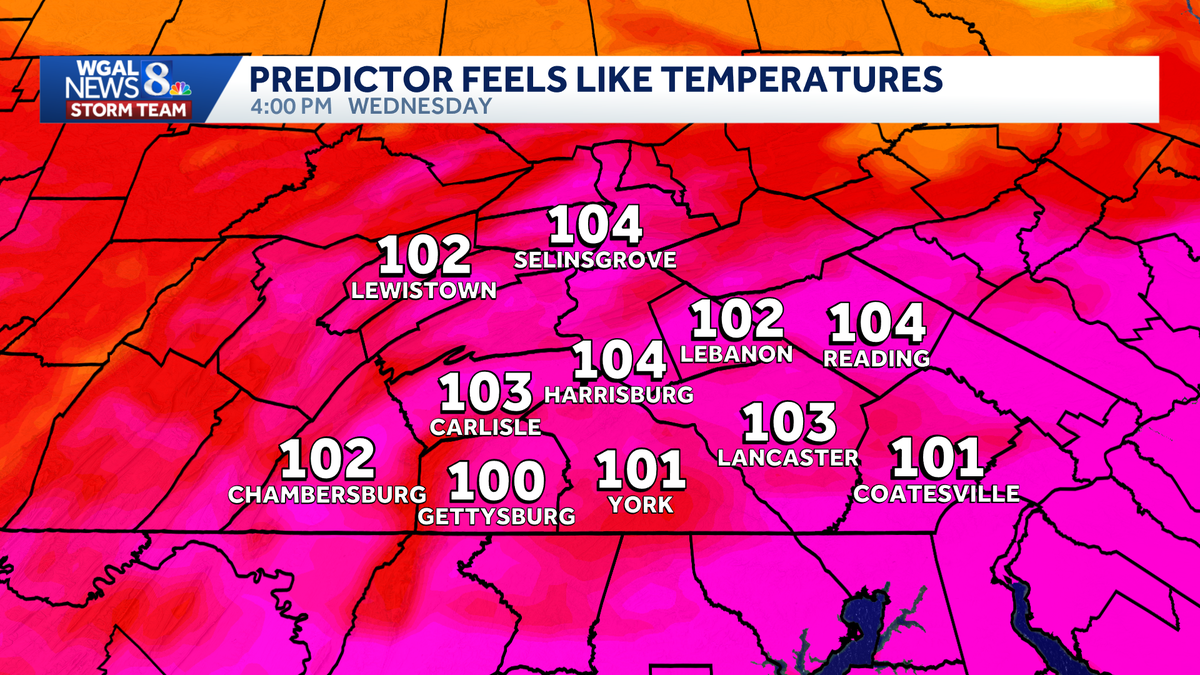
Hottest day of the week with heat advisory in effect, triple-digit feels in south-central Pennsylvania
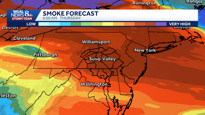
Now the impact *** forecast from the WGAL News 8 storm team. Good morning. It is 6:48. Did you notice the milky white appearance in the sky yesterday? That was Canadian wildfire smoke coming all the way here from Ontario. It was way high up in the sky, so no impact to surface air quality. But if we get *** thicker plume, we might see some minor impacts to surface air quality perhaps tonight and tomorrow. Let me show you. Here’s *** look at the smoke forecast for today. We are in. Clean plume, so you’ll notice brighter blue sky today. Still *** little haze out there, but not as much haze as yesterday. Watch this plume dropping south tonight. This is at 10:00 p.m. Real thick plume overnight tonight in the Susquehanna Valley, and it lingers throughout the day tomorrow. So we’ll have to watch the sky, see how low the smoke goes. If any of it gets mixed down close to the surface, that could impact our surface air quality, but it will look hazy, that’s for sure, tomorrow, and then. Haze also blocks the sun, which lowers our temperature, so the heat might not be as intense tomorrow thanks to the smoke. Today, News 8 storm team forecast says mostly sunny this morning. It’s muggy out there. It’s certainly warm at 9 o’clock. We’ll be around 84, which is close to our average high this afternoon. We could challenge records. The record stands at 99 degrees, forecasting upper 90s with feels like temperatures well into the 100s. And this evening, the haze thickens. It’ll be hot and humid. Even at 8 o’clock we are still in the 90s tonight. Not much relief from the temperatures, 74 to 78 degrees. Hazy skies overnight and that plume of haze lingers tomorrow, so the sky may look *** little bit like this dark and kind of dim. Not much sun getting through. I had to lower our highs for tomorrow. We should still make the 90s, but it won’t be as intense as what we were expecting earlier in the week due to the smoke. Feeling like the mid to upper 90s for you tomorrow. Here’s the temperatures right now. We have 75 in Harrisburg, 75 in Lebanon. Good morning, Lancaster, at 71. pair of 7s in Lewistown. Certainly *** warm start for you. 68 is the dew point in Lewistown. Upper 60s for dew points right now. It gives the air that warm and stuffy feeling. Weather and health update today. Check out our UV index. Very high with *** burn time of just 15 minutes. With more sun expected today, we should see that higher burn time verify. Here’s the storm team live radar network. High pressure, the big heat dome we’ve been talking about that this week. It is still smack dab on top of Pennsylvania. There is *** boundary, *** weak cold front up in the northeast, and eventually that drops south tomorrow, so you’ll notice some cooler temperatures, lower humidity values by the end of the week. Today it’s the hottest, most humid day of the week. High pressure right overhead. We have high temperatures in the upper 90s. It is going to be sultry outside tomorrow. We start the day with that smoke and haze, some clouds as well, and watch this front as it drops south. The predictor says, hey, there may be *** stray shower in our southern counties tomorrow. Afternoon tomorrow evening. I’ll keep an eye on that for you. The chance is pretty slim though. As we get into Friday, we could still be dealing with some smoke and haze from the wildfires. Otherwise temperatures in the lower 90s on Friday. Here’s how hot it’s going to feel today. It’s going to feel like the triple digits, the peak of the heat wave this week, and it’s *** 4 day heat wave this time around. Tomorrow not as intense. The temperatures won’t be as hot. The humidity won’t be as high, but it’ll still feel like the mid to upper 90s. By Friday, not as humid, 92. Saturday we drop to more seasonable temperatures, 86 with *** chance of showers and storms. And next week I’m watching *** cold front on Tuesday which will help to lower humidity Wednesday and Thursday.
Now the impact *** forecast from the WGAL News 8 storm team. Good morning. It is 6:48. Did you notice the milky white appearance in the sky yesterday? That was Canadian wildfire smoke coming all the way here from Ontario. It was way high up in the sky, so no impact to surface air quality. But if we get *** thicker plume, we might see some minor impacts to surface air quality perhaps tonight and tomorrow. Let me show you. Here’s *** look at the smoke forecast for today. We are in. Clean plume, so you’ll notice brighter blue sky today. Still *** little haze out there, but not as much haze as yesterday. Watch this plume dropping south tonight. This is at 10:00 p.m. Real thick plume overnight tonight in the Susquehanna Valley, and it lingers throughout the day tomorrow. So we’ll have to watch the sky, see how low the smoke goes. If any of it gets mixed down close to the surface, that could impact our surface air quality, but it will look hazy, that’s for sure, tomorrow, and then. Haze also blocks the sun, which lowers our temperature, so the heat might not be as intense tomorrow thanks to the smoke. Today, News 8 storm team forecast says mostly sunny this morning. It’s muggy out there. It’s certainly warm at 9 o’clock. We’ll be around 84, which is close to our average high this afternoon. We could challenge records. The record stands at 99 degrees, forecasting upper 90s with feels like temperatures well into the 100s. And this evening, the haze thickens. It’ll be hot and humid. Even at 8 o’clock we are still in the 90s tonight. Not much relief from the temperatures, 74 to 78 degrees. Hazy skies overnight and that plume of haze lingers tomorrow, so the sky may look *** little bit like this dark and kind of dim. Not much sun getting through. I had to lower our highs for tomorrow. We should still make the 90s, but it won’t be as intense as what we were expecting earlier in the week due to the smoke. Feeling like the mid to upper 90s for you tomorrow. Here’s the temperatures right now. We have 75 in Harrisburg, 75 in Lebanon. Good morning, Lancaster, at 71. pair of 7s in Lewistown. Certainly *** warm start for you. 68 is the dew point in Lewistown. Upper 60s for dew points right now. It gives the air that warm and stuffy feeling. Weather and health update today. Check out our UV index. Very high with *** burn time of just 15 minutes. With more sun expected today, we should see that higher burn time verify. Here’s the storm team live radar network. High pressure, the big heat dome we’ve been talking about that this week. It is still smack dab on top of Pennsylvania. There is *** boundary, *** weak cold front up in the northeast, and eventually that drops south tomorrow, so you’ll notice some cooler temperatures, lower humidity values by the end of the week. Today it’s the hottest, most humid day of the week. High pressure right overhead. We have high temperatures in the upper 90s. It is going to be sultry outside tomorrow. We start the day with that smoke and haze, some clouds as well, and watch this front as it drops south. The predictor says, hey, there may be *** stray shower in our southern counties tomorrow. Afternoon tomorrow evening. I’ll keep an eye on that for you. The chance is pretty slim though. As we get into Friday, we could still be dealing with some smoke and haze from the wildfires. Otherwise temperatures in the lower 90s on Friday. Here’s how hot it’s going to feel today. It’s going to feel like the triple digits, the peak of the heat wave this week, and it’s *** 4 day heat wave this time around. Tomorrow not as intense. The temperatures won’t be as hot. The humidity won’t be as high, but it’ll still feel like the mid to upper 90s. By Friday, not as humid, 92. Saturday we drop to more seasonable temperatures, 86 with *** chance of showers and storms. And next week I’m watching *** cold front on Tuesday which will help to lower humidity Wednesday and Thursday.
Hottest day of the week with heat advisory in effect, triple-digit feels in south-central Pennsylvania

Updated: 7:03 AM EDT Jul 15, 2026
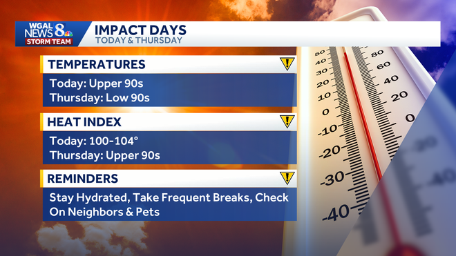
A heat wave is continuing across south-central Pennsylvania as oppressive heat and humidity push feels-like temperatures above 100 degrees. The WGAL News 8 Storm Team has declared Wednesday and Thursday as Impact Days, meaning the weather will likely disrupt your normal daily schedule or routine. Heat advisoryWednesday is expected to be the hottest day of the week. Afternoon temperatures in the upper 90s, combined with dew points near 70, will make it feel as hot as 100 to 104 degrees. A heat advisory is in effect for the entire Susquehanna Valley from 11 a.m. to 8 p.m. Near-record heatIn Harrisburg, the high is expected to reach 97 degrees Wednesday, just shy of the daily record of 99 set in 2024. Heat eases slightly, but stays uncomfortableThe heat is expected to ease somewhat on Thursday as a weak cold front drops south. Humidity should come down slightly, but it will still feel like the upper 90s, with a high near 92. By Friday, humidity is expected to drop further, making conditions less intense even though highs will still reach the lower 90s. Forecast highs for the week: Wednesday: 97Thursday: 92Friday: 92Saturday: 86Sunday: 86Monday: 88Tuesday: 86Canadian wildfire smoke may lower temperaturesWildfires burning in southern Ontario and northern Minnesota are sending a thick plume of smoke across the Great Lakes and Northeast. The smoke is being carried by upper-level northwesterly winds around a large ridge, or heat dome. For now, the smoke remains elevated in the atmosphere and is not affecting surface air quality. But if thicker smoke sinks closer to the ground, particulate pollution could increase, and residents may notice a campfire smell.A denser plume is expected to arrive late Wednesday night into Thursday, likely producing:Hazy or overcast skiesSlightly cooler temperaturesReduced sunshinePossible air quality concernsBecause of the thicker smoke, Thursday’s high has been lowered closer to 90 degrees instead of the mid-90s, as expected earlier this week.Safety precautionsResidents are urged to take precautions during the heat wave, including:Stay hydratedTake frequent breaks if outdoorsLimit strenuous afternoon activityCheck on neighbors, children and petsMonitor updated air quality forecasts as smoke moves inDid you capture a moment that you would like to share with News 8? Send us your photos or videos at https://www.wgal.com/upload.
A heat wave is continuing across south-central Pennsylvania as oppressive heat and humidity push feels-like temperatures above 100 degrees.
The WGAL News 8 Storm Team has declared Wednesday and Thursday as Impact Days, meaning the weather will likely disrupt your normal daily schedule or routine.
Heat advisory
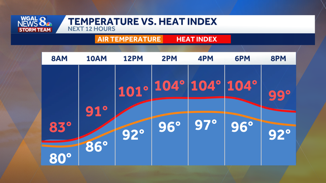
Wednesday is expected to be the hottest day of the week. Afternoon temperatures in the upper 90s, combined with dew points near 70, will make it feel as hot as 100 to 104 degrees.
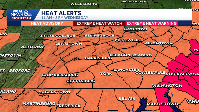
A heat advisory is in effect for the entire Susquehanna Valley from 11 a.m. to 8 p.m.
Near-record heat
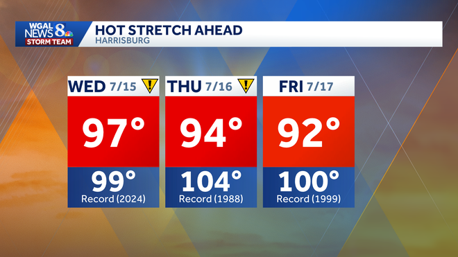
In Harrisburg, the high is expected to reach 97 degrees Wednesday, just shy of the daily record of 99 set in 2024.
Heat eases slightly, but stays uncomfortable
The heat is expected to ease somewhat on Thursday as a weak cold front drops south. Humidity should come down slightly, but it will still feel like the upper 90s, with a high near 92.
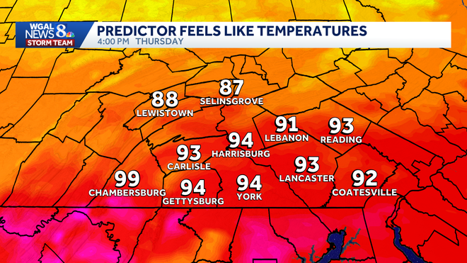
By Friday, humidity is expected to drop further, making conditions less intense even though highs will still reach the lower 90s.
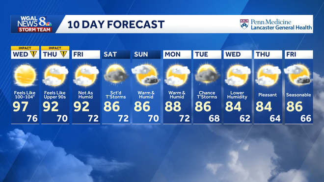
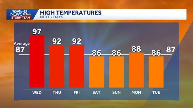
Forecast highs for the week:
Wednesday: 97Thursday: 92Friday: 92Saturday: 86Sunday: 86Monday: 88Tuesday: 86
Canadian wildfire smoke may lower temperatures
Wildfires burning in southern Ontario and northern Minnesota are sending a thick plume of smoke across the Great Lakes and Northeast. The smoke is being carried by upper-level northwesterly winds around a large ridge, or heat dome.
For now, the smoke remains elevated in the atmosphere and is not affecting surface air quality. But if thicker smoke sinks closer to the ground, particulate pollution could increase, and residents may notice a campfire smell.
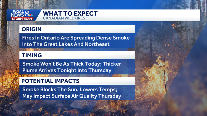
A denser plume is expected to arrive late Wednesday night into Thursday, likely producing:
Hazy or overcast skiesSlightly cooler temperaturesReduced sunshinePossible air quality concerns
Because of the thicker smoke, Thursday’s high has been lowered closer to 90 degrees instead of the mid-90s, as expected earlier this week.
Safety precautions
Residents are urged to take precautions during the heat wave, including:
Stay hydratedTake frequent breaks if outdoorsLimit strenuous afternoon activityCheck on neighbors, children and petsMonitor updated air quality forecasts as smoke moves in
Did you capture a moment that you would like to share with News 8? Send us your photos or videos at https://www.wgal.com/upload.